The Caspian Sea is the largest enclosed body of water on the planet Earth, located on the continent of Eurasia - in the border territory of Russia, Kazakhstan, Turkmenistan, Iran and Azerbaijan. In fact, it is a giant lake remaining after the disappearance of the ancient Tethys Ocean. Nevertheless, there is every reason to consider it as an independent sea (this is indicated by salinity, a large area and decent depth, the bottom from the oceanic crust and other signs). The maximum depth is the third among closed reservoirs - after the lakes Baikal and Tanganyika. In the northern part of the Caspian Sea (a few kilometers from the north coast - parallel to it), the geographical border between Europe and Asia passes.
Toponymy
- Other names: over the entire history of mankind, the Caspian Sea had about 70 different names among different peoples. The most famous of them: Khvalynsk or Khvalis (took place in the time of Ancient Russia, arose on behalf of the people praiseswho lived in the Northern Caspian region and traded with the Russians), Girkanskoye or Dzhurdzhanskoye (derived from alternative names for the city of Gorgan, located in Iran), Khazar, Abeskunsky (by the name of the island and the city in the Kura delta - now flooded), Sarai, Derbent, Sihai .
- Origin of name: according to one hypothesis, the Caspian Sea received its modern and most ancient name from a nomadic horse breeder tribe caspievliving in the 1st millennium BC on the southwest coast.
Morphometry
- Catchment area: 3,626,000 km².
- Mirror Area: 371,000 km².
- Coastline Length: 7 000 km.
- Volume: 78,200 km³.
- Average Depth: 208 m.
- Max Depth: 1,025 m.
Hydrology
- The presence of a constant drain: no, closed.
- Tributaries: , Ural, Emba, Atrek, Gorgan, Heraz, Sephidrud, Astarchay, Kura, Pirsagat, Kusarchay, Samur, Rubas, Darvagchay, Ulluchay, Shuraozen, Sulak, Terek, Kuma.
- Bottom: very diverse. At shallow depths, sandy soil with an admixture of shells is usual, in deep-sea places - silty. Pebble and rocky places can be found in the coastal strip (especially where mountain ranges adjoin the sea). In the estuarine areas, the underwater soil consists of river sediments. The Gulf of Kara-Bogaz-Gol is notable for the fact that its bottom is a powerful layer of mineral salts.
Chemical composition
- Water: brackish.
- Salinity: 13 g / l
- Transparency: 15 m
Geography

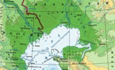
Fig. 1. Map of the Caspian Sea basin.
- Coordinates: 41 ° 59′02 ″ s W, 51 ° 03′52 ″ in d.
- Height above sea level: -28 m.
- Coastal landscape: due to the fact that the coastline of the Caspian Sea is very long, and it is located in different geographical zones - the coastal landscape is diverse. In the northern part of the reservoir, the shores are low, swampy, in the places of the deltas of large rivers indented by numerous channels. The eastern shores are mostly limestone - desert or semi-desert. The western and southern shores are adjacent to the mountain ranges. The greatest indentation of the coastline is observed in the west - in the region of the Absheron peninsula, as well as in the east - in the area of \u200b\u200bthe Kazakh and Kara-Bogaz-Gol bays.
- Settlements on the shores:
- Russia: Astrakhan, Derbent, Kaspiysk, Makhachkala, Olya.
- Kazakhstan: Aktau, Atyrau, Kuryk, Sogandyk, Bautino.
- Turkmenistan: Ekerem, Karabogaz, Turkmenbashi, Khazar.
- Iran: Astara, Balboser, Bender-Torkemen, Bender-Anzely, Neka, Chalus.
- Azerbaijan: Alat, Astara, Baku, Dubendi, Lankaran, Sangachaly, Sumgayit.
Interactive map
Ecology
The ecological situation on the Caspian Sea is far from ideal. Almost all large rivers flowing into it are polluted by the effluents of industrial enterprises located upstream. This could not but affect the presence of pollutants in the waters and bottom sediments of the Caspian - over the past half century, their concentration has increased markedly, and the content of some heavy metals has already exceeded permissible limits.
In addition, the waters of the Caspian Sea are constantly polluted by domestic wastewater from coastal cities, as well as during oil production on the continental shelf, and during its transportation.
Fishing on the Caspian Sea
- Types of fish:
- Artificial settlement: not all of the above fish species in the Caspian Sea are indigenous. About 4 dozen species came by chance (for example, through canals from the basins of the Black and Baltic Seas), or were intentionally inhabited by humans. An example is the mullet. Three Black Sea species of these fish - loban, ostronos and singyl - were released in the first half of the 20th century. Loban did not take root, but the ostronos with a single singlet were successfully acclimatized, and by the current moment they had actually settled throughout the Caspian, having formed several fishing herds. At the same time, fish walk faster than in the Black Sea, and reach larger sizes. In the second half of the last century (starting from 1962), attempts were also made to populate Far Eastern salmon fish such as pink salmon and chum salmon into the Caspian Sea. In total, several billion fry of these fish were released into the sea within 5 years. Pink salmon did not survive in the new range, chum salmon, on the contrary, successfully took root and even began to spawn into rivers flowing into the sea. Nevertheless, she could not reproduce in sufficient quantities and gradually disappeared. There are no favorable conditions for its full natural reproduction (extremely few places where spawning and development of fry could successfully occur). To ensure they need land reclamation, otherwise, without human help (artificial caviar collection and incubation), the fish will not be able to maintain their numbers.


Fishing spots
In fact, fishing is possible anywhere on the coast of the Caspian Sea, which can be reached by land or water. What kind of fish will be caught in this case depends on local conditions, but to a greater extent on whether rivers flow here. As a rule, in places where estuaries and deltas are located (especially large watercourses), water in the sea is highly desalinated, therefore, freshwater fish (carp, catfish, bream, etc.) usually predominate in catches, and species typical for stocks can also be found rivers (barbel, sewn). Of marine species in desalinated areas, those for which salt water does not matter (mullet, some of the gobies) are caught. At certain times of the year, there may be semi-aisle and pass-through species that walk on the sea, and come into rivers for spawning (sturgeon, some of herring, Caspian salmon). In places where there are no flowing rivers, freshwater species are found in a slightly smaller number, but at the same time marine fish appear, usually avoiding desalinated areas (for example, sea pike perch). Far from the coast, fish that prefer salt water and deep-sea species are caught.
Conditionally, you can allocate 9 places or sites interesting in terms of fishing:
- North coast (RF) - this site is located on the northern coast of the Russian Federation (from the Volga delta to the Kizlyar Bay). Its main features are low salinity of water (the lowest in the Caspian Sea), shallow depth, the presence of multiple shallows, islands, and well-developed aquatic vegetation. In addition to the Volga delta with its numerous channels, bays and eriks, this also includes the estuary seaside called the Caspian peals. These places are popular with Russian fishermen, and for good reason: the conditions for fish are very favorable here, there is also a good food supply. The ichthyofauna in these parts may not shine with a wealth of species, but it is different in numbers, and some of its representatives reach very considerable sizes. Typically, the main catch is freshwater fish, characteristic of the Volga basin. Most often caught: perch, pike perch, roach (more precisely - its varieties, called roach and ram), rudd, asp, sabrefish, bream, crucian carp, carp, catfish, pike. Somewhat less often, there are burses, husters, white-eyes, and blue. Representatives of sturgeon (sturgeon, stellate stellate sturgeon, beluga, etc.) and salmonids (nelma, trout - Caspian salmon) are also found in these places, but their catch is prohibited.
- Northwest coast (RF) - this section covers the western coast of the Russian Federation (from Kizlyar Bay to Makhachkala). Here the rivers Kuma, Terek and Sulak flow - they carry their waters both through natural channels and artificial channels. On this site there are bays, among which are quite large (Kizlyarsky, Agrakhansky). The sea in these places is not very deep. Of the fish, fresh-water prevails in the catches: pike, perch, common carp, catfish, rudd, bream, barbel, etc. Marine species are also caught here, for example, herring (black-headed, pod).
- West Bank (RF) - from Makhachkala to the border of the Russian Federation with Azerbaijan. A plot where mountain ranges adjoin the sea. The salinity of the water here is slightly higher than in previous places, therefore, marine species are more common in the catches of fishermen (sea pike perch, mullet, herring). However, freshwater fish are not uncommon.
- West Bank (Azerbaijan) - from the border of the Russian Federation with Azerbaijan on the Absheron Peninsula. Continuation of the plot, where mountain ranges adjoin the sea. Fishing here is even more like a typical sea fishing, thanks to fish such as ostronos and syngil (mullet) and several species of gobies that are also caught here. In addition to them, Kutum, herring, and some typically freshwater species, for example, carp, are found.
- Southwest coast (Azerbaijan) - From the Absheron Peninsula to the border of Azerbaijan with Iran. Most of this section is occupied by the Kura River Delta. Here, the same species of fish are caught that were listed in the previous paragraph, but freshwater is somewhat more common.
- North coast (Kazakhstan) - This section covers the northern coast of Kazakhstan. The Ural Delta and the Akzhayyk State Reserve are located here, therefore fishing is prohibited directly in the river delta and in some adjacent waters. You can fish only outside the reserve - upstream of the delta, or in the sea - at some distance from it. Fishing near the Ural delta has much in common with fishing at the confluence of the Volga - almost the same species of fish are found here.
- Northeast Coast (Kazakhstan) - from the mouth of Emba to Cape Tyub-Karagan. Unlike the northern part of the sea, where the water is greatly diluted by the flowing large rivers, its salinity is slightly increased, therefore, those species of fish appear that avoid desalinated areas, for example, sea pikeperch fishing in the Dead Kultuk Bay. Also, other representatives of marine fauna are often found in catches.
- East coast (Kazakhstan, Turkmenistan) - From Cape Tyub-Karagan to the border of Turkmenistan and Iran. It is distinguished by an almost complete absence of flowing rivers. The salinity of the water here has maximum values. Of the fish in these places, marine species predominate, the basis of catches are mullet, sea pike perch and gobies.
- South coast (Iran) - covers the southern coast of the Caspian. Throughout this section, the Elburs mountain range adjoins the sea. Here many rivers flow, most of which are represented by shallow watercourses, there are also several medium and one large river. Of the fish, in addition to marine species, there are also some freshwater, as well as semi-passage and passage species, for example, sturgeons.
Fishing features
The most popular and catching amateur tackle that is used on the Caspian coast is heavy spinning, converted into a "sea bottom". Usually it is equipped with a strong reel, on which a rather thick fishing line is wound (0.3 mm or more). The thickness of the fishing line is determined not so much by the size of the fish as by the mass of a rather heavy sinker, which is necessary for ultra-long casting (it is generally believed in the Caspian that the farther from the coast the casting point is, the better). After the sinker there is a thinner fishing line - with several leashes. Shrimps and amphipods living in coastal thickets of algae are used as nozzles - if sea fish are supposed to be caught, or an ordinary nozzle like a worm, May beetle larvae and others - if freshwater species are found at the fishing site.
Other gears such as a fishing rod, feeder and traditional spinning can be used at the mouths of flowing rivers.
kasparova2 majorov2006 g2gg2g-61.

Photo 8. Sunset in Aktau.
CASPIAN SEA (Caspian Sea), the largest enclosed body of water on the globe, a drainless brackish lake. Located on the southern border of Asia and Europe, it is washed by the shores of Russia, Kazakhstan, Turkmenistan, Iran and Azerbaijan. Due to the size, the uniqueness of the natural conditions and the complexity of the hydrological processes, the Caspian is usually classified as a closed inland continental sea.
The Caspian Sea is located in a vast area of \u200b\u200binternal flow and occupies a deep tectonic depression. The water level in the sea is at around 27 m below the level of the oceans, an area of \u200b\u200babout 390 thousand km 2, a volume of about 78 thousand km 3. The greatest depth is 1025 m. With a width of 200 to 400 km, the sea is elongated along the meridian for 1030 km.
Largest bays: in the east - Mangyshlak, Kara-Bogaz-Gol, Turkmenbashi (Krasnovodsk), Turkmen; in the west - Kizlyar, Agrakhansky, Kyzylagadzh, Baku bay; in the south - shallow lagoons. There are many islands in the Caspian Sea, but almost all of them are small, with a total area of \u200b\u200bless than 2 thousand km 2. In the northern part there are numerous small islands adjacent to the Volga delta; larger ones - Kulaly, Marine, Tyuleniy, Chechnya. The Absheron archipelago is located on the western shores, the islands of the Baku archipelago lie to the south, and the narrow Ogurchinsky island stretched from north to south.
The northern shores of the Caspian Sea are low-lying and very sloping, characterized by the widespread development of dehydration resulting from overtaking phenomena; delta coasts (the Volga, Urals, Terek deltas) with abundant supply of terrigenous material are also developed here; the Volga delta with extensive reed beds is distinguished. The western shores are abrasive, south of the Absheron peninsula, for the most part, accumulative delta type with numerous mounds and braids. The southern shores are low. The eastern shores are mostly deserted and low-lying, composed of sand.
The relief and geological structure of the bottom.
The Caspian Sea is located in a zone of increased seismic activity. In the city of Krasnovodsk (now Turkmenbashi) in 1895 there was a severe earthquake with a magnitude of 8.2 on the Richter scale. On the islands and coasts of the southern part of the sea eruptions of mud volcanoes are often observed, leading to the formation of new shallows, cans and small islands, eroded by excitement and reappearing.

According to the characteristics of the physical and geographical conditions and the nature of the bottom topography in the Caspian Sea, it is customary to distinguish the North, Middle and South Caspian. The North Caspian is extremely shallow, located completely on the shelf with average depths of 4-5 m.Even small changes in the level here at low coasts lead to significant fluctuations in the area of \u200b\u200bthe water mirror, therefore, the boundaries of the sea in the northeastern part are shown with dashed lines on small-scale maps. The greatest depths (about 20 m) are observed only near the conditional border with the Middle Caspian, which is carried out along the line connecting the island of Chechnya (north of the Agrahan Peninsula) with Cape Tyub-Karagan on the Mangyshlak Peninsula. The Derbent Depression (the greatest depth of 788 m) stands out in the bottom topography of the Middle Caspian. The border between the Middle and South Caspian Sea passes over the Absheron threshold with depths of up to 180 m along the line from Chilov Island (east of the Absheron Peninsula) to Cape Kuuli (Turkmenistan). The basin of the South Caspian is the most extensive area of \u200b\u200bthe sea with the greatest depths, almost 2/3 of the waters of the Caspian Sea are concentrated here, 1/3 fall in the Middle Caspian, and less than 1% of the Caspian waters are in the Northern Caspian due to shallow depths. On the whole, shelf sections prevail in the bottom topography of the Caspian Sea (the entire northern part and a wide strip along the eastern coast of the sea). The mainland slope is most pronounced on the western slope of the Derbent Basin and almost along the entire perimeter of the South Caspian Basin. Terrigenous-shell sands, shell, oolitic sands are common on the shelf; deep-water sections of the bottom are covered with siltstone and silty sediments with a high content of calcium carbonate. In some parts of the bottom, bedrock of Neogene age is exposed. In the Gulf of Ka-ra-Bogaz-Gol, mirabilite is accumulating.
 In the tectonic sense, the southern part of the Caspian Caspian syneclise of the East European Platform is distinguished within the North Caspian, which is framed in the south by the Astrakhan-Aktobe zone, composed of Devonian-Lower Permian carbonate rocks, lying on a volcanic base and containing large deposits of oil and natural combustible gas. The Paleozoic folded formations of the Donetsk-Caspian zone (or Karpinsky ridge), which is the protrusion of the foundations of the young Scythian (in the west) and Turan (in the east) platforms, which are divided at the bottom of the Caspian Sea by the Agrahan-Guryevsky fault (left), are thrust from the southwest to the syneclise shear) northeast strike. The Middle Caspian mainly belongs to the Turan platform, and its southwestern outskirts (including the Derbent Depression) is a continuation of the Tersko-Caspian forward deflection of the folding system of the Greater Caucasus. The sedimentary cover of the platform and the deflection, composed of Jurassic and younger sediments, encloses deposits of oil and combustible gas in local uplifts. The Absheron threshold separating the Middle Caspian from the South is a closing link of the Cenozoic folded systems of the Greater Caucasus and Kopetdag. The South Caspian basin of the Caspian Sea with an oceanic or transitional crust is filled with a powerful (over 25 km) Cenozoic sedimentation complex. Numerous large hydrocarbon deposits are concentrated in the South Caspian basin.
Until the end of the Miocene, the Caspian Sea was the marginal sea of \u200b\u200bthe ancient Tethys Ocean (from the Oligocene - the relict oceanic basin of Paratethis). By the beginning of the Pliocene, it lost contact with the Black Sea. The North and Middle Caspian were drained, and the Paleo-Volga valley stretched through them, the delta of which was located in the region of the Absheron Peninsula. Delta sediments have become the main reservoir of oil and natural combustible gas deposits in Azerbaijan and Turkmenistan. In the Late Pliocene, due to the Akchagyl transgression, the area of \u200b\u200bthe Caspian Sea increased significantly and communication with the World Ocean temporarily resumed. Sea waters covered not only the bottom of the modern depression of the Caspian Sea, but also the adjacent territories. In the Quaternary time of transgression (Absheron, Baku, Khazar, Khvalyn) alternated with regressions. The southern half of the Caspian Sea is located in a zone of increased seismic activity.
Climate. The Caspian Sea, which is very elongated from north to south, is located within several climatic zones. In the northern part, the climate is temperate continental, on the west coast - temperate warm, south-west and south coasts lie within the subtropics, on the east coast the desert climate dominates. In winter, the weather forms over the North and Middle Caspian under the influence of Arctic continental and sea air, and the South Caspian is often influenced by southern cyclones. The weather in the west is unstable rainy, in the east dry. In summer, the western and northwestern regions are influenced by the spurs of the Azores atmospheric maximum, and the southeastern regions are influenced by the Iran-Afghanistan minimum, which together creates a dry, stable warm weather. Winds of the north and northwest (up to 40%) and southeast (about 35%) directions prevail over the sea. The average wind speed is about 6 m / s, in the central regions of the sea up to 7 m / s, in the region of the Absheron peninsula - 8-9 m / s. Northern storm "Baku Nords" reach a speed of 20-25 m / s. The lowest average monthly air temperatures of -10 ° C are observed in January - February in the north-eastern regions (in the most severe winters reach -30 ° C), in the southern regions of 8-12 ° C. In July - August, the average monthly temperatures over the entire water area of \u200b\u200bthe sea are 25-26 ° С, with a maximum up to 44 ° С on the east coast. The distribution of precipitation is very uneven - from 100 mm per year on the eastern shores to 1700 mm in Lankaran. In the open sea, an average of about 200 mm of precipitation falls annually.
Hydrological regime. Changes in the water balance of the closed sea strongly affect the change in water volume and the corresponding level fluctuations. The long-term average components of the Caspian Sea water balance for the 1900-90s (km 3 / cm layer): river runoff 300/77, precipitation 77/20, underground runoff 4/1, evaporation 377/97, \u200b\u200brunoff to Kara-Bogaz- Goal 13/3, which forms a negative water balance of 9 km 3, or 3 cm layer, per year. According to paleogeographic data, over the past 2000 years, the range of fluctuations in the level of the Caspian Sea reached at least 7 m. Since the beginning of the 20th century, there has been a steady downward trend in the level fluctuations, as a result of which the level dropped by 3.2 m over 75 years and reached the mark in 1977 -29 m (the lowest position in the last 500 years). The surface area of \u200b\u200bthe sea decreased by more than 40 thousand km 2, which exceeds the area of \u200b\u200bthe Sea of \u200b\u200bAzov. A rapid increase in level began in 1978, and by 1996 a mark of about -27 m was reached relative to the level of the oceans. In the modern era, fluctuations in the level of the Caspian Sea are determined mainly by fluctuations in climatic characteristics. Seasonal fluctuations in the level of the Caspian Sea are associated with the uneven flow of river runoff (primarily the Volga runoff), therefore, the lowest level is observed in winter, the highest - in summer. Short-term sharp changes in the level are associated with surge phenomena, are most pronounced in shallow northern regions and with storm surges can reach 3-4 m. Such surges cause flooding of significant coastal land areas. In the Middle and Southern Caspian, the wind-driven fluctuations of the level are on average 10-30 cm, under storm conditions - up to 1.5 m. The frequency of surges depending on the region is from one to 5 times a month, the duration is up to one day. In the Caspian Sea, as in any enclosed body of water, seiche level fluctuations are observed in the form of standing waves with periods of 4-9 hours (wind) and 12 hours (tidal). The magnitude of seiche oscillations usually does not exceed 20-30 cm.
River runoff in the Caspian Sea is extremely unevenly distributed. More than 130 rivers flow into the sea, which on average annually bring about 290 km 3 of fresh water. Up to 85% of the river flow falls to the Volga with the Urals and enters the shallow North Caspian. The rivers of the western coast — Kura, Samur, Sulak, Terek, etc. — give up to 10% of the flow. About 5% of fresh water is brought to the South Caspian by the rivers of the Iranian coast. The eastern desert shores are completely devoid of constant fresh runoff.
The average speed of wind currents is 15-20 cm / s, the highest - up to 70 cm / s. In the North Caspian, prevailing winds create a stream directed along the northwest coast to the southwest. In the Middle Caspian, this current merges with the western branch of the local cyclonic circulation and continues to move along the western coast. At the Absheron Peninsula, the current bifurcates. Part of it in the open sea flows into the cyclonic circulation of the Middle Caspian, and the coastal one goes around the coast of the South Caspian and turns north, being included in the coastal current, enveloping the entire east coast. The average state of movement of surface Caspian waters is often disturbed due to variability of wind conditions and other factors. So, in the northeastern shallow area, a local anticyclonic cycle may occur. Two anticyclonic eddies are often observed in the South Caspian. In the Middle Caspian during the warm season, sustained north-westerly winds create a southern transport along the east coast. In light winds and during calm weather, currents can have other directions.
 Wind waves develop very strongly, since the prevailing winds have a long acceleration length. Excitement develops predominantly in the northwest and southeast directions. Strong storms are observed in the open water area of \u200b\u200bthe Middle Caspian, in the areas of the city of Makhachkala, the Absheron Peninsula and the Mangyshlak Peninsula. The average wave height of the greatest repeatability is 1-1.5 m, with wind speeds of more than 15 m / s it increases to 2-3 m. The highest wave heights were noted during severe storms in the area of \u200b\u200bthe Oil Stones hydrometeorological station: 7-8 m annually, in some cases up to 10 m
The water temperature on the sea surface in January - February in the Northern Caspian is close to the freezing temperature (about -0.2 - -0.3 ° C) and gradually rises southward to 11 ° C off the coast of Iran. In summer, surface water warms up to 23-28 ° С everywhere, except for the eastern shelf of the Middle Caspian, where seasonal coastal upwelling develops in July - August and the water temperature on the surface drops to 12-17 ° С. In winter, due to intense convective mixing, the water temperature changes little with depth. In summer, under the upper heated layer, at the horizons of 20-30 m, a seasonal thermocline is formed (a layer of a sharp change in temperature), which separates deep cold waters from warm surface ones. In the bottom layers of the deep-sea basins, the temperature remains at 4.5-5.5 ° С in the Middle Caspian and 5.8-6.5 ° С in the South all year round. Salinity in the Caspian Sea is almost 3 times lower than in open areas of the World Ocean, and averages 12.8-12.9 ‰. It should be especially emphasized that the salt composition of Caspian water is not completely identical to the composition of ocean waters, which is explained by the isolation of the sea from the ocean. The waters of the Caspian Sea are poorer in sodium salts and chlorides, but richer in calcium and magnesium carbonates and sulfates because of the unique composition of salts entering the sea with river and underground runoff. The highest salinity variability is observed in the Northern Caspian, where in the estuarine parts of the Volga and the Urals the water is fresh (less than 1 ‰), and as you move south, the salt content increases to 10-11 ‰ on the border with the Middle Caspian. The largest horizontal salinity gradients are characteristic of the frontal zone between sea and river waters. Differences in salinity between the Middle and South Caspian are small, salinity increases slightly from northwest to southeast, reaching 13.6 ‰ in the Turkmen Bay (up to 300 ‰ in Kara-Bogaz-Gol). Vertical salinity changes are small and rarely exceed 0.3 ‰, which indicates good vertical mixing of the waters. Water transparency varies widely from 0.2 m in the estuarine areas of large rivers to 15-17 m in the central regions of the sea.
According to the ice regime, the Caspian Sea belongs to partially freezing seas. Ice conditions are observed annually only in the northern regions. The North Caspian is completely covered by sea ice, the Middle - partially (only in severe winters). The middle boundary of sea ice extends along an arc convex to the north, from the Agrahan peninsula in the west to the Tyub-Karagan peninsula in the east. Usually, ice formation begins in mid-November in the extreme northeast and gradually spreads to the southwest. In January, the entire Northern Caspian is covered with ice, mostly ice fast ice (motionless). Drifting ice borders the fast ice with a strip of 20-30 km wide. The average ice thickness is from 30 cm at the southern border to 60 cm in the northeastern regions of the North Caspian, in hummocky piles - up to 1.5 m. The destruction of the ice cover begins in the 2nd half of February. In severe winters, drifting ice drifts to the south are observed along the western coast, sometimes up to the Absheron peninsula. In early April, the sea is completely cleared of ice.
Research history . It is believed that the modern name of the Caspian Sea comes from the ancient Caspian tribes that inhabited coastal areas in the 1st millennium BC; other historical names: Hyrcanic (Irkansky), Persian, Khazar, Khvalynsk (Khvalis), Khorezm, Derbent. The first mention of the existence of the Caspian Sea dates back to the 5th century BC. Herodotus was one of the first to argue that this reservoir is isolated, that is, it is a lake. In the works of Arab scholars of the Middle Ages, there is evidence that in the 13-16 centuries the Amu Darya partially fell into this sea with one of the branches. The well-known numerous ancient Greek, Arab, European, including Russian, maps of the Caspian Sea until the beginning of the 18th century did not reflect reality and were actually arbitrary drawings. By order of Tsar Peter I in 1714-15 an expedition was organized under the leadership of A. Bekovich-Cherkassky, who explored the Caspian Sea, in particular its eastern shores. The first map, on which the coastal contours are close to modern, was compiled in 1720 using astronomical definitions by Russian military hydrographs F.I.Soymonov and K. Verdun. In 1731, Soimonov published the first atlas, and soon the first printed patrol of the Caspian Sea. A new edition of the maps of the Caspian Sea with corrections and additions was carried out by Admiral A.I. Nagaev in 1760. The first information on the geology and biology of the Caspian Sea was published by S. G. Gmelin and P. S. Pallas. Hydrographic studies in the 2nd half of the 18th century were continued by I.V. Tokmachev, M.I. Voinovich, and in the beginning of the 19th century by A.E. Kolodkin, who first performed instrumental compass surveys of the coasts. In 1807 a new map of the Caspian Sea was published, compiled taking into account the latest inventories. In 1837, systematic instrumental observations of sea level fluctuations began in Baku. In 1847, the first complete description of the Kara-Bogaz-Gol Bay was completed. In 1878, the General Map of the Caspian Sea was published, which reflected the results of recent astronomical observations, hydrographic surveys and measurements of depths. In 1866, 1904, 1912-13, 1914-15, expeditionary research was conducted under the supervision of N. M. Knipovich on the hydrology and hydrobiology of the Caspian; in 1934, the Commission for the Comprehensive Study of the Caspian Sea was established at the USSR Academy of Sciences. Soviet geologists I. made a great contribution to the study of the geological structure and oil potential of the Absheron Peninsula and the geological history of the Caspian Sea. M. Gubkin, D.V. and V. D. Golubyatnikovs, P. A. Pravoslavlev, V. P. Baturin, S. A. Kovalevsky; in the study of water balance and sea level fluctuations - B. A. Appolov, V. V. Valedinsky, K. P. Voskresensky, L. S. Berg. After the Great Patriotic War, systematic comprehensive studies were launched on the Caspian Sea, aimed at studying the hydrometeorological regime, biological conditions and geological structure of the sea.
In the 21st century, two major research centers are engaged in solving the problems of the Caspian Sea in Russia. The Caspian Marine Research Center (CaspMNITs), established in 1995 by a decree of the Government of the Russian Federation, conducts research work on hydrometeorology, oceanography and ecology. The Caspian Fisheries Research Institute (CaspNIRKh) traces its history back to the Astrakhan Research Station [established in 1897, from 1930 the Volga-Caspian Fisheries Research Station, from 1948 the Caspian Branch of the All-Russian Fisheries and Oceanography Research Institute, from 1954 Caspian Research Institute of Marine Fisheries and Oceanography (CaspNIRO), modern name since 1965]. CaspNIRKh is developing the basics of conservation and rational use of biological resources of the Caspian Sea. It consists of 18 laboratories and scientific departments - in Astrakhan, Volgograd and Makhachkala. It has a scientific fleet of more than 20 vessels.
Economic use. The natural resources of the Caspian Sea are rich and diverse. Significant hydrocarbon reserves are actively developed by Russian, Kazakh, Azerbaijani and Turkmen oil and gas companies. Huge reserves of mineral self-settling salts in the Gulf of Kara-Bogaz-Gol. The Caspian region is also known as a massive habitat for waterfowl and near-water birds. Across the Caspian Sea, about 6 million migratory birds migrate annually. In this regard, the Volga delta, Kyzylagadj bays, Northern Cheleken and Turkmenbashi are recognized as lands of international rank under the Ramsar Convention. The estuaries of many rivers flowing into the sea have unique types of vegetation. The fauna of the Caspian Sea is represented by 1800 species of animals, of which 415 are vertebrate species. More than 100 species of fish inhabit the sea and estuarine sections of rivers. Marine species - herring, sprats, sprats, gobies, sturgeons are of commercial importance; freshwater - cyprinids, perches; Arctic “invaders” - salmon, whitefish. Major ports: Astrakhan, Makhachkala in Russia; Aktau, Atyrau in Kazakhstan; Turkmenbashi in Turkmenistan; Bender-Torkemen, Bender-Anzeli in Iran; Baku in Azerbaijan.
Ecological state. The Caspian Sea is under a powerful anthropogenic impact due to the intensive development of hydrocarbon deposits and the active development of fishing. In the 1980s, the Caspian Sea accounted for up to 80% of the global sturgeon catch. The predatory catches of recent decades, poaching and a sharp deterioration in the ecological situation have put many valuable fish species on the brink of extinction. The living conditions of not only fish, but also birds and marine animals (Caspian seal) have worsened. The countries washed by the waters of the Caspian Sea are faced with the problems of creating a set of international measures to prevent pollution of the aquatic environment and developing the most effective environmental strategy for the near future. A stable ecological state is observed only in parts of the sea remote from the coast.
Lit .: Caspian Sea. M., 1969; Comprehensive studies of the Caspian Sea. M., 1970. Issue. 1; Gul K.K., Lappalainen T.N., Polushkin V.A. Caspian Sea. M., 1970; Zalogin B.S., Kosarev A.N. Sea. M., 1999; International tectonic map of the Caspian Sea and its frame / Ed. V.E. Khain, N.A. Bogdanov. M., 2003; Zonn I.S. Caspian Encyclopedia. M., 2004.
M. G. Deev; V.E. Khain (geological structure of the bottom).
The Caspian is simultaneously considered as a closed lake and a full sea. The causes of this confusion are brackish waters and a hydrological regime similar to that of the sea.
The Caspian Sea is located on the border of Asia and Europe. Its area is about 370 thousand km 2, the maximum depth is just over one kilometer. The Caspian has a conditional division into three almost equal parts: the South (39% of the area), the Middle (36%) and the North (25%).
The sea is washed simultaneously by Russian, Kazakh, Azerbaijani, Turkmen and Iranian shores.
Coast of the Caspian Sea (Caspian littoral) has a length of about 7 thousand kilometers, if you count along with the islands. In the north, the low sea coast is covered with swamps and thickets, has multiple water channels. The eastern and western coasts of the Caspian Sea have a meandering shape, in some places the coasts are covered with limestone.
There are many islands in the Caspian: Dash-Zira, Kury Dashi, Dzhambaysky, Boyuk-Zira, Gum, Chigil, Here-Zira, Zenbil, Ogurchinsky, Tyuleny, Ashur-Ada, etc. Peninsulas: Mangyshlak, Tyub-Karagan, Absheron and Miankale. Their total area is approximately 400 km 2.
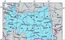
It flows into the Caspian Sea more than a hundred different rivers, the most significant - the Urals, Terek, Volga, Atrek, Emba, Samur. Almost all of them provide the sea with 85–95% of the annual drain.
The largest bays of the Caspian: Kaydak, Agrakhansky, Kazakh, Dead Kultuk, Turkmenbashi, Mangyshlaksky, Gizlar, Girkan, Kaydak.

Climate of the Caspian
The Caspian Sea is located immediately in three climatic zones: subtropical climate in the south, continental in the north and temperate in the middle. In winter, the average temperature varies from ‒10 to +10 degrees, in summer, the air warms up to about +25 degrees. From 110 mm of precipitation in the east and up to 1500 mm in the west fall annually.
The average wind speed is 3–7 m / s, but in autumn and winter it often increases to 35 m / s. The most purged territories are the coastal areas of Makhachkala, Derbent and the Absheron Peninsula.
Water temperature in the Caspian Sea ranges from zero to +10 degrees in the winter, and from 23 to 28 degrees in the summer months. In some coastal shallow waters, water can warm up to 35–40 degrees.
Only the northern part of the sea is subject to freezing, but in especially cold winters the coastal zones of the middle part are added to it. The ice cover appears in November and disappears only in March.

Problems of the Caspian region
Water pollution is one of the main environmental problems of the Caspian. Oil production, various harmful substances from flowing rivers, waste products from nearby cities - all this negatively affects the state of sea water. Additional troubles are also created by poachers, whose actions reduce the number of fish of certain species leading to the Caspian Sea.
Sea level rise also causes serious financial damage to all the Caspian countries.
According to conservative estimates, the restoration of destroyed buildings and the implementation of comprehensive measures to protect the coast from flooding costs tens of millions of dollars.

Cities and resorts on the Caspian Sea
The largest city and port washed by the waters of the Caspian is Baku. Among other settlements of Azerbaijan, located in close proximity to the sea, are Sumgait and Lankaran. The city of Turkmenbashi is located on the eastern shores, and about ten kilometers from it by the sea is the large Turkmen resort of Avaza.
The following cities are located on the seashore from the Russian side: Makhachkala, Izberbash, Derbent, Lagan and Kaspiysk. Astrakhan is often called the port city, although it is located about 65 kilometers from the northern shores of the Caspian.

Astrakhan
Beach holidays in this region are not provided: along the sea coast there are only continuous reed thickets. However, tourists go to Astrakhan not for idle lying on the beach, but for fishing and various types of outdoor activities: diving, catamarans, jet skis, etc. In July and August, excursion motor ships ply the Caspian.

Dagestan
For a classic seaside vacation, it is better to go to Makhachkala, Kaspiysk or Izberbash - this is where not only good sandy beaches are located, but also worthy recreation centers. The range of entertainment on the seashore from the Dagestan side is quite wide: swimming, therapeutic mud springs, windsurfing, kiting, rock climbing and paragliding.
The only minus of this direction is the underdeveloped infrastructure.
In addition, there is an opinion among some Russian tourists that Dagestan is far from being the most peaceful territory that is part of the North Caucasus Federal District.

Kazakhstan
A much more relaxed atmosphere can be found in the Kazakh resorts of Kuryk, Atyrau and Aktau. The latter is the most popular tourist city in Kazakhstan: there are many good places of entertainment and well-maintained beaches. In summer, the temperature is very high, reaching +40 degrees during the day, and dropping only to +30 at night.
The disadvantages of Kazakhstan as a tourist country are the same poor infrastructure and rudimentary transport links between the regions.

Azerbaijan
The best places to relax on the Caspian coast are considered to be Baku, Nabran, Lankaran and other Azerbaijani resorts. Fortunately, with the infrastructure in this country, everything is fine: for example, in the area of \u200b\u200bthe Absheron Peninsula several modern comfortable hotels with pools and beaches have been built.
However, in order to relax with pleasure on the Caspian Sea in Azerbaijan, it is necessary to spend a lot of money. In addition, you can get to the same Baku quickly enough only by plane - trains rarely run, and the journey from Russia takes two to three days.
Tourists should not forget that Dagestan and Azerbaijan are Islamic countries, therefore, all the "unfaithful" need to adjust their usual behavior to local customs.
Subject to simple rules of stay, nothing will spoil your vacation on the Caspian Sea.
, Kazakhstan, TurkmenistanIran Azerbaijan
Geographical position

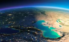
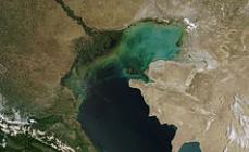
Caspian Sea - view from space.
The Caspian Sea is located at the junction of two parts of the Eurasian continent - Europe and Asia. The length of the Caspian Sea from north to south is approximately 1,200 kilometers (36 ° 34 "-47 ° 13" N), from west to east - from 195 to 435 kilometers, an average of 310-320 kilometers (46 ° -56 ° E).
The Caspian Sea is conditionally divided into 3 parts according to physical and geographical conditions - the North Caspian, the Middle Caspian and the South Caspian. The conditional border between the North and the Middle Caspian passes along the line about. Chechnya - Cape Tyub-Karagansky, between the Middle and South Caspian - along the line of about. Residential - Cape Gan-Gulu. The area of \u200b\u200bthe Northern, Middle and Southern Caspian is 25, 36, 39 percent, respectively.
Coast of the Caspian Sea

Caspian Sea coast in Turkmenistan
The territory adjacent to the Caspian Sea is called the Caspian Sea.
Peninsulas of the Caspian Sea
- Ashur Ada
- Garasu
- Zyanbil
- Hara Zira
- Sengi Mugan
- Chygyl
Bays of the Caspian Sea
- Russia (Dagestan, Kalmykia and Astrakhan region) - in the west and northwest, the coastline is about 1930 kilometers
- Kazakhstan - in the north, northeast and east, the coastline is about 2320 kilometers long
- Turkmenistan - in the southeast, the coastline is about 650 kilometers
- Iran - in the south, the coastline is about 1000 kilometers
- Azerbaijan - in the south-west, the coastline is about 800 kilometers
Cities on the coast of the Caspian Sea
The cities located on the Russian coast are Lagan, Makhachkala, Kaspiysk, Izberbash and the southernmost city of Russia, Derbent. The port city of the Caspian Sea is also considered Astrakhan, which, however, is not located on the Caspian Sea, but in the Volga Delta, 60 kilometers from the northern coast of the Caspian Sea.
Physiography
Area, depth, volume of water
The area and volume of water in the Caspian Sea varies significantly depending on fluctuations in water level. At a water level of −26.75 m, the area is approximately 371,000 square kilometers, the volume of water is 78,648 cubic kilometers, which is approximately 44% of the world's lake water reserves. The maximum depth of the Caspian Sea is in the South Caspian Depression, 1025 meters from its surface level. In terms of maximum depth, the Caspian Sea is second only to Baikal (1620 m) and Tanganyika (1435 m). The average depth of the Caspian Sea, calculated from the bathygraphic curve, is 208 meters. At the same time, the northern part of the Caspian is shallow, its maximum depth does not exceed 25 meters, and the average depth is 4 meters.
Water level fluctuations
Vegetable world
The flora of the Caspian Sea and its coast is represented by 728 species. Of the plants in the Caspian Sea, algae prevail - blue-green, diatoms, red, brown, char and others, from flowering plants - zoster and rupiah. By origin, the flora refers mainly to the Neogene age, however, some plants were brought into the Caspian Sea by a person knowingly or on the bottoms of ships.
History of the Caspian Sea
Origin of the Caspian Sea
Anthropological and cultural history of the Caspian Sea
Findings in the Khuto cave off the southern coast of the Caspian Sea indicate that people lived in these parts about 75 thousand years ago. The first mention of the Caspian Sea and the tribes living on its coast are found near Herodotus. Around the V-II centuries. BC e. on the coast of the Caspian lived tribes of Saks. Later, during the period of resettlement of the Turks, during the period of the 4th-5th centuries. n e. Talysh tribes (Talysh) lived here. According to ancient Armenian and Iranian manuscripts, Russians sailed the Caspian Sea from the 9th-10th centuries.
Exploration of the Caspian Sea
Explorations of the Caspian Sea began by Peter the Great, when, on his orders in 1714-1715, an expedition was organized under the leadership of A. Bekovich-Cherkassky. In the 1720s, hydrographic studies were continued by the expedition of Karl von Verdun and F.I. Soymonov, later by I.V. Tokmachev, M.I. Voinovich and other researchers. At the beginning of the XIX century, instrumental survey of the coast was carried out by I.F. Kolodkin, in the middle of the 19th century. - instrumental geographical survey under the direction of N. A. Ivashintsev. Since 1866, expeditionary research on the hydrology and hydrobiology of the Caspian under the direction of N. M. Knipovich has been conducted for over 50 years. In 1897, the Astrakhan Research Station was founded. In the first decades of Soviet power in the Caspian Sea, geological explorations of I.M. Gubkin and other Soviet geologists were actively conducted, mainly aimed at finding oil, as well as studies on the water balance and fluctuations in the level of the Caspian Sea.
The economy of the Caspian Sea
Mining of oil and gas
In the Caspian Sea, many oil and gas fields are being developed. Proven oil resources in the Caspian Sea are about 10 billion tons, total oil and gas condensate resources are estimated at 18-20 billion tons.
Oil production in the Caspian Sea began in 1820, when the first oil well was drilled on the Absheron shelf near Baku. In the second half of the 19th century, oil production commercially began on the Absheron Peninsula, and then - in other territories.
Shipping
The Caspian Sea has developed shipping. There are ferry crossings on the Caspian Sea, in particular, Baku - Turkmenbashi, Baku - Aktau, Makhachkala - Aktau. The Caspian Sea has shipping links with the Sea of \u200b\u200bAzov through the Volga, Don and Volga-Don Canal rivers.
Seafood fishing and fishing
Fishing (sturgeon, bream, common carp, pike perch, sprats), caviar extraction, as well as seal fishing. In the Caspian Sea, more than 90 percent of the world's sturgeon catch is carried out. In addition to commercial production, illegal production of sturgeon and their caviar thrives in the Caspian Sea.
Recreational resources
The natural environment of the Caspian coast with sandy beaches, mineral waters and healing mud in the coastal zone creates good conditions for relaxation and treatment. At the same time, according to the degree of development of resorts and tourism industry, the Caspian coast noticeably loses to the Black Sea coast of the Caucasus. However, in recent years, the tourism industry has been actively developing on the coast of Azerbaijan, Iran, Turkmenistan and Russian Dagestan. A resort area in the Baku region is actively developing in Azerbaijan. At the moment, a world-class resort has been created in Amburan, another modern tourist complex is being built in the area of \u200b\u200bthe village of Nardaran, holidays in the sanatoriums of the villages of Bilgyakh and Zagulba are very popular. A resort area is also developing in Nabran, in the north of Azerbaijan. However, high prices, generally low level of service and lack of advertising lead to the fact that there are almost no foreign tourists in the Caspian resorts. The development of the tourism industry in Turkmenistan is hindered by a long policy of isolation, in Iran - by Sharia law, because of which mass recreation of foreign tourists on the Caspian coast of Iran is impossible.
Environmental problems
The environmental problems of the Caspian Sea are associated with water pollution resulting from oil production and transportation on the continental shelf, the influx of pollutants from the Volga and other rivers flowing into the Caspian Sea, the vital activity of coastal cities, as well as the flooding of individual facilities due to an increase in the level of the Caspian Sea. Predatory production of sturgeon and their eggs, rampant poaching lead to a decrease in the number of sturgeon and to forced restrictions on their production and export.
The international status of the Caspian Sea
Legal status of the Caspian Sea
After the collapse of the USSR, the division of the Caspian Sea has long been and still remains the subject of unresolved disagreements related to the division of the Caspian shelf resources - oil and gas, as well as biological resources. For a long time, negotiations were ongoing between the Caspian states on the status of the Caspian Sea - Azerbaijan, Kazakhstan and Turkmenistan insisted on dividing the Caspian along the midline, Iran - on dividing the Caspian in one fifth of all the Caspian states.
With regard to the Caspian, the key physical and geographical circumstance is that it is a closed inland water body that does not have a natural connection to the World Ocean. Accordingly, the norms and concepts of international maritime law, in particular, the provisions of the UN Convention on the Law of the Sea of \u200b\u200b1982, should not automatically apply to the Caspian Sea. Based on this, it would be unlawful to apply such concepts as the "territorial sea", "exceptional economic zone ”,“ continental shelf ”, etc.
The current legal regime of the Caspian is established by the Soviet-Iranian treaties of 1921 and 1940. These agreements provide for freedom of navigation throughout the sea, freedom of fishing with the exception of the ten-mile national fishing zones and a ban on the sailing of vessels flying the flag of non-Caspian states in its water area.
Negotiations on the legal status of the Caspian are ongoing.
Delimitation of sections of the Caspian bottom for subsoil use
The Russian Federation concluded an agreement with Kazakhstan on delimiting the bottom of the northern part of the Caspian Sea in order to exercise sovereign rights for subsoil use (dated July 6, 1998 and its Protocol of May 13, 2002), an agreement with Azerbaijan on the delimitation of adjacent sections of the bottom of the northern part of the Caspian Sea (dated September 23, 2002), as well as the trilateral Russian-Azerbaijani-Kazakh agreement on the junction of the demarcation lines of adjacent sections of the bottom of the Caspian Sea (dated May 14, 2003), which established the geographical coordinates of the dividing lines bordering the bottom sections, within which the sides exercise their sovereign rights in the field of exploration and production of mineral resources.
One of the brightest reservoirs in the world is the Caspian Lake, which is located at the junction of Asia and Europe, and its shores and water belong to 5 countries. The Caspian is an attractive and inexpensive place for recreation and treatment. Beautiful nature and the early opening of the bathing seasons make the holiday on the Caspian coast more attractive.
The Caspian Lake is the largest of all lakes on the planet. It is often called the Caspian Sea because of its impressive size and slightly salty water. It is located at the junction of Asia and Europe in the territory of 5 countries: Turkmenistan, Kazakhstan, the Russian Federation of Azerbaijan and Iran.
Despite the fact that tourism infrastructure is inferior in development to the Black Sea, the Caspian coast is in demand among tourists. This is facilitated by the rapid warming of the reservoir due to its small depth, often the swimming season can begin at the end of April, and end in October. The average water temperature in summer is 20-22 ° C.
Benefits of relaxing on the Caspian Lake:
- clean sea sand;
- picturesque nature;
- marine healing climate;
- mineral springs;
- healing mud;
- the presence of sanatoriums of various orientations;
- excellent fishing, especially in Astrakhan;
- active entertainment for every taste (diving, rafting, windsurfing, etc.);
- low cost of housing and entertainment with developed infrastructure;
- stay on the territory of the Russian Federation, which saves a lot of time on paperwork;
- great service;
- warm water for six months;
- the opportunity to save more than one thousand rubles on vacation, housing and food without denying anything to yourself.
You can get to the Caspian Sea in various ways, but it’s worth deciding in which coastal city you should plan a vacation.
There are several resort towns in the Russian Federation on the Caspian Lake:
Astrakhan is very popular among fishermen and lovers of outdoor activities related to water, because in its vicinity there are many rivers, and even the Caspian Lake is within easy reach - an hour by car.
The ancient city of Derbent also enjoys special love among tourists, because it is surrounded by attractions such as picturesque mountains, there are ancient fossils and legendary caves, overgrown with legends, and other places of interest to visitors.
Such Dagestan resort cities as Izberbash, Kaspiysk, Makhachkala and Kalmyk Lagan are not deprived of attention either. A lot of tourists come to the Caspian Lake and stay in Azerbaijani cities (Baku, Lankaran, Sumgait), the Turkmen resort of Turkmentbashi and Avaza, Kazakhstan Aktau and Atyrau.
Origin of the Caspian Lake and its name
Over 5 million years ago, the ancient sea was divided into several smaller ones, including the Caspian and the Black Sea. Upon the occurrence of this separation, the reservoirs repeatedly merged into one and crushed, but about 1.75-2 million years ago, the reservoir was finally cut off from the waters of the oceans.
The modern name of the Caspian Lake is new. And according to one hypothesis, it came from the name of the Kaspiiv tribe, who lived in its southwest in the first millennium BC. 
Throughout the entire period of its existence, the Caspian Lake has more than 70 different names among the different peoples of the tribes, among which:
- Abeskunskoye - according to the name of the island and the city, which were located before the flood in the 14th century in a lowland plain formed by the Kura Kura River.
- Sarai.
- The Khazar or Mazenderan - the Iranian name in honor of the province of the same name located on the coast, is used in Iran to this day.
- Dzhurdzhan (Girkanskoe) - the ancient Greek name of the reservoir, came from the region of Girkania and the city of Gorgan, now related to Iran.
- Derbent - by the name of the ancient coastal town of the same name in Dagestan.
- Sikhayskoe.
- Hwali is an Old Russian name, derived from the name of the people of Hvalis living in the north of the Caspian.
Study and development of the Caspian Lake
Findings on the western coast of Dagestan indicate that people lived in this territory already 2 million ago. At the confluence of the river. Darvagchay (Dagestan) excavated the remains of parking lots older than 600 thousand years. Excavations on the south coast indicate a person lived in this area 75 thousand years ago. All these studies show that the climate and living conditions were suitable for humans.
The founder of geography and writer Hekatey Miletus (VI-V century BC) in his work "Geography" described the Caspian Sea as the Hyrcanic Sea. In the 5th century BC, the ancient Greek historian was one of the first to suggest that the Caspian Sea does not bind to other seas or the ocean, although scientists of those times claimed that the reservoir was the northern gulf of the World Ocean, which washed all the known lands.
Aristotle in the 4th century BC was convinced that the Girkan pond was connected with the Black Sea by underground waters. A study of the relationship of the Caspian Sea with other large bodies of water was carried out by Macedonian during his travels. In 323 BC, he sent a sailor and geographer Patroclus to explore the shores of the Caspian. 
The sailor reached the Kara-Bogaz Bay and considered it a river that connects the Caspian Lake with the ocean. The famous ancient Greek geographer and historian Strabon in one of his 17 annals (books) of “Geography” presented the Caspian Lake stretched in the east-west direction.
Arab scholars of the 9th-13th centuries made their significant contribution to the exploration of the Caspian, recording in their works information on coastal cities and states, islands, flowing rivers and oil that was extracted in Azerbaijan (Baku).
The expansion of the geography of trade relations has provided a wealth of information about the Caspian to European, Persian and Turkish travelers. And the eminent Marco Polo (XIII century) also described a huge reservoir.
A very detailed, although sometimes erroneous, map of the Caspian was compiled in the 17th century by the famous scientist and traveler, the German Adam Olearius. Peter I repeatedly traveled in the direction of the Caspian Lake, and on the basis of the data provided by him, the Russian hydrographs made very detailed maps of the Caspian.
Since the 17th century, surveys of the Caspian and its coastal environs have become systematic and versatile. Peter the Great in 1714 sent a research expedition led by Bekovich-Cherkassky. A few years later, research continued by Verdun and Soimonov, a little later Tokmachev, Voinovich and other scientists.
At the beginning of the XIX century, instrumental survey of the coast was carried out by Kolodkin I.F., several decades later, a geographic survey was carried out by an expedition led by N. Ivashintsev. For half a century, starting in 1866, regular expeditions of hydrological and hydrobiological orientation were conducted under the leadership of N. Knipovich.
The first years of Soviet rule, the Caspian Sea was actively examined by geologists, mainly in search of oil products, studying the water balance and fluctuations in the height of the water in the lake.
History of the Caspian Lake
The Caspian Lake is located on the site of one of the giant reservoirs of antiquity. The origin of the Caspian Lake is inextricably linked with the ancient Tetris Sea, which more than 50-55 million years ago united the Pacific and Atlantic Oceans, located on the territory of the present Caspian, Azov, Black and Mediterranean Seas. 
After a long complex tectonic movement, Tetris was first cut off from the Pacific Ocean, and a little later, the Atlantic.
About 5-6.5 million years ago, a giant reservoir broke into shallow basins, which included the Caspian and the Black Sea.
After that, they repeatedly united and moved apart.
1.8-2 million years ago, the Caspian was finally cut off from the waters of the oceans and it is this time that is considered the beginning of its inception.
Throughout its history, the lake has repeatedly changed its coastline until it has acquired its current form.
Physico-geographical characteristics of the Caspian Lake
The water surface of the lake is noticeably lower than the level of the World Ocean and is -27.5 ... -28.5 m. The Caspian Sea area varies depending on the level and water and is in the range of 380-390 km2, the total volume is 73.7-74.1 km3 .
The Caspian is territorially divided into several parts with its own characteristics:
- North Caspian - 24% of the total area of \u200b\u200bthe reservoir falls on it. This part is shallow, and its average depth does not exceed 6 m, the maximum reaches 25 m, the volume of water is less than 1%.
- Middle Caspian - 36% of the total lake area falls on it. This part of the lake is a kind of hollow with a maximum depth of almost 800 m, and averaged - 190 m. It contains a third of the total volume of water.
- South Caspian - occupies 40% of the total area of \u200b\u200bthe lake and it accounts for the deepest part of the reservoir. It contains 2/3 of the volume of all water - 66%. The average depth is 340 m and the deepest trench is 1025 m.
The length of the coastline almost reaches 7 thousand km. The maximum length of the lake slightly exceeds 1 thousand km, and the widest place is 435 km. The minimum width is considered to be a segment of 195 km. The average width is considered to be 317 km.
 Depth Map of Caspian Lake
 The shores vary greatly in their landscape. The northern coast is shallow and low, around it there is a semi-desert in the lowland, and on the hill - the desert. The southern coast is partly low and partly mountainous and consists of the Elbrus ridge. The mountains of the Caucasus come close to the western part.
The eastern coastline is a desert and semi-desert calcareous plateau. The shape of the coast varies greatly depending on the water level, which periodically fluctuates.
Climate
The temperature of the Caspian Sea varies greatly depending on latitude. Such an amplitude is most noticeable in winter, when the water under ice in the northern part has a temperature of 0, -0.5 ° С above zero, in the south at that time it is 10-11 ° С.
According to averaged data, the temperature in the western part of the lake is up to 2 ° C higher than in the eastern one, and when it is removed from the coast, it rises by 2-4 ° C compared with the coastal zone. In summer, the water in the lake warms up to 23-29 ° C, and in shallow water in the northern part it can reach 34-40 ° C. Below 100 m, the temperature stabilizes and is 4-7 ° C.
The Caspian Lake is located in three climatic zones: continental (north of the reservoir), moderate (middle) and subtropical (South Caspian). In winter, the average temperature ranges from -8 to -11 ° C in the north and to +8 to +11 ° C in the south of the lake.
In summer, the northern part warms up to 24-25 ° C with a positive mark, in the south the temperature rises to 26-27 ° C. The highest temperature +44 ° С was noted in the east of the reservoir. 
The average amount of rainfall per year is about 200 mm. Moreover, at least 90-100 mm falls on the arid eastern coast, in the south-west these indicators can reach 1700 mm. The average annual wind speed is in the range of 3-8 m / s, mainly winds from the north prevail. In autumn and winter, their speed increases and can reach 35-39 m / s.
When the thermometer shows large negative values \u200b\u200bon the northern part of the lake, trees and flowers bloom on the southern coast. In winter, the surface of the lake is unstable, stormy winds prevail. In winter, only the northern shallow water freezes; in severe winter frosts, the North Caspian and the coastal waters of the Middle Caspian are covered with ice.
Flora and fauna
The flora of the Caspian and its coastal environs is more than 720 species of plants. In the lake, algae (diatoms, brown, etc.) predominate, from angiosperms - rupee and zoster. Most of the vegetation of the Caspian Lake comes from the Neogene period, but some fell into the pond on the bottoms of ships or consciously, with the help of humans.
Among animals from the Caspian and its environs, there are more than 1800 species, of which more than 400 are vertebrates, and more than 90 species are fish (sturgeon, carp, bream, mullet, beluga, etc.). Mammals are represented only by the Caspian seal, which is the smallest of the seal family and lives exclusively in the Caspian lake.
The largest flock of sturgeons in the world lives in the lake, also a lot of zander, common carp and roach live in the waters of the sea. Caspian Lake accounts for up to 80% of the total world catch of sturgeon and more than 90% of the world black caviar catch.
The main path of bird migration between Europe and Asia passes over the Caspian Sea (in the spring - to the south, and in the fall - to the north). During seasonal flights over 11.5 million birds fly over the lake, about 5 million individuals remain to winter. More than 850 species of animals live in the lake, of which almost 80 are vertebrates. Of the plants in the lake there are more than 500 species.
The islands
The Caspian Lake has more than 50 islands of large and medium format with a total area of \u200b\u200babout 350 square meters. km 
| The state that owns the island | Island name |
| Azerbaijan | Jasper |
| Oil Stones | |
| Pelicans | |
| Zenbil | |
| Sengi Mugan | |
| Boyuk Zira | |
| Baku archipelago | |
| Kichik Zira | |
| Kurinsky | |
| Chilov | |
| Ignat Dasha | |
| Inner Stone | |
| Hyar Zira | |
| Kara Su | |
| Dash Zira | |
| Novoivanovsky | |
| Chikil | |
| Kurin Spit | |
| Gil | |
| Baburiy | |
| Iran | Ashur-Ada |
| Kazakhstan | Seal islands |
| Middle | |
| Zudev | |
| Konevsky Oseredok | |
| Somyonok | |
| Babi | |
| Somoviy | |
| Turkmenistan | Ogurchinsky |
| Big Zyudostinsky | |
| Sea Ivan-Karaul | |
| Net Banks | |
| Small Zyudostinsky | |
| Little bird | |
| Egg | |
| Small Net | |
| Jumpers | |
| Sandy | |
| Bazaar | |
| Konevsky | |
| Green | |
| Sea Spaghetti | |
| Batkachny | |
| Nordic | |
| Small Pearl | |
| Big Net | |
| Pancakes | |
| Upper Middle | |
| Khokhlatsky | |
| Zudev | |
| Lower | |
| Little | |
| Likhachev | |
| Seal | |
| Seventh | |
| Sea Chapura | |
| Chechnya |
Flowing rivers
More than 130 rivers flow into the Caspian Sea, of which 9 are distinguished by a deltoid mouth. 95% of the water flows into the Caspian from the rivers. Most of them flow into the lake in the northern and western parts of the reservoir, in the east there are no flowing rivers.
The largest and most significant rivers of the Caspian basin:

Approximately 88% of the total flow is accounted for by such rivers as the Volga, Terek, Ural and Emba, flowing into the north of the Caspian. 7% of the flow falls to such rivers as the Kura, Sulak, Samur and other, smaller, flowing into the western part of the Caspian. About 5% of the flow of the Sefidrud, Heraz and Gorgan rivers falls into the Iranian part of the reservoir.
Ecological state
The state of the Caspian Lake and adjacent territories is a concern for ecologists.
The main causes of environmental problems are associated with a person and his activities:
- production and transportation of oil and gas products;
- the supply of pollutants with river runoff;
- poaching;
- waste products of coastal cities;
- rapid jumps in the water level in the Caspian due to irrigation of land by the waters of the flowing rivers and the use of hydroelectric power stations.
How is Caspian Lake used?
The Caspian Lake has been actively used by man for many centuries.
The main areas of economic activity:

Recreational resources of the Caspian Lake
The climate and nature of the Caspian coast with its clean sand beaches, healing mud and healing springs gives great potential and excellent conditions for spa treatment and tourist vacations.
The development of resort and tourist infrastructure, although noticeably inferior to a similar industry on the Black Sea coast, is actively expanding and improving the quality of service. The most notable surge in development in recent years has been noted in the Republic of Dagestan, Iran, Turkmenistan and Azerbaijan. 
Holidays on the Caspian coast in the Russian Federation and the former CIS countries are notable for their low cost and, on average, in quality in some places they are inferior to those on the Black Sea, but in actively developing places the level is quite high.
Popular recreation areas with developed infrastructure:
- Baku;
- Amburan;
- Makhachkala;
- Bilgah;
- Derbent.
- Dial;
- Lankaran;
- Nardaran.
The development of the Turkmen resort and tourism industry is hindered by domestic policies that isolate the state from most tourists. And in Iran, mass rest is difficult because of the strict Sharia law.
There are 3 protected areas on the coast:

The Caspian Lake is at the junction of Europe and Asia and is the largest lake in the world.
There are many interesting facts about the reservoir:
- Its size is larger than Japan, but smaller in size than Germany.
- In depth, the Caspian is in third place, second only to Tanganyika and Baikal.
- Every 2.5 centuries, a complete renewal of the waters takes place.
- Beluga albino is caught on the Iranian coast, whose caviar is the most expensive in the world. It differs in a white shade and is packed up on unusual banks of real gold.
- The largest beluga weighed more than 1200 kg and was caught in the 20s. XX century on the Russian coast. In its dimensions, it is comparable to a large shark.
- In the entire history of the lake, it had more than 70 different names.
- Scientists are still debating whether to consider the Caspian Lake as the sea, justifying this by the fact that its area exceeds the size of some seas, and the bottom was created according to the oceanic type. But at the same time, the reservoir is closed and does not connect with the ocean and other seas.
- The smallest coastline of five countries belongs to the Russian Federation.
- More than 80% of the water flows into the lake from the river. Volga.
The Caspian Lake is rich in flora and fauna, is distinguished by warm waters, a long swimming season. It is best known for its depth and size, the production of oil, gas and sturgeon, whose reserves exceed those known worldwide.
The lake is 95% supplied with river water. On its coast there are many resorts and sanatoriums, whose attractiveness can be appreciated, and at affordable prices.
Article design: Mila Friedan
Video about the Caspian Sea
Film about the Caspian Sea: