There are places from where this amazing piece of earth looks like a region hidden from humanity and preserved in its pristine beauty.
Download guide and brochureThis exceptional natural treasure even ranks alongside Yosemite National Park and South America's Galapagos Islands in tourist list selected corners wildlife"Must-visit 501 - Wild places."
However, a closer acquaintance will allow us to be convinced that this region is by no means as uninhabited and pristine as it seems at first glance. As you move through its territory, you will learn that among the deep gorges and high cliffs there are many surprises hidden. The local cliffs are surrounded by steep steps, and on the tops you can see lonely ruins, covered in legends about robber knights, fairies and giants. With all this, the road to this quiet, fabulous land from the noisy capital of Prague takes no more than two hours.
Walk on the seabed
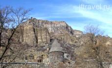
The Bohemian Switzerland National Park is the youngest of the four national parks of the Czech Republic. You will find it on the border with Germany, which separates “Czech Switzerland” from its twin, “Saxon Switzerland”. Millions of years ago the sea stretched here. Having subsided, it left behind a unique edge, which, being the lowest point Czech Republic, resembles mountains. This land of high sandstone cliffs and towers, rock arches, ravines and mountains with truncated peaks served as a refuge for ancient people more than 10,000 years ago. In the 13-14 centuries, German settlers began to build villages and entire future cities here; fortresses of knights grew on the rocks, who often engaged in robbery. In troubled times local residents they hid here from the armies marching through this region during wars, of which there was never a shortage near the historical border between the Czech and German lands. To this day, you will find here many reminders of these distant events - inscriptions carved on the rocks by the villagers themselves, reconciliatory crosses, rock chapels and abandoned church paths.
Photos: (Martin Rak,Václav Sojka)
Artists, poets and early travelers
The wild nature and hitherto hidden beauty of the region, which developed for a long time without human intervention, were discovered at the end of the 18th century by two Swiss artists of the Romantic era - Adrian Zingg and Anton Graf. Depicting this region in engravings and describing it in poetry, they spread its rapidly growing fame throughout Europe. The sites along the Elbe Canyon have become the cradle of modern tourism, becoming one of the first actively visited tourist attractions in Europe. More and more visitors flocked to the beauty and mystery of Czech Switzerland. One of the most famous landscape painters of all time, Caspar David Friedrich, also came here to obtain the motives for his paintings. The owners of the local estates understood the attractiveness of the local dense forests, as well as the romantic contours of the cliffs, and made a lot of efforts to make them as accessible as possible by building roads and bridges. On Mariana Rock, Welhelm's Wall and Rudolph's Stone, steps were made, benches were placed, and gazebos were placed on the tops. New taverns and places to stay overnight were opened for tourists along the roads, walking paths appeared, and the wild Kamenice River began to be used for movement between gorges.
Not only artists, but also famous poets, writers, and composers came to these virgin lands for their stories and legends. The fortresses of the robber knights, rocky places, legends about gnomes and fairies influenced celebrities, including the storyteller Hans Christian Andersen, the poet R.M. Rilke, composers K.M. von Weber, Richard Wagner and others.

Czech Switzerland in the memoirs of G.H. Andersen and R.M. Rilke
The poet R.M. Rilke visited Jetřichovice in 1892 and recalls his visit this way: “I want, dear reader, to take you to a land where mighty giant rocks reveal their gray giant crowns from a dark fir forest, and meadows strewn with flowers dreamily stretch along a babbling brook. …. Throughout the area, thousands of roads lead you deep into mysterious wilderness. Everything here attracts you to a sweet, carefree holiday - and even today. Long hollows with cushions of moss and a carpet of heather resemble purple feather beds, the trees look like a majestic canopy, and the tall fans of ferns are filled with blissful freshness.”
The passionate traveler Hans Christian Andersen even captured his impressions of the road from his native Copenhagen to the Czech Republic in the book “ Shadow paintings of a journey through the Harz and Saxon Switzerland". Emotionally and romantically, in the spirit of his era, he perceives both the country and the people he met along the way. He spent only a few hours in the Czech Republic, comparing it with the well-known tune that sounds inside us, full of life: “In my memories, this beautiful land spreads out, flooded with sunlight. I clearly see every detail of it, in my soul it is like a beautiful melody, despite the fact that I do not know how to express it in individual tones and motifs.
I see this large clearing in the forest with huge spruce trees, where we were told that we had just crossed the border, I see heavily tanned Czech girls with white scarves on their heads and bare feet, who we met in the dark spruce forest, and, finally, the pristine a section of the Pravchitsky Gate rocks, where we stood under a stone arch thrown over our heads by a mighty genius of nature. I see the vast dark forests somewhere below us are distant mountains with snow shimmering in the sun.”
Photo: (Václav Sojka)
And today the Pravchitsky Gate captivates artists, including the creators of fairy tales. Film director "The Chronicles of Narnia - The Lion, the Witch and the Wardrobe" found the ideal backdrop for his interpretation of this story in the snowy Quiet Rocks. Andrew Adamson chose Tisza because of the richness of the snow cover and the incredibly beautiful terrain with a natural labyrinth of rocks, which few people dared to enter without a guide back in the 19th century. Thus, he wanted to get as close as possible to the world that S.K. Lewis created with his imagination on the pages of books. It was here that Lucy visited the cave of the faun Tumnus, and all four siblings crossed the rock bridge for the first time and looked at the endless forests of Narnia.
The rock town of Til Walls and, in general, the whole of Czech Switzerland today are a real paradise for tourists and climbers. The first sporting forays to the tops of rocks took place already at the beginning of the 20th century. Since then, many climbing routes have appeared here. Climbing is possible to various mountain towers of the rock town with poetic names “Baldur’s Needle”, “Golem”, “Forest Drop”, “Stone of the Wise”, “Rudolfinum”.

© Martin Rak
The once quite extensive fortress of the 13th century two centuries later became the residence of Mikel Blekta from Utěchovice, who with his retinue carried out predatory raids on the surrounding area. At the end of the 15th century, the fortress fell into disrepair; from the 19th century, this place became accessible to the public.
 © Franta Kriváň
Sometimes also called the Robber's Fortress, it is one of the most beautiful rock fortifications in Czech Switzerland. Starting from the turn of the 14th and 15th centuries, it guarded the so-called “Czech Highway” - an important trade route connecting the Czech Republic and Lausitz. The owners of the fortress, the Berkovs from Dube, earned themselves an unflattering reputation as robbers, and the fortification itself served them as a refuge for carrying out robber attacks around. At the end of the 15th century, the site was abandoned and gradually fell into disrepair.
It's definitely worth climbing to the top of the fortress, not only to see the ruins of the fortifications, but also for the magnificent view that opens up at the top.
 © Ladislav Renner
At the top of the rock, many thousands of years ago there was a cave of ancient hunters. The fortress that originally stood here was built in the 13th century and gradually changed several owners, among whom was a robber knight, and was surrounded and burned several times. In the 17th century, hermits settled here and lived on the top of the rock for more than a hundred years. Later, Count Kinsky rebuilt the fortress into a country retreat for his guests. Among the visitors, the names of the Archdukes Franz Karl and Stephen of Habsburg, the Saxon king Frederick Augustus, and the future Emperor Franz Joseph I visited here with his brothers in 1847.
 © Jiří Stejskal
Over the centuries, the once Gothic fortress became both the residence of a noble family and the refuge of robber knights. The current ruins are still covered with many stories and legends. Here, supposedly, the ghosts of the White Lady and a large black dog appear, the dungeon is riddled with a labyrinth of secret passages, and in front of the fortress there is a spring, with the water of which particles of gold scatter; in the stream you can find rare and precious stones.
x 1 /On a boat to the very end of the world
One of the main attractions of Czech Switzerland, which, according to the authors of the book 501 Wildplaces, should in no case be ignored along with the Pravcicka Gate, is also a romantic boat trip along the Quiet and Wild canyons on the Kamenice River. It's a short but spectacular boat ride with a gondolier between two sheer cliffs - so deep in places that there is very little direct sunlight.

 © Tomáš Pavlásek
In Czech Switzerland there is the first observation deck in the creation of which man had a hand. From here you have a stunning view of deep canyon the Elbe River, as well as the Zirkelstein and Kaiserkrone mesas located in Germany. Once upon a time, concerts in the lap of nature were held at this site in Clari-Aldringen. By their order, a “terrena” hall was built, a small estate nearby and, somewhat later, a 4-kilometer path for carriages, then leading to their palace in the village of Bynovets. Nowadays this route is marked with tourist markers.
 © Václav Sojka
One of the largest natural rock arches on our continent, without a doubt, the most beautiful natural formation of Czech Switzerland and a recognizable symbol of the entire region at first sight. Since 1881, it has been inseparably linked with the Pravčicka Gate. summer estate"Falcon's Nest", originally used to accommodate honored guests of the Clari-Aldringen family. Today, the National Park Museum is located on the second floor of the building, and on the first floor there is a preserved stylish restaurant with the original design.
 © Vladimir Pešek
Maze length underground passages is 4,500 meters. At the end of World War II, they were laid by prisoners of the Flossenbürg and Rabstein concentration camps. The underground factory produced parts for aircraft, cannons, machine guns and aircraft missiles. Several dozen prisoners died during the construction of the underground factory. Today, the Concentration Camp Museum is located here.
 © Jiří Stejskal
A treasure of Northern Bohemia from the Baroque era, designed by the architect Johann Lucas von Hildebrandt. At the place of pilgrimage in the name of the Blessed Virgin Mary, which is already three hundred years old, liturgies and services are held in honor of the Procession of the Cross and the Holy Staircase.
 © Václav Sojka
With its expressive outlines and, above all, its elevation of up to 300 m compared to the rest of the terrain, it creates a clear dominant feature of the area. With an altitude of 619 m above sea level, the so-called Czech Fuji is the highest point National Park Czech Switzerland, and in the region Bohemian-Saxon Switzerland- the second highest mountain after Decin Snezhnik. It is likely that at one time pagan rituals were performed here, and there was also a place of pilgrimage. German tribes allegedly worshiped Ružov Hill as the abode of the gods. The motif of this mountain is noticeable in many paintings - for example, “Traveler over the Sea of Fogs” (Poutník nad mořem mlh) (1818) by the German artist Gaspar David Friedrich.
x 1 /This was once a serious obstacle that residents of local villages on the right bank had to somehow overcome when they wanted to get to the church on the other side of the river in the village of Růžová. At the same time, wood has been floated along the majestic river routes since time immemorial, and in winter, when the local waters were abundant with trout and salmon, they became a paradise for fishermen. Once in 1877, in the tavern “At the Green Tree” (U Zeleného stromu) in the town of Hřensko, five daredevils made a bet that they would sail on rafts from the Dolskaya mill to the place that was then called “the end of the world.” On floating structures 4 meters long, they actually safely reached Grzhensk, essentially becoming the founders of the tourist use of these waterways. Prince Clari-Aldringen invited specialists from Italy, under whose leadership, with the help of over two hundred workers, these areas became accessible to the public. Suspended walkways and bridges were laid here, and tunnels were built with the help of explosives. On May 4, 1890, the opening of the “Quiet” (“Edmond”) canyon took place in a solemn ceremony. Since then, “at the very end of the world,” in fact, nothing much has changed, the beauty of nature remains untouched, and the carriers, as more than 130 years ago, push and guide their boats with poles.
Photo: (Jerzy Strzelecki, Václav Sojka)
We learned about Saxon Switzerland quite by accident; Pasha came across an article describing a trip to Saxon Switzerland with impressive photos. I decided to see what it was and where. It turned out that the Saxon Switzerland National Park is located near Dresden, right on the border with the Czech Republic. And on the Czech side the park is called Czech Switzerland.
The park is not very large, but it has many trekking routes and you can easily spend at least a whole week. But thinking that a week of vacation is an unaffordable luxury, we decided that we would go to Saxon Switzerland one day just for a long weekend.
How to get to Saxon Switzerland?
The easiest way is by car. In this case, moving between routes and attractions in the park will be easy and convenient. The only downside is that the routes need to be planned either there/back or circular to get back to the car.
Getting there and moving around by public transport is also possible. On the German side the closest Big City- Dresden, from Czech - Prague. From both of them you can easily reach the park. But on the spot, in order to get to the beginning of routes from surrounding towns and villages, you will have to find out the schedule of local buses and trains.

Where to stay near Saxon Switzerland?
If you are by car, then this issue is not so pressing. From any village you can easily get where you need to go.

If you are traveling by public transport, then on the Czech side a good choice would be Děčín or Hřensko. Decin is larger, but from it you have to go to the park. But several routes start directly from Grzensko, including one of the most famous to Pravčická brána.

On the German side there are several options. If you want to visit the Bastei Bridge and take a walk in its surroundings, then best choice will be Rathen or Bad Schandau. If you want to walk along other routes in the park, then you need to choose one of the villages close to the route. Almost all of them have small family hotels where you will feel like a real German.

We had to stay for two nights, on a holiday weekend, plus we were by car and not tied to buses. Having looked at the options on Booking.com and Airbnb (we wrote more about what airbnb is in the article Airbnb - what is it? How to use it and how to book accommodation in any city?), we chose accommodation on airbnb in Decin, but for now we were thinking about this apartment already passed. Therefore, the next suitable room in terms of price, comfort and location was family hotel in the village of Ceska Kamenice.


What to do in Bohemian and Saxon Switzerland?
1 full day - Czech Switzerland
The route starts in the village of Mezni Louka and gradually gains altitude and goes towards Pravcicka Brana. Along the way there is a beautiful forest, rock walls, individual rock outcrops - in general, very beautiful!


Next is Pravcicka Bran and the 19th century building - Falcon's Nest. Login to observation platforms 75 CZK. On the official website you can check opening hours and current prices www.pbrana.cz. Most of it can be viewed for free, so it's up to you to decide whether to go to the paid part.


After this trail, you can go to Mezni Louki through the forest, or you can, like us, continue along the canyon. There is a second route Divoká soutěska and a second crossing - it will cost 60 CZK. We really liked the trail, it goes almost above the mountain river itself, sometimes overhanging it. Around beautiful rocks. On the first section there is a waterfall attraction - they take you to a wet wall, tell you some fairy tales, it depends on the boat manager, and then... suddenly a powerful stream of water falls from the waterfall like a fountain. Nobody expected this...


During the boat ride you will see not only a waterfall, but also beautiful wooden figures, each with its own story, you will be shown interesting rock formations that look like something or someone. The second part is less interesting, simply because it repeats the first. Although... Whether nature can repeat itself in such unusual forms is a controversial issue. From the end of the second trail, another 20 minutes and we go out to Mezni Louki, straight to the central parking lot. By the way, parking is the most expensive “entertainment” - 100 CZK / 1 day.


This route can also be taken from Grzensko. You can go in the opposite direction, but I don’t recommend this since the climb from Grzensko is long and monotonous, it’s much better to quickly descend there.
2 day or half day Saxon Switzerland and the famous Bastei Bridge
Most often, the route to the Bastei Bridge starts either at Basteistraße - in this case, parking will cost 3 €/day plus 1.5 €/person shuttle bus to the beginning of the route. The second option is the village of Rathen, almost all large parking lots are located in most of the village on the other side of the Elbe and you will have to take a ferry to get to the beginning of the route.


Only residents and hotel clients are allowed to enter the part of the Rathen village, which is located on the same bank as the Bastei Bridge. However, you can leave your car in private parking lots just before reaching the village. Cost 3€/day.

Before the start of the route, 15-20 minutes through a pleasant forest. At first, the signs took us to Basteistrasse; after looking at the prices, we returned to the idea that we would leave the car in the village itself. But... we saw a sign prohibiting passage to non-residents. There was a private parking nearby for 3€, but it was almost all occupied. There were cars parked nearby on the side of the road; there was no sign prohibiting parking. Of course we parked and headed to the Bastei Bridge.

Bastei is a group of sandstone rocks that, under the influence of time and nature, have taken on very beautiful and unusual shapes. Bastei is also famous for the Bastei Bridge. The Bastei Bridge was built in 1824 and was originally made of wood. In 1851 the Bastei Bridge was replaced by a sandstone bridge and it has remained that way to this day.

If you have at least 3-4 hours, then it’s worth visiting not only the Bastei Bridge, but also walking along the route further, going down to the Elbe and returning along the bike path to Rathen.

We were unlucky on the first evening, the weather was not very good, and as soon as we began to climb to the bridge it started to rain... Without thinking twice, we took a quick look at the bridge and went to our overnight stay. The second attempt was in the morning before going home. The sun was shining and the weather was just perfect. But we had very little time, so we limited ourselves to going to the Bastei Bridge and all the observation platforms and back. This route took us about 2-2.5 hours of a leisurely walk from the car. There is an optional paid section on the route, the cost is 2€/person. The route runs along footbridges between the rocks. There is a description of several historical details, although little remains of them. But beautiful views to the Bastei Bridge and surrounding rocks.

By the way, the most famous photos The Bastei Bridge is made with free viewing platforms. True, fog or beautiful sunset/dawn rays must be specially waited for. Although maybe you'll be lucky?!
As a result, I would like to say that if you are in the area and have 1-2 days free, then you should definitely stop by Czech and Saxon Switzerland!
Hello friends. Czech Switzerland. Quite a strange name, no matter what is hidden behind it, isn’t it? And hidden behind it is a Czech nature reserve, located on the border with Germany. On the other side of the border it passes into Saxon Switzerland. But the park is famous not only for its strange name. What else? Now we'll tell you.
It is believed that in the 19th century two Swiss were invited to undertake the restoration. They were very surprised when they discovered sandstone mountains nearby, which strongly reminded them of their native land.
Artists, peering at the rocks of a foreign country, painted Swiss landscapes familiar from childhood.
Thanks to these paintings, the place was called Saxon Switzerland. There is another version: the artists themselves gave the place this name.
Centuries passed and the border between Germany and the Czech Republic passed here. Part great places, remained on the territory of the state of Saxony, and partly on the territory of the Czech Republic.
The Czechs slightly changed the name and Czech Switzerland (České Švýcarsko) appeared. The name stuck.
Since 2000, this area has received the status of a national park.
Bohemian Switzerland National Park is its official name.
Attractions and entertainment of the park
- The symbol of the park can be called the Pravčická brána - this is the largest natural mountain arch in Europe.
It cannot be reached due to the possibility of collapse, but you can admire it from one of several observation platforms.

The most famous of them is called Belvedere. It hangs over the Elbe Canyon.
- Near the Gate there is a hunting castle “Falcon's Nest” or Zámek Sokolí hnízdo.
It was built in the 19th century. Now it houses a museum, as well as a restaurant with original interior decor.
From big gate you can reach the small ones. They are called the Small Pravchitsky Gate.
Near the Small Gate you will see a sign leading to Schaunstein Castle.
- Move on. There you will see the Dolsky Mlin mill.

Now all that remains is mostly ruins.
And next to it is the Ferdinand Gorge, which received its name in honor of Archduke Ferdinand.
Elsewhere in the Czech Republic, the castle of Archduke Ferdinand has been preserved, where everything is still maintained as during the owner’s lifetime, and in the beer hall you can try the “7 Bullets” beer, based on the number of bullets that killed the Archduke and his family. The humor is black and bitter, and many people praise the beer.
- Another attraction of this area is the village of Khrzhensko.
It is famous for the fact that it was on its territory that a glass workshop previously functioned, where Bohemian glass was made since the 15th century.
You can visit it now to get acquainted with the accounting books of those times, see how glass is blown, or even buy something for yourself.

- Another offer for adventure lovers is an excursion to abandoned silver mines.
Here you can go down to find out how the miners worked, or climb higher into the mountains and get acquainted with Falkenstein Castle, located right in the middle of the rocks.
But all that remains of Tolštejn Castle are ruins. But from its walls there is a stunning view of the park.
- Another castle that still impresses with its size is Decin Castle.
It was a military fortress and residence for local aristocrats. European artists and even monarchs often visited here.

- If during the tour you miss the legends, go to the Wolf Board.
This is a stone slab with a story carved on it about a hunter who killed two wolves at once.
The mountains here may be small, but they are still mountains. Here you can go mountaineering, trekking, and rafting.
Unprepared tourists can feel like real rock climbers, although only with special equipment and an instructor.
The entire park is intertwined with many equipped walking paths. They vary in complexity and length.
There are special routes for bicycle fans.
Even though you are in Czech Switzerland, there are gondola excursions here.
They pass along the Kamenitsa River and two gorges: Quiet and Wild.
Another way to test your physical fitness is to walk along the Mouse Hole.
Despite the name, this place has nothing in common with mice. This is a narrow staircase leading to the top of the cliff. It was built on the initiative of Prince Ferdinand Kinski.
This video is longer, but also more beautiful:
Where to Stay in the Bohemian Switzerland National Park
Now many housing options have appeared on the service AirBnb. We have written how to use this service. If you do not find a free hotel room, then look for accommodation through this booking site.
We offer good hotel options in Czech Switzerland
How to get there
The best thing rent a car and do not use trains or buses. Driving around the Czech Republic is pleasant, plus you are not tied to schedules.
- From Prague
To get to this corner of the Czech Republic and explore the romantic ruins among the mountains and mines, you need to get to Děčín, the city closest to the park, from Prague Mosarikov Station.
From Decin it’s another 20-25 minutes by bus to Grzensko. You can also rent a bike there.
You can take a taxi - this is the most beautiful way. You will need to drive along the Elbe riverbed.
Don't be afraid to come here in winter. The waterfalls in the ice are simply amazing, as are all sorts of bizarre rocks, rare plants and other riches of this region, which we have already talked about.
- From Dresden
It's even faster to get there from Dresden. By car on route 172, after the castle, you need to get to the other side near the city of Bad Spandau. When you cross the border and enter the Czech Republic, highway No. 172 will turn into highway No. 62. Drive a couple of kilometers and turn left. Everything, in Czech Switzerland.
Saxony is famous for its works of art, luxurious city architecture, and ancient castles. Also this one amazing land rich in beautiful nature and cozy resort towns. On every trip we try to diversify the program. We decided to devote the second day of our trip to Saxony to natural attractions. The main purpose of this day is to visit national parks Saxon and Bohemian Switzerland.
Read the route of the first day in Saxony here:
Saxon Switzerland is located just 50 km southeast of Dresden and 80 km from Meissen. And again here I will tell you about the advantages independent travel. They stop by in Saxon Switzerland, on the Bastei Bridge tourist buses on the way from Prague to Dresden. But Czech Switzerland is unknown tourist site for organized tourists. Mostly independent travelers arrive in the town of Hřensko, the starting point on the route through Czech Switzerland. We have combined these natural parks into one day route. The road passed through the town of Pirna, where we stopped for an hour. But first things first.
Route of the second day in Saxony.
Meissen - Pirna - Saxon Switzerland (near Lomen) - Bad Schandau - Czech Switzerland (near Hrensko) - Decin (overnight).
Pirna is a cozy resort town.
The first stop on our route was the city of Pirna. The town is located 25 km southeast of Dresden on the banks of the Elbe River. Excellent German road We didn’t notice how we arrived in Pirna.

First of all, we look for where to park the car. I really liked the organization of parking in this city, as in Germany in general.
Plenty of parking spaces in the center, next to the Old Town. There are open parking areas, but we chose level parking. It’s interesting that instead of a restaurant or hotel in Pirna, a 4-story parking lot was built for about 80-100 cars.

Parking rates are affordable.

Everything inside is compact.

When we returned, we paid for parking at the cash machine at the entrance.

To pay for parking, we inserted a parking ticket into the slot, which we took from the machine at the entrance (pictured on the left). We paid at the cash machine in cash. As a result, we received a receipt for payment. (pictured right). When leaving, it was inserted into the slot of the parking machine.

Walk through the Old Town of Pirna took us about 1 hour. But this time was enough for us to fall in love with the town. We would love to stay here for a few days. Well, how can this not impress?! home Marktplaz area.

Pirna- a surprisingly colorful ancient Saxon trading town. It is already about 8 centuries old. Viewers of the popular German TV channel MDR named Pirna the second most beautiful city in Saxony. Many tourists come to this resort town. Pirna is called the gateway to Saxon Switzerland, a national park with many hiking, mountaineering and cycling routes. There are many ancient castles near the city. There is a water park in Pirna called Geibeltbad Pirna with swimming pools and saunas for relaxation after an active holiday.
Pirna is famous for its good wine. The Saxon Wine Route tourist route begins from this city, runs along the Elbe and ends in (the town we talked about in the last article).
There is a lot of choice in Pirna good hotels, apartments, guest houses, What to find and book accommodation, just follow the direct links below:
For profitable special offers and promotions of Pirna hotels, see the form below:
Pirna is also known as a global supplier of sandstone. Many buildings and sculptures in the city are made from this stone. For the first time in the world, sandstone even became a material for a modern local playground. Saxon sandstone blocks from Pirna were supplied in ancient times and now also to many countries around the world. Famous European imperial palaces were built from stone quarried in Pirna. For example, the luxurious palaces, sculptures and churches of Dresden. Slogan modern city“Pirna – Sandstein voller Leben”, which means “Pirna – sandstone filled with life.”
We head along the shopping street from the parking lot to the Old Town of Pirna. The resort is just waking up. Some shops are still open.

Very original and cute souvenirs.

Let's go to main square Old Town (Altstadt). It's called Marktplatz, which means "market square". Since ancient times there have been shopping malls here. Interestingly, the Old Quarter was restored relatively recently - in the 1990s. Many buildings were damaged during Allied bombing in 1945. Pirna was heavily damaged by floods in 2002 and 2013. But after being flooded by the waters of the Elbe, the city was put back in order again. Around is the traditional German “ordnung”. Everything is somehow “elegant and gingerbread”, a very pleasant atmosphere.


There is an old well on the square with water flowing from the tap. We don’t know if it’s safe to drink, but it can be refreshing on a hot summer day))

In the center of the square rises Town Hall. She's on the left in the photo. The building was built in 1396. For many centuries, the Town Hall was a place for trade. Here were the shops of merchants, shoemakers, clothiers, and bakers. It is now a city administrative building.

Above the main entrance to the Town Hall there are ancient sundial and coat of arms of the city of Pirna with red lions and golden pears on a tree.

On the other side of the Town Hall, a beautiful clock with a golden-black dial is clearly visible. They also have a lunar calendar and the phases of the moon are depicted. Under the clock is the coat of arms of the city of Pirna from 1549, and below is the old Saxon coat of arms from 1555. They are both made of the city's emblematic stone, sandstone.

White building Canalettohaus with a pointed Gothic roof and windows, it was built on the square in 1520. The house is named after the medieval Venetian landscape painter, court artist of the Saxon Elector Frederick Augustus III Bernardo Bellotto, known as Canaletto. He painted city landscapes. He liked Pirna so much that the artist dedicated 11 paintings to her in 1753-55. Some of these works are presented in the Dresden Gallery.

In this picturesque house on Marktplatz there is now an exhibition of copies of paintings by Canaletto and tourist centre. In it we took free card city, along which a further walking route around Pirna was built.

There is a very tragic and terrible moment in the history of Pirna. It is connected to the castle, which rises on a hill above the Old Town. It is clearly visible from many streets and from central square. In the photo - high on the right behind the white Canaletto house. We don’t plan to go up to it, but we will tell about its tragedy.
This is Sonnentscheit Castle, its name in German Sonnenstein, literally translated as “sun stone”. The castle was built on the mountain in the 13th century. From 1811 to 1942 it housed a psychiatric hospital.
During the Second World War, Sonnenstein Castle became a testing ground where methods of mass extermination of people were developed. It all started in 1934 after the National Socialists, led by Hitler, came to power. At that time, the ideas of “racial purity” were embodied in the country. How unfit people were sterilized or killed, people suffering from hereditary, mental, serious illnesses, and disabled people. Officially, the process was called “euthanasia” or “death for good.” This was done in several treatment centers and psychiatric hospitals in Germany. Among them was Sonnenstein. The methods were different: patients were starved, given drugs in large doses, and lethal injections were given.
The Sonnenstein psychiatric hospital was one of the first to launch the “T-4 death program” and began mass extermination of sick people in gas chambers. The crematorium ovens were also built here. In two years, from 1940 to 1942, almost 15 thousand people were killed here, more than 1000 of them prisoners of war. After such “tests,” gas chambers for “racial cleansing” were installed in Auschwitz and other concentration camps. In 1947, the chief physician and orderlies of the Sonnenstein Hospital were sentenced to death.
Since 1970 he has been working in the castle rehabilitation center for invalids. And since 2012, after reconstruction, individual halls and the garden of Sonnenstein Castle are open to visitors. In the photo, on the horizon at the end of the street you can see a castle on a hill. 
From Markplatz we headed towards the main St. Mary's City Church This is a large, beautiful Lutheran church, built in 1546. Its 60-meter Gothic tower is visible from afar.

Inside the church there are unique sights from the 16th century: the original 10-meter stone altar, a stone baptismal font with 26 miniature sculptures of children. They are created (like the entire temple) from local sandstone. Also in the Church of St. Mary are paintings from 1544-1546 with scenes from the Bible and an ancient organ. The church hosts classical music concerts.
It is clear that the town is a resort - it wakes up late. We were unable to get into St. Mary's Cathedral. It turned out that it opens only at 11-00. The morning resort of Pirna, along with shops and cafes, is just waking up (and this is at 10! in the morning).
The main entrance to the city's St. Mary's Church.

A walk along Pirna in the morning is very pleasant. Tourists are just waking up and you can enjoy the almost deserted streets and squares of the city. There are many old houses around. Each of them has its own history and keeps its secrets.
The old building in the photo on the right is now a restaurant, and in the Middle Ages, from 1578, there was a pharmacy “Golden Lion”.

Above the entrance to the house there is a figure of a golden lion and a memorial plaque. It is dedicated to the hero of Pirna - the city pharmacist Theophilus Jacobaer. It says: “T.H. lived here.” Jakobaer - the savior of our city on September 25, 1659." During the 30 Years' War, Swedish troops captured Pirna - they robbed, destroyed, and abused the inhabitants. They planned to burn the city. The pharmacist, having learned about this, went to Dresden and through the court appealed to the Saxon princess Magdalena, a friend of the Queen of Sweden, with a request to cancel the decision to destroy the city. Pirna was saved, and Theophilus Jacobaer became a hero and received privileges in the pharmaceutical and brewing business as a reward.

The city library of Pirna is housed in an old house from the 17th century. Above the entrance is a lion's head portal from 1770, carved from Saxon sandstone.

You can see exquisite old balconies on many buildings in Pirna. They have been preserved since the 16th and 17th centuries.

And in this house, on the way to the Marienbad resort, the famous German poet Goethe stayed in April 1813. In 1925, the leader of the German communists, Ernst Thälmann, gave a speech.

This original monument was recently installed in Pirna. It is dedicated to the most outstanding citizens of the city in its entire history: the burgomaster, the first bishop, the trumpeter, merchants, ordinary people who did their job every day.

The interesting City Museum of Pirna is housed in the ancient building of the Dominican monastery, founded here in 1300 (address: Klosterhof 2/3).

The Dominican monastery and church of St. Henry were restored and became operational for parishioners in the 1990s.


The tall stele was erected in Pirna by order of Elector Augustus the Strong in 1722. It bears the coat of arms of the royal family. By the way, she is depicted in Canaletto’s paintings. On this pillar are engraved the ancient names of various German cities and the distance to them from Pirna in hours. 1 hour is equal to approximately 4.5 km. For example, the German town of Annaburg is 25 hours, or almost 112 km. The distance to Meisen, where we came from today, is 17 hours or 76 km. An interesting system for measuring distances))) Everything is logical, the most practical information at that time about the amount of travel time. Why these kilometers in the 17th century)) 
The Germans care about the environment; electric bicycles have been added to electric vehicles. Here is a free charger for such bikes. 
Getting to know the cozy resort town Pirna left a warm impression. And we are heading to the natural attractions of Saxony. We crossed the bridge. Along the way, we look at the modern part of Pirna, already on the other bank of the Elbe. 
Saxon Switzerland. Bastei Bridge.
Saxon Switzerland is a national park with a stunningly picturesque mountain landscape 30 km southeast of Dresden. It occupies an area of 9.5 thousand hectares on the border of Germany and the Czech Republic. Its neighbor is the Czech Switzerland National Park. Both parks are part of the Elbe Sandstone Mountains, which are part of the Eastern Ore Mountains.
Where does this name come from and what does “Switzerland” have to do with it? Until the 18th century, this area was called the Meissen Plateau. Swiss artists Anton Graf and Adrian Tsing, who taught at the Dresden Academy of Arts, chose these places. The mountainous area above the Elbe with gorges, waterfalls and ancient castles reminded them of their native Switzerland and the Jura mountain range. Hence the name “Saxon Switzerland”.
We came here for such beauty))) 
In the 1800s, Swiss artists traveled here themselves and invited other landscape painters for inspiration and beautiful views. Masters of brushwork and photography still travel to Saxon Switzerland today. Throughout the park, through all the main natural and architectural attractions, one of the most beautiful tourist routes in modern Germany, Malerweg, which means “Artists' Trail,” stretches for 112 km. It offers the most breathtaking views of the surrounding landscape. Interestingly, in 2016 it was included in the top three most popular routes in the world.
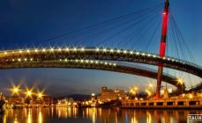
In the 18th century, following the artists, tourists and climbers flocked here. Shops, a restaurant, and a hotel were opened for them. In 1824 they built between the rocks famous bridge Bastei. Today it is one of the most popular attractions in Saxony.
The most convenient way to get to the Bastei Bridge is by car, you can also do this by S-Bann train to Raten or Wehlen, by bus from Pirna (No. 237, 238) and Bad Schandau (No. 253), or in the summer by boat from Dresden. If you are traveling by car, it is easier and faster to get to the Saxon Switzerland park through the town of Lohmen. That's what we did.

Following the signs, we drove into the parking lot near the main entrance to the park. Parking costs 3 euros. Entrance to the Saxon Switzerland park is free. The fee is charged only for walking through the remains of the 13th century Neurathen fortress. These are bridges between the mountains beyond the Bastei Bridge. The price for 4 of us is 12 euros.
Helpful advice: for a walk in Saxon or Czech Switzerland is a must comfortable clothes, buried shoes, water, and in summer a hat is advisable. Even though it was hot, we all changed into sports sneakers. There are many rocky trails in the parks.
Next to the parking lot is the entrance to the Saxon Switzerland National Park. There are information stands with maps and information about the park in different languages.


We turned off the main road onto a side path. Such a breathtaking panorama opened up. Mountains of such an elongated shape with a flat top and steep edges are called table mountains. One hundred million years ago, during the Mesozoic era, this place was ancient ocean. The sand settled to the bottom hundreds of meters and in several layers. When the ocean waters left, volcanoes split the sandy bottom into many parts. The formation of the unique landscape was completed by water and wind.

The main path led us to the hotel, souvenir shops and restaurants. In 1812, the first restaurant was built near the Bastei Bridge, and a little later - the Berghotel Bastei. This hotel has a rich history and an excellent reputation. Today the Berghotel Bastei is the winner of numerous awards. It is considered one of the best in Saxony.

There is even a service for dogs)))

Behind the restaurant and hotel there are several rocky trails with many steps, all equipped with handrails. Even though you walk between the peaks of the mountains, you feel safe (this is information for those who are afraid of heights))). And if you look down and around, the unreal beauty will take your breath away.
First of all we went to observation deck with stunning “postcard” views. It is located on a high cliff that rises 194 m above the Elbe. This is what we dreamed of seeing when we were planning our trip!

The people on the site are like sardines in a barrel. We made our way to the railing. A “dream photo” against the background and alone is a rare success here. And this is on a weekday. Where would we be without the “pink blouse” in the background))).

In the distance is Mount Lilienstein, the largest table mountain in Saxon Switzerland. To the right of it, on a smaller mountain, rises the Königstein Fortress, a powerful fortification structure of the 12th century. At different times she served as defensive fortress, monastery, prison, prisoner of war camp and storage site for paintings at the Dresden Gallery during the Second World War. In Konigstatt, a prisoner of the fortress, the alchemist Johann Betherr, imprisoned there on the orders of Elector Augustus the Strong, invented the first European porcelain in 1709. This began the production of the now famous Königstein Fortress, a popular tourist attraction in Saxony.

The picturesque bend of the Elbe. Below you can see the ferry crossing and two shores of the city - the resort of Rathen. This small ancient town is a climatic resort. Here is the cleanest air, a calm atmosphere, the unique nature of Saxon Switzerland with mountains, waterfalls, Lake Amselsee, a rhododentron park, nearby the ancient fortresses of Königstein, Stolpen and Lohmen, waterfalls, the Bastei Bridge, the Miniature attraction Railway", summer Rathen theater among the rocks.

The ferry in Rathen is a unique, environmentally friendly form of transport that still operates using technology invented by the Dutch back in the 17th century. It moves without a motor and without polluting exhaust gases. This is a cable ferry. It is held in place by a long cable that stretches several hundred meters upstream along the river and is anchored near the shore.
The ferry runs regularly from one side of Rathen to the other. This is convenient for independent travelers who come here by train. by boat from Dresden or stop at hotels in Rathen. To get from Rathen to the Bastei Bridge, you need to cross the Elbe by ferry. A ferry ticket costs 1 euro (children: 0.50 euros) one way, round trip - 1.80 euros (children: 0.80 euros). Further along the famous “Artists' Trail” you need to climb to the Bastei Bridge. The climb up the steep path with many steps can take 30-60 minutes, depending on your fitness.

And we continue our walk along the paths and steps of the park. Another bridge and a wonderful panorama of Saxon Switzerland.

Does the color of these mountains remind you of anything? The famous noble shade of palaces and churches! They were built from Saxon sandstone, which was quarried in the area. Stone mining proceeded at such a pace that the existence of Bastai and the surrounding area was threatened. In the 18th century, people stood up to protect the unique mountains. Nature reserves were gradually created, and after the fall of the Berlin Wall and the unification of Germany, this territory was united into the huge Saxon Switzerland National Park, and in the neighboring state - the Czech Switzerland National Park. Now the original natural landscape is protected by the state, and sandstone mining is regulated by law.

The famous Bastei Bridge rises 40 meters above the gorge. Its 7 arches fit organically into the mountain landscape. The length of the bridge is 76.5 m - such a long observation deck with magnificent views of the surrounding area! The first wooden bridge was built on this site in 1924. Over time, it became dilapidated and it became dangerous to walk on the planks. Within two years in 1854, a new stone bridge was built from local sandstone. 
The Bastei Bridge is one of the most visited attractions in Saxony. There are always a lot of tourists here.

The original round observation deck on the bridge. Miraculously we took pictures without tourists in the background))


There are memorial plaques on the rocks.


On the other side of the Bastei Bridge - behind a wooden palisade are the remains of Czech castle XIII century Neurathen. (The entrance fee here is 3 euros). He guarded the borders of the Czech Republic and trade routes on the Elbe. It was one of the biggest impregnable fortresses that time. It occupied an area 700 m long and 100 m wide. flat tops of rocks connected by bridges made of logs, fortifications were built. There was also a drawbridge here. The castle was destroyed by fire in 1469. In 1485 it passed from the Czech Republic into the possession of the Saxon Margraviate of Meissen. Now practically nothing has survived from it: the remains of walls, an ancient water storage facility, a catapult and large stone cannonballs that were once fired at enemies from the heights of the fortress.
The paths of the castle of the Neurathen fortress (pictured on the right) offer amazing views of the surrounding area. 
Beautiful pictures of the nature of Saxon Switzerland and from the Bastei Bridge.


Saxon Switzerland is very popular among climbers. Can you see the climber? 
And he is))

Although there are a lot of tourists here, so sometimes there was a traffic jam on the paths, the park is definitely worth a visit. Saxon Switzerland is very cozy, beautiful and unusual.
We are moving towards the next destination of today's route - Czech Switzerland. The road passes through the resort town of Bad Schandau. It is known for its excellent rehabilitation and health resorts, Wellness centers, healing thermal baths, good resort hotels. Interestingly, Bad Schandau is the smallest city in the world with a tram. Also in Bad Schandau (Dresdner Str. 2 B) there is information Center National Park Saxon Switzerland. This is an interactive exhibition that tells about the flora and fauna, history and modernity of the park.
We enter the city of Bad Schandau.

The road runs along the Elbe.

We stopped at a local supermarket and bought German beer and goodies at good prices. For example, a 0.5 liter bottle of the famous Saxon beer Radeberg costs about 0.50 cents. For comparison, a bottle of Coca-Cola is twice as expensive)) 
This is the view of the Elbe from the supermarket parking lot.

And here we are again in the Czech Republic. Former checkpoint on the border between Germany and the Czech Republic. Now the Elbe is changing its name - it sounds in Czech “Labe”))) The road here is very picturesque: on one side there are the waters of the Labe River, and on the other the cliffs of the Elbe Canyon rise.

Czech Switzerland, or lost in the Lost World.
On the border with Germany lies an equally beautiful “neighbor” of Saxon Switzerland - the Czech Switzerland National Park. This is part of the Elbe Sandstone Mountains in the Czech Republic. Stunning nature, a unique mountain landscape, deep gorges, caves, clean air, silence, many hiking and cycling routes, ancient castles and authentic houses, fabulous sculptures and local legends - this is what Czech Switzerland is rich in.
We arrived at Hřensko (Grensko, Czech Republic). It is called the gateway to the Bohemian Switzerland National Park. The town is located 55 km from Dresden, 130 km from Prague, 40 km from the Bastei Bridge in Saxon Switzerland and only 10 km from the town of Decin, where we plan to stay overnight.
What is unique about Grzhensko: This is the lowest area in the Czech Republic. The city is located only 115 m above sea level, although thanks to the surrounding cliffs, it does not feel that way. The nature and climate around Hřensko are also unusual - mountain plants thrive in the lowlands. What adds to the exoticism is that there are more Chinese in this town than local residents. What are the Chinese doing here? And they sell souvenirs and Chinese clothes.

Grzensko consists of practically one street along the small river Kamenice, which flows into the Labe.

The architecture of the ancient houses of Grzhensko is very colorful. Next to the luxurious palaces and hotels of the 19th century, here under the overhanging rocks there are neat older rural houses.

The town was founded here in the 15th century. A large Czech trade route ran along the Elbe. At first, on the site of Grzhensko there was a tavern, where merchants and tree raftsmen came to rest and refresh themselves. Later, workers built huts near the storage facilities for grain and wood, salt and glass. Since the 17th century, Grzensko became a large trading city. In these places they harvested and processed wood, ground grain in three large mills, mined sandstone, traded mushrooms, salt, charcoal, and even smuggled goods. In the summer of 1838, the first steamships began to ply along the Elbe.
On the left in the photo are the ancient buildings of Hřnesko and the Church of St. John of Nepomuk, built in 1787. 
Only in the 19th century did the enterprising owner of the lordship, Prince Edmund Clary-Aldringen, realize how attractive his land was for tourists. He began to actively develop the tourist destination. In the 1830s, hotels and inns were built in Grzhensk. In 1862, a company appeared in the city that sold photographs and postcards with the sights of Hřensko.
In 1879, the Mountain Community of Bohemian Switzerland was created. Its members built and equipped hiking trails and observation decks with railings, steps, benches, bridges, also published popular magazines, and held meetings. In 1898, two gorges with boat crossings opened to visitors. During World War II, a branch of the Hitlerite aircraft factory operated in the adits of Grzhensk. The town and park Bohemian Switzerland were revived for tourists after 1964, when the trails and gorges were reopened after reconstruction.
One of the famous attractions of the park is Pravcicka Gate, or Pravcicka Braná, in Czech - Pravčická brána. This is a huge sandstone arch, which was formed millions of years ago by natural “sculptors” - volcanoes, water, wind. Her maximum height 21 m. The 8-meter arch bridge connects two sand mountains. The trail to Pravčicka Brana has been open to tourists since the 1830s. Interestingly, the famous storyteller Hans Christian Andersen climbed here.
Nearby is the Falcon's Nest castle, built in 1881. The former summer residence of Prince Edmund Clary-Aldringen, the founder of the tourist destination in the development of Czech Switzerland. The castle was erected within a year by Italian craftsmen on the site of a wooden pub. Now there is a National Park Museum on the second floor, and on the first floor there is a restaurant in which the original wall paintings have been preserved. The Pravčicka brane offers a wonderful view of the surrounding area.

Many sources claim that this is the largest “natural bridge” in Europe and the world, but we have seen more on. On about. Gozo has the Azure Window. The stone arch rises 28 meters above the sea. The numbers sound dry, but nothing can compare the delight and surprise when you see such an incredibly powerful and majestic natural structure nearby.
 Malta, o. Gozo, Azure Window
 Today we had already admired the mountain landscape from the Bastei Bridge in Saxon Switzerland, so for a change we decided to take a walk in the remaining half day along the bottom of the gorge Edmund And go boating on the Kamenica River.
Practical information about Czech Switzerland:
Required: comfortable clothes, closed sports shoes, a hat in summer, and bring water with you.
Entrance to the Bohemian Switzerland Park is free. For boats and Brana, payment is accepted in crowns and euros.
- Pravčická brána
Price walks along the paths and observation platforms of Pravcicka Brana - 75 CZK (3 euros) - adult, 25 CZK (1 EUR) - child ticket.
- Edmund's Gorge
Working hours: From April to September the boats operate from 9-00 to 18-00, in October - from 9-00 to 17-00 every day. The last boat in the direction of Grzhensko leaves at 18:00, and in the direction of Mezna at 17:30. (in October, accordingly, an hour earlier)
Riding cost on the boat: 80 CZK (3 EUR) - adult, 40 CZK (1.5 EUR) - child ticket.
- Wild Gorge
Working hours: From April to September from 9-00 to 17-00, in October from 9-00 to 16-00 daily. The last boat in the direction of Grzhensko leaves at 17-00, and in the direction of Mezna Luka - at 16-30. (in October, accordingly, an hour earlier)
Boat ride price: 60 CZK (2.5 EUR) - adult, 30 CZK (1 EUR) - child ticket.
How to get to Hrzensko by public transport: Regular buses go here almost every hour from Decin (the journey takes 15-20 minutes) and Bad Schandau. They can also take you deeper into the park, to the villages of Mezhna or Mezhni Luka, from which hiking routes around the park begin. You can also travel by boat from Decin, from the German cities of Bad Schandau, Dresden and Meissen. And these cities can be easily reached by train.
Buses run through the park, stop locations are marked on the map with a BUS sign.
Parking: There are 4 municipal parking lots and several private ones in Hřensko. All of them are shown on the map. Parking cost: 30 CZK (1 EUR) per hour, 120 CZK (4 EUR) per day.
Hotels in Czech Switzerland: There are hotels and guesthouses in Grzhensko and the surrounding villages of the park. At the same time, you will stay in the very heart of Czech Switzerland and will be able to enjoy nature, tranquility, and engage in active hiking and cycling tourism. You can book your accommodation using this link:
See also special offers with discounts for hotels in Czech Switzerland.
Here is the most difficult moment for those who are traveling to Czech Switzerland for the first time. And if everything is certain with Pravcicka Brana (except for the travel time), then with the gorges we “got it”. We will show you all the optimal walking routes on the map. In the meantime, let's talk about our adventures in Czech Switzerland. We named them "Lost in the Lost World."
We parked the car in the first parking lot. A pleasant woman, the ticket taker, who understood Ukrainian perfectly, gave us a map of Czech Switzerland. We warned that we were parking for 2 hours. (Judging by the map... Oh! Optimists.!))) She smiled and said that this was not enough, but you can pay extra for parking later.
Here is the map of Czech Switzerland that we received. It is in German and Czech.

When we were planning a route through Czech Switzerland, we read reviews from other travelers. Many walked in a large circle: from point 1 - through all the points - to point 6. Everyone wrote that the walk takes a lot of time, but no one said anything specifically, it looked something like this: “I walked, I looked.” The only thing they wrote was that everything was done in a day. But since we arrived after lunch and were in the mountains of Saxon Switzerland, we decided not to inspect point 2 (Bram). We wanted to walk through the city of Gzhensko from point 6 (parking) and take a boat ride in the Edmund Gorge between points 5 and 4. And then return along the same route or walk to the stop in the village. Mezhnaya and come to the parking lot by bus.
"Pitfalls" of thisarts .
- It does not mark where the ascent or descent is, which is inconvenient when planning a route.
- The distance in km is shown only on highways, and the length of ALL walking routes measured in MINUTES, not meters or kilometers. This is where the “trick” comes in.
Practice has shown that walking along the route actually takes at least two to three times longer than what is written on the map. Also keep in mind that on the way you will spend a little time taking photos - pauses, because there is amazing beauty all around.
3. How does a person feel when expectations are disappointed? Unpleasant feelings of confusion, fatigue from waiting and irritation from the fact that in reality everything is not so. These are our feelings during the second half of our route, when the information on the map did not coincide with reality at all. That's why we were "Lost in the Lost World"
And now everything is in order. Our example of which route not to take. “Don’t go there, don’t go to court”)))
Grzensko is an interesting town. We walked along its only street with pleasure, looking at the houses and funny garden figurines that were sold along the road.

We're excited. Behind the bridge and the Pension Soutěsky hotel (on the right in the photo) a beautiful trail to the gorge begins. The car could have been parked here, but this way we got a better look at Hřensko.

At the beginning of the trail there is an information stand with a map, distances, boat operating schedules and their last departure, so that the tourist does not walk in vain. Everything is written optimistically))) Here you can see that the first yellow section, 1 km long, takes 20 minutes. In city mode we walk faster. But something went wrong here. We walked it to the gorge and the boats in 50 minutes (this is true from the parking lot, 1 km from it).

We crossed the bridge over the Kamenice River.

After it the forest path begins. It is equipped with railings, steps, benches.

Interestingly, until the 19th century, the mountainous area with gorges along the Kamenitsa River was called End of the world. When the trails ended, local residents were afraid to go further into the dense forest, full of secrets and legends. Well, what’s not fabulous lost World?!


It's incredibly beautiful all around.

Here you want to sit down and just enjoy the tranquility, the murmur of water, the singing of birds, the greenery of the forest in the sun’s rays.

But the forest path along the stone gorge along the river does not end.

Well, finally we can see the landing site for the boat. Further on the trail is interrupted and you can only move along the route by water.


The history of these boats and the Kamenitsa River gorge began with a dispute. In 1877, five daredevils, having had a good drink in the Grzhensky tavern, made a bet that they would float down the stormy river on rafts. The three rafts confidently covered the distance. After this, the owner of local lands, Prince Edmund, hired Italian workers and built paths, bridges, tunnels, and dams. In 1890, boating along the first gorge, 500 m long, opened for tourists. At first it was Quiet, now it was named Edmund Gorge in honor of the prince. A few years later, a second gorge was built, the Wild Gorge, the length of the route along it is 250 m. Then tourists were taken on boats by ferrymen in beautiful sailor uniforms.
Today we will sail along the first long Edmund's Gorge. We bought tickets at the box office. Tickets for our family cost 9 euros. The walk takes only 20 minutes.

We ask the cashier what we should do, how far and how long after the boat to point 4 - p. Mezhna? He says no, it’s close there. Indeed, on the map there is a zigzag drawn on the green left route and it says 15 minutes. We had two options: 1. Go back by boat, again pay 9 euros and again walk 50 minutes to the parking lot. Or 2. -see more of Czech Switzerland. We chose the second option: after the boat, walk 15 minutes and 500 m (according to the map) to the village of Mezhna, take the bus there and return to the parking lot. (You could also go further along the yellow route, take a boat along the Wild Gorge and go to the village of Mezhni Luka and the bus, but it would be much longer).
The boat ride was very nice and soulful. The boatman told funny and cheerful stories about the gorge and mysterious legends in three languages (English, Czech, Russian).

Local fairy-tale residents looked at us from the shores. Good and not so good))


And where there were no sculptures, everyone unanimously turned on their imagination. After all, the outlines of rocks and stones are very similar to fairy-tale characters.

Do you see the snake?

The boatman pulled the rope and a waterfall poured down from the walls of the gorge. I pulled it a second time - there was no waterfall.

The walk turned out to be interesting. We sailed to the boat station. There is a restaurant on the pier. Here you can have a snack and relax.

Prices in Czech crowns.


On the way we washed ourselves and cooled off in the river.

The path leads through the tunnels.

These tunnels were cut into the rock by workers specially invited from Italy. They were called Barabbas. They were famous masters mining operations in the Alps. A special technology was used in the formation of the tunnels - in winter the rocks were heated, then cooled sharply with water. So the stone walls cracked and could be processed.


This place reminded me of another stone gorge in Austria - Liechtenstein. Read about it here:

It turned out that a rise was awaiting us, remember the zigzag on the map? It was not an easy climb, but a very steep and long one. It felt like we had climbed a skyscraper. And we walked serpentinely along such stairs.


Well, we think, we’ll be patient, we’ll get on the bus soon. But when the stairs ended, the ascent continued along forest paths. 15 minutes have long passed, but the end of the edge is not in sight)) We looked around, there below was the gorge of the Kamenitsa River. 
And when we finally reached the village of Mezhna, to the restaurant, our strength completely left us. The time from the boat station to this finish took again 50 minutes. It took 30 difficult and long-feeling minutes to get up, but 15 were announced. 
Judging by the map, there should be a bus stop here. But the restaurant waiter and several people in it knew nothing about this. Strange! We finally found a stop 100 meters away. We sat, rested, and waited. We saw the schedule and realized that buses run here very rarely and the wait for the next one is 3 hours. We decided to go to the village of Mezhni Luka - it’s about 2 km away. The asphalt road went through a flat, beautiful area.

When we arrived at another stop in the village. Mezhni Luka is next to the parking lot, we read the schedule and realized that there will be no more buses today))) And it’s still 6 km to get to Grzhensko. There was no strength to walk anymore, everyone was tired. We thought about using “Plan B”: I need to hitchhike to the parking lot and return to pick up ours in our car. Let's go to the main road. And then in front of the Mezní Louka hotel there was another stop, and there were many tourists waiting for the bus. Hooray! We are saved! While waiting for the bus, the children had fun

We took the bus to our car. Our walk through Czech Switzerland took approximately 3.5 hours. Adventures we will never forget! Now we remember with laughter))) But only thanks to such a difficult walk, we will be able to help other travelers plan a route through the park. Organized tourists are not brought here, because it is impossible to gather them later))) After all, here it is easy to become “Lost in the Lost World”))). Of course, if you don’t know how to optimally and correctly build a route.
Routes in Czech Switzerland.
There are a lot of pedestrians and cycling routes. It's difficult to get lost - there are many signs everywhere. Buses run along the main roads marked in white on the map. Stops - icon BUS on the plan. You can combine a walking route with a bus ride. We will show on the map routes to the main attractions of Czech Switzerland.
Route to Pravčicka Brana.
This route is for those who want to enjoy the mountain scenery of Czech Switzerland. On the map - point 2 And brown route. At the turn from the main road there is a sign to Pravčická brána. Nearby there is paid parking and the Three Sources stop. This is the best place to start your climb. The length of the route from the turn to Bran is 3 km, on the map the duration is 45 minutes. In fact, expect the hike to take an average of 1 hour and 20 minutes, with photo breaks along the way. The entire route along with a walk along Pravčicka Brana and returning the same way It may take approximately 3.5 - 4 hours. (If you are coming from Grzhensko - paragraph 1 or paragraph 6- add distance and time to the calculation.)
From Pravcicka Brana there is a trail to the village of Mezhni Luka, point 3. Length - 7 km, travel time about 2.5 - 3 hours. It will be overcome by physically prepared travelers.

Route to the Gorges.
It is suitable for those who want to see the “Lost World” of the Kamenitsa River and go boating in the gorges. But you will also have to walk a lot)) We will divide it into three options: 1. Easy option Edmund’s Gorge (+ optional Wild Gorge), 2. Edmund’s Gorge, 3. Wild Gorge + Edmund’s Gorge.
Option 1 - An easy and simple route through the gorges with boating.
A) The path that we took at the beginning, but with the return of the same road back. Will go for a walk average 2.5 hours excluding time spent relaxing in a restaurant. Yellow route on the map: from Grzhensk from points 6, 1 and 5on the map you follow the forest path to the boat station in Edmund's Gorge point 4-B. Travel time is approximately 50 minutes. You take a boat ride for 20 minutes one way, relax in a restaurant (optional), and return by boat for another 20 minutes. Walk back to Grzhensko - about 50 minutes.
B) You can complement your walk with a boat ride in the second - Wild Gorge point 4-A.In this case, expect that the entire walk through the two gorges will take about 4 hours, excluding rest in the restaurant. From the Edmund's Gulch station to the Wild Gulch boats, it's a 30-minute walk there and 30 minutes back. The boat ride takes 15 minutes there and 15 minutes back.
*** When planning your route, carefully read the boat operating schedule and find out the last time of boat departures in the direction of Hřensko.
Option 2 - Edmund's Gulch route.
This short route is our journey in reverse)). On the map - white +yellow route: point 3 With. Mezhni Luka - point 4 With. Mezhni - point 4 - B point 5 about 3 o'clock.
By bus you get to the village. Mezhni Luka - point 3(and if you’re lucky with a bus, then to the village of Mezhni point 4). If you have a car, it is better to park it in the Hřensko parking lots ( paragraph 1 And paragraph 6) and before the start of the route in the village. Take a bus to Mezhni Luka. From the village Mezhni Luka ( point 3) walk 2 km to the village. Mezhni ( point 4). There will be an easy climb along a paved road. Travel time is about 40 minutes. Further behind the restaurant, follow the signs to “Soutěska” (which means “gorges”) and go down about 20 minutes along the path to paragraph 4-B.
Behind the bridge over the river there is a fork with signs for two gorges. You turn right to Edmundova soutěska. It takes about 15 minutes to walk to the boat station and restaurant. Relax and buy tickets. The boat floats along Edmund's Gorge for 20 minutes.
***
point 5, 1, 6
Option 3 - Route Wild Gorge + Edmund's Gorge.
A longer route, compared to the first option, includes boating through two picturesque gorges of Czech Switzerland. On the map - blue +yellow route: point 3 With. Mezhni Luka - point 4-A Wild gorge and boat station - point 4 - B Edmund's Gulch and boat station - point 5 Grzhensko. Total time for the route - about 4 o'clock.
From the village Mezhni Luka ( point 3) follow the signs to Divoká soutěska. The descent along the road will take approximately 30 minutes. Then turn right onto the path along the river to the Wild Gorge. Follow the signs for another 30 minutes. Buy tickets at the boat station. The boat travels along the Wild Gorge for 15 minutes.
*** Be sure to keep in mind that in summer the last boat in the direction to Grzensko leaves from here at 17-00, in October - at 16-30, in October an hour earlier. If you don't have time, you'll have to climb back to the village. Mezhni Luka, because you can only move further along the gorge by boat, there is no path along the shore!!!
It's about a 30-minute walk to the next boat station in Edmund's Gulch and a restaurant. Buy tickets and relax. The boat floats along Edmund's Gorge for 20 minutes.
*** Be sure to keep in mind that in summer the last boat in the direction to Grzensko leaves from here at 18-00, in October - at 17-00. If you don't have time, you'll have to climb back to the village. Mezhni, because you can only move further along the gorge by boat, there is no path along the shore!!!
After the boat, you head along a forest path to Grzhensko ( point 5, 1, 6). Travel time with photos is about 50 minutes with pauses.
Tourists in great!!! physical fitness is really possible to pass the entire route in Czech Switzerland
from paragraph 1 And to point 5 in a day, visiting Pravcicka Brana and the gorges. But it’s better to split the trip into 2 days))
Decin. Czech Republic.
We stopped in the ancient Czech town of Děčín. It is only 15 km from Hřensko and Czech Switzerland. The city was founded in 993 by the Přemyslid princes, the first kings of the Czech Republic. We wrote about them in this article about Prague:
By the way, information for tourists without a car, the Prague-Dresden railway line passes through Decin. And from here it is convenient to get to Czech Switzerland by bus or boat.
Decin was examined from the car window. A very nice old town.

We are approaching the central Old Town Square.

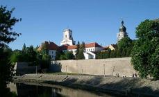
And this Decin Castle, built in the 13th century over the Labe River. This is the main attraction of the town. Since the 19th century, the castle has been the cultural center of the region. It was owned by representatives of the influential Thun family. Many famous writers, artists, and composers were received here, among them Walter Scott and Frederic Chopin, who wrote the Decin Waltz. Guests were impressed by the huge orchid garden. It was considered one of the largest in Europe. Now in the alleys of the castle you can see a beautiful rose garden - Decin Rose Garden.

We booked these apartments near Decin Castle - Czech Switzerland Castle Apartments.
Studio apartment in an old house on the 3rd floor, with a kitchen and free parking in the yard. An elevator takes you to the floor. The apartment we booked has a balcony. In the photo - on the right. There are light green chairs on it.

We were met by the owner, a pleasant, cheerful guy, David, who showed us the accommodation and told us about the most interesting sights of the city and the surrounding area. I really liked the apartment. Everything is clean and tidy, original interior.


On the ground floor there is a cozy cafe with sweets and drinks. Children are happily splashing in the fountain. Across the road - small lake. View from our balcony.

We view Decin Castle from the balcony of the apartment. I didn’t have the strength to visit it at all))) It’s a pity that we underestimated the tourist potential of Decin and stayed here for only one night. The city also has a zoo, a water park, ancient buildings, ancient bridges, 15 km away - the most big mountain Czech Switzerland - Decinsky Sneznik. In David's apartment there are many brochures describing the routes and attractions of Decin.

I only had enough strength to go to the supermarket to replenish food supplies for the next day and buy something for dinner and breakfast. But even on the way to the supermarket and back, we managed to walk around the lake.

On the opposite bank from the apartment we found the restaurant “Fabrika”, which David recommended.

But we have other plans for this family evening: Czech dumplings, cold German Radeberg beer and gorgeous view from the balcony. 
The next day we will travel to Budapest with a 3-4 hour stop in the capital of Slovakia, Bratislava.
How to get to Saxon Switzerland
The Saxon Switzerland National Park is located on the border of Germany and the Czech Republic on the German side and is a mountain forest of the Elbe sandstone mountains. The colors of the mountains are given by their bizarre shape, formed under the influence of the “blowing effect”, in addition, there are numerous historical monuments, including the most ancient and picturesque - the Bastei Bridge and the Königstein Fortress. The national park is very popular among all lovers of natural attractions and is one of the most visited parks in Germany.
The Saxon Switzerland National Park is located 125 km from Prague and 30 km from Dresden, so most tourists come to the park from these large cities. Group excursion tours to Saxon Switzerland are often organized from Prague or Dresden, but you can get to the park on your own. The infrastructure of the park itself is very developed, it is convenient for people with different abilities to move around here, and climbing the mountains along specially designed routes will not be tiring.
 Petr Meissner/Winterberg, Saxon Switzerland
 How to get to Saxon Switzerland from Prague
The most convenient way to get from Prague to Saxon Switzerland is by rented car. The travel time will take no more than 1 hour 20 minutes, and along the way you will be able to explore picturesque natural places. Prague and the park are connected highway No. E55. At Please note that to travel to the National Park you will have to cross the state border, so check with the rental office if this requires an additional permit for the rental car.
You can also get to the park from Prague by public transport. The closest settlements to Prague are the resort villages of Rathen and Bad Schandau. By the way, if you wish, you can stay here longer, since the resorts offer climate and mineral treatment. There are trains from Prague to the resort of Rathen Kurort and the town of Bad Schandau, direct trains to Bad Schandau (about 2 hours on the way), and a transfer to the resort of Rathen (about 3 hours on the way). You can check the train schedule and purchase tickets online on the website or O.B.B.. From the resort of Rathen you can start your journey on foot to Saxon Switzerland, while from Bad Schandau you will have to take a local bus.
In addition, you can take a ready-made bus excursion from Prague to the park. Bus and walking tours are in Russian and last a total of approximately 10 hours. Thanks to the excursion, you will be able to see all the most beautiful places in the natural park, including the observation deck of the Elbe River, without the need for transfers, as is the case with public transport. The excursion can be found on the spot or booked in advance through specialized services such as
and others similar.
How to get to Saxon Switzerland from Dresden
Getting to Saxon Switzerland from Dresden is even easier. There are direct trains between Dresden and the resort of Rathen or Bad Schandau, the journey time is only half an hour. Trains run every hour throughout the day. You can check the train schedule and purchase tickets online on the website . Next, from the Rathen resort station, you need to go to the pier and buy tickets for the local ferry across the Elbe (travel time is about 5 minutes).
Once on the other side of the Elbe, you will see right in front of you the picturesque Elbe Mountains, the hiking routes of which will lead you to their peak. In the park you should move around following the signs; they are located almost everywhere, and it is difficult to get lost here. In addition, there are quite a lot of tourists in the park at almost any time of the year (in winter, during snowfalls, the park may be closed).
 Thomas Queen/Panorama of the Elbe River
 Where to stay in Saxon Switzerland
The Saxon Switzerland National Park is quite extensive; there are many hiking routes here that will last more than one day. If you plan to stay here longer, then it would be most convenient to stay in one of the nearest settlements, so as not to return to Dresden or Prague. The closest towns to the park are the resorts of Rathen (closer, within walking distance) and Bad Schandau (further away, you need to get there by bus or train). Both resorts are quite intimate; they feature traditional half-timbered architecture and have all the infrastructure necessary for recreation.
For example, you can stay in the Rathen resort in hotels Elbiente 4* , Elbschlosschen 4* , Amselgrundschlossen 3*. The advantage of the hotels is their location - in the center of the resort, as well as the presence of restaurants and indoor swimming pools on site. You can stay in rooms of varying sizes. As a rule, Wi-Fi in resort hotels is provided free of charge, and there are no problems finding free parking if you are traveling by car.
In Bad Schandau you can find an even larger list of accommodations, since the town is considered a thermal resort. There are several thermal complexes here, specializing in the treatment and restoration of various diseases. Bad Schandau is a year-round resort and is in constant demand among tourists. You can stay in Bad Schandau in hotels Steiger Ban Schandau 4*, Parkhotel Bad Schandau 4*, Elbhotel Bad Schandau 3*and others. Full list Accommodation options in Bad Schandau can be found on the website Booking.com.
 Torsten Maue/Bad Schandau
 What to see in Saxon Switzerland
The Saxon Switzerland National Park is extremely rich in attractions. They are based on Elbe Sandstone Mountains, having a peculiar shape, which, in turn, was created by nature itself over many millennia through blowing and erosion. The landscape of the National Park is very diverse. Along specially laid routes you can see not only the mountain range, but also fairy forests, overgrown with boxwood, waterfalls, as well as some historical attractions, such as Königstein Fortress And ancient Bastei bridge, which are connected by the mountain peaks of the same name, the highest in the park.
 Allan Gray/Resort Rathen
 There are many hiking routes inside the park, designed for different levels of training and different times. The most popular route is the climb to Mount Bastei with an inspection of the bridge of the same name, as well as a route to Königstein fortress. Both places are extremely picturesque, as they are located on the edge of rocky cliffs. Both the bridge and the fortress offer panoramic views of the mountains, the Elbe River and the resort of Rathen.
In addition to Mount Bastei itself with an ancient bridge and the Königstein fortress, you can also see other attractions on the territory of Saxon Switzerland. In particular, these include valleys, waterfalls, forests, canyons and caves. If you want to move away from popular routes, then travelers also deserve attention Lichtenhain Falls, Stolpen fortress, rock gate Kushtal, and "artists' trail" with the most picturesque viewing platforms.
 superscheeli/Bad Schandau
 It is worth noting that entrance to the Saxon Switzerland National Park is free. Only ferry services across the Elbe and entry tickets to the Königstein fortress (8-10 euros depending on the time of year).
Overall, we can say that the Saxon Switzerland National Park is an excellent alternative for a day trip from Prague or Dresden. This is where you can “swap” city landscapes for natural ones and enjoy some of the most amazing views in Europe. In addition, there is every opportunity to stay in the scenery of nature for as long as possible - there are resorts Rathen and, which also offer many leisure opportunities.
Saxon Switzerland and Dresden are frequent tourist routes one day from Prague, both destinations are popular among travelers. About, , On a note :
When going on a trip to Europe, do not forget to take out a travel insurance policy, which is mandatory already at the registration stage tourist visa. You can take out insurance yourself without leaving your home. There are special services for this, such as , and others. You can purchase a policy online and then print it on a regular printer.
Photo at the beginning of the article: Bernd Thaller