At the beginning of the puzzle, the children look at the globe and find mountains. Show them and name them. The teacher reads A.S. Pushkin's poem "The Caucasus". Children tell how the poet saw the mountains. Then the teacher invites the children to visit an exhibition of photographs that depict mountains. Children look at photographs in which both waterfalls and mountain lakes, and forests. The teacher invites the children to assemble the picture-puzzle "Mountains". Then the children listen to Edvard Grieg's music "In the Cave of the Mountain King" and talk about their impressions and fantasies. The teacher shows the children a letter sent by the Mistress of the Copper Mountain. Children find the parcel and guess the contents of the parcel according to the riddle. There were different stones in the package. The teacher invites children to become geologists-researchers. Each child takes one stone, sits down at the table and examines the stone. The research results are recorded in a table. Then several children, based on the results of the research, talk about their stone. Dynamic pause - outdoor game - "Wind, rain, stone and mountain". To the music, the Mistress of the Copper Mountain comes to the children and brings various gems as a gift, which the children use in productive activities. Children decorate vases that they have made in advance with stones.
Download:
Preview:
LMDOU No. 6 "SUN"
SUMMARY OF LESSONS ON ECOLOGY
IN THE PREPARATORY GROUP
ON THE TOPIC OF:
“WHAT DID THE MOUNTAINS TELL ABOUT?”
COMPOSED BY THE EDUCER:
Shtatnova E.V.
2010
TARGET:
1. Continue to introduce children to inanimate nature, give basic information about mountains: what mountains are, who lives in the mountains, what grows, what mountains are made of;
2. Continue to acquaint children with the properties of stones (strong, hard, smooth, etc.);
3. To develop cognitive interest, the ability to analyze, compare, generalize, draw the simplest conclusions;
4. Learn to work with the table and write down the results of the survey;
5. Improve the ability to compose short story about stones, using the table;
6. Clarify children's knowledge about the use of stones (construction of buildings, bridges, roads);
6. Show children products made of precious stones;
7. Develop fine motor skills of hands;
8. Cultivate aesthetic feelings: teach to see the beauty of the mountains and learn to admire it;
9. Repeat the rules of behavior in nature.
VOCABULARY WORK:
1. Introduce children to a new word - geologist;
2. Activate the vocabulary of children through the words: rough, low, gentle, steep, snowy.
MATERIAL FOR THE LESSON:
1. Globe;
2. "Box of sensations";
3. Vessels with water;
4. Stones for each child;
5. Napkins;
6. Illustrations depicting mountains;
7. Split picture depicting a mountain;
8. Plasticine vases;
9. Jewelry box with precious stones;
10. Letter in an envelope from the Mistress of the Copper Mountain;
11. Riddles about stones and the globe;
12. Stone study tables;
13. Musical recording: Edvard Grieg "In the cave mountain king»;
14. Box with stones for crafts;
15. Hero - "Mistress of the Copper Mountain."
PRELIMINARY WORK:
Examination of stones in class and in free time;
Gathering a collection of stones;
Creation of an exhibition of stone crafts;
Reading Bazhov's tales "The Mistress of the Copper Mountain";
Excursion to the library;
Conversations on the topics: “What are the stones”, “What are mountains?”, “How a person uses stones”;
Watching a movie based on P. Bazhov's fairy tale "Stone Flower";
Conducting games: “Remember the fairy tale”, “What has disappeared?”, “Find your stone”;
Listening to the music of Grieg "Procession of the Dwarves", "In the cave of the mountain king".
STUDY PROCEDURE.
The teacher and the children enter the room.
The teacher makes a riddle:
Standing on one leg
Turns, turns his head
Shows us countries
Mountains, rivers, oceans.
What is this? (Globe).
Educator:
Right. Let's go up and look at the globe. Why is the globe colored different colors? (Brown are mountains, blue are seas, rivers, green are forests, fields, yellow are deserts).
That's right, well done. Who will show us the mountains on the globe? (The child points to the mountains on the globe).
And tell me, can the mountains tell us something about themselves? (Answers of children).
Today we will find out what the mountains can tell us. And poets and writers, photographers and composers will help us in this. Which of you will name the mountains? (Ural, Caucasus).
Educator:
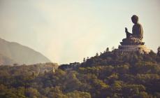
Well done, and there are the Himalayas, Altai, Alps. Guys, mountains have always attracted people. Poets composed poems, artists painted pictures, composers wrote music, writers composed fairy tales. Listen to A.S. Pushkin's poem, which is called "The Caucasus":
...Here the clouds humbly walk under me;
Through them, falling, waterfalls rustle;
Beneath them the cliffs are naked masses;
There, below, the moss is lean, the bush is dry ...
Educator:
Guys, how does the poet describe mountains? What did he see? (He sees clouds, waterfalls, cliffs, dry bushes and moss).
Educator:
Yes, guys, A.S. Pushkin saw the mountains like that and told us about them.
And now let's go to our photo exhibition.
Looking at photographs. The teacher comments on the examination.
What a beauty. See what mountains are? (Large and small, with snowy peaks, with waterfalls, covered with forests, spewing fire and stones).
Educator:
Did you like the photos? (Yes).
Guys, can you name the animals that live in the mountains? (Sheep, goats, eagle, hawk).
Well done, what grows in the mountains? (Moss, shrubs, trees).
And in the mountains there the purest lakes and rivers. Guys, I have a puzzle picture. Let's pick it up and see what we get. Now everyone will take a fragment of the picture, and we will try to collect it.
Children put together a puzzle picture.
Educator:
What did we get? (Mountains and lake).
Educator:
But the composers saw and depicted mountains in their own way. Sit on the carpet. Now you will hear the music written by the composer - Edvard Grieg. It's called "In the Hall of the Mountain King". Close your eyes and think about what you can imagine while listening to this music.
After listening, the children stand up and tell their thoughts.
Educator:
Well done, that's what you dreamers. And I have a surprise for you.
The teacher shows the children a letter and says:
You know, a letter was handed over to me today, but how can I find out to whom it is addressed?
Children:
You need to look at the address that is written on the envelope.
Educator:
Right. And who knows the address of our kindergarten?
(Answers of children).
The teacher reads the address on the envelope aloud:
City of Losino-Petrovsky, Stroiteley Street, 7, preparatory school group No. 5. That's right, the letter was written for us.
The teacher opens the letter and reads it aloud:
- “Hello, dear children. I know that you love to explore everything, so I am sending you a package. It is square, burgundy, with a lock, tied with a ribbon. I know that the package was delivered to you, you need to find it. Mistress of Copper Mountain". And who is the Mistress of the Copper Mountain? (She lives in the mountain, guards the mountains and protects them. She is from a fairy tale).
Educator:
Yes guys. The Mistress of the Copper Mountain gave us a task. Well, you need to look for the package.
Children find the parcel and give it to the teacher.
Children:
And here's another note.
Educator:
Yes guys. There's another note here.
- “You can open the parcel if you guess the riddle:
It burns with fire in mom's earrings.
In the dust on the road lies unnecessary.
He changes form, he changes color,
And in construction it is good for a thousand years.
Heavy, large - one cannot lift,
Or maybe easy - lie in the palm of your hand.
Who, children, guessed my riddle?
Who recognized this object by signs?
Children:
This is a stone, different stones.
Educator:
Let's see if you guessed the riddle correctly.
The teacher opens the box
Look, here are the stones. So we guessed the riddle correctly. Thanks to the Mistress of the Copper Mountain. Here is a gift. Guys, do you know where there are a lot of stones? (In the mountains).
Educator:
- Of course, most of the stones are in the mountains. After all, mountains are made of rocks.
Educator:
Guys, who is looking for stones and examining them? (Geologists).
That's right, now we will turn into geologists for a few minutes and explore the stones. Take a stone each and sit down at the tables. You have a table on your table in which we will record the results of the study of stones.
Stones are being examined and the results are recorded in a table.
Educator:
Well done, are you done? Who wants to talk about their stone?
The story of 2-3 children.
CONCLUSION:
What conclusion can we draw? What have we learned about stones? (There are big and small, smooth and rough, light and heavy, different colors, but they are all stones).
Educator:
Guys, do you know that scientists can learn a lot about mountains from stones: what mountains are made of, when there will be a volcanic eruption, when mountains were formed and what destroys them. Do you know what destroys mountains? (Rain, wind).
And we all know the game "Wind, rain, stones and mountains." Let's play. Be careful.
Attention game "Wind, rain, stone and mountain."
Educator:
You have all been very considerate. And your mountain turned out to be high and steep. We sit down.
Children sit at tables.
Educator:
Guys, we looked at the photos and listened to the music. And who will tell me which writer wrote fairy tales about mountains? (Bazhov)
- That's right, Pavel Bazhov. He wrote stories. What are tales? (Fairy tale and truth).
That's right, a tale is both a fairy tale and a true story. And what mountains did Bazhov write about? (About the Urals),
Right. Let's remember what Bazhov's tales do you know? (Stone Flower, Malachite Box, Silver Hoof, Mistress of the Copper Mountain).
Music sounds and the Mistress of the Copper Mountain enters. In her hands is a malachite box.
Hello guys. You recognized me? (Yes, Mistress of the Copper Mountain).
That's right, well done. I heard that you are talking about my treasures, and I could not sit in the mountain of stone. Did you solve my riddle? (Yes, they are stones).
Mistress of Copper Mountain:
Well done. Do you know where stones are used? (For the construction of roads and houses, for the manufacture of jewelry).
Right. I brought you my gems, look how beautiful they are. People learned how to process stones and began to make jewelry out of them.
The guest shows the children jewelry made of stones.
Mistress of Copper Mountain:
I have many different stones in the mountains. And I brought you beautiful pebbles with which you can decorate some kind of craft. Here they are.
The guest shows the children colored pebbles.
Educator:
Thank you, but we just need stones to decorate the vase that the children made yesterday.
The hostess of the Copper Mountain gives the teacher a tray on which there are sockets with pebbles. The teacher places sockets for the children on the tables.
Educator:
Guys, let's decorate our vases with these pebbles.
The kids get to work.
The guest watches the work of children.
Educator:
Guys, we're done.
The guest examines all the vases and praises the children:
What a beautiful job, well done. You made me happy. I would like to thank you for your knowledge and needlework. I have another gift for you, magical edible stones. Here he is. I will give them to Elena Viktorovna, and she will treat them to you in the group.
The guest gives the teacher a vase with sweets-pebbles.
And I have to go. Goodbye, see you again.
Says goodbye and leaves.
Educator:
Guys, did you like our trip to the mountains? (Yes).
What did the mountains tell us? (Mountains are different: high and low, steep and gentle, with snowy peaks and green forests, various animals and birds live in the mountains; there are rivers and lakes in the mountains; in the mountains there is very clean air and clean water).
Guys, today we talked a lot about mountains. And you know that the mountains do not forgive a person for inattention and carelessness. Can you tell me how to behave in the mountains? (Do not make noise, otherwise there may be a collapse and will be covered with stones; carefully look to see if there is a cliff and whether it is possible to walk along the path; if a fire is lit, then it must be put out; do not litter).
Well done. You learned a lot today and remembered what you knew. This knowledge will be useful to you in school.
The children leave the room.
A message on the topic “What are mountains” for children will briefly help you prepare for a geography lesson and deepen your knowledge of these major landforms.
Mountain message
You already know that the surface of the planet is not perfectly flat. It has hills, canyons, plains and mountains. These "roughnesses" are collectively referred to as terrain. And each area is characterized by its unique relief.
Mountains- This is a large elevation of the Earth's relief, which can be seen for kilometers. Even the smallest mountain will be visible from afar. By the way, over time, elevations can decrease, as the winds blowing over the mountain carry away the grains of sand that have broken off from it year after year.
The mountains are composed of:
- Peaks - the top of a mountain.
- Slope - that part of the mountain along which they descend from the top to the bottom.
- Foot - the lower part of the mountain. This is where the slope ends and the normal terrain begins.
The shape of the mountains can be very different. Some have sharp peaks, others flat tops or similar to oval domes.
The higher the mountain, the more severe and colder the climate on its top. And what is most interesting, there can be incredible heat at the foot, and at the same time the top of the mountain is covered with a huge cap of snow and ice. Then small streams begin to gather from the top and closer to the slope they turn into a real river. Yes, rivers also erode the surface of the elevation and reduce the height of the mountain.
When did mountains appear?
They appeared a very long time ago, millions of years ago, when there were terrible earthquakes on the planet. Fountains of red-hot lava strongly beat from the ground and froze, turning into mountains. These mountains still exist today. Under them, lava is still boiling, which at any moment can break out. This process is called a volcanic eruption, and such mountains are called an active or dormant volcano. But the mountains, under which lava does not show activity, are called an extinct volcano. It is worth noting that the frozen lava is a source of minerals, therefore, in the mountains, work is underway to extract metals, ore or precious stones.
You can rarely meet seamounts. Under water, it is impossible to notice, but sometimes the top of a similar mountain sticks out of the water and resembles a rocky island.
Interesting Mountain Facts for Kids:
- The highest mountain in the world stands on the border between Nepal and China. It's called Everest. The height of its peak is 8848 m.
- Some mountains are formed on the place where once there was a sea or ocean. This happened in the process of shifting the folds of the seabed. These mountains include the Carpathian Mountains, the Himalayas and the Alps. In them you can find the remains of marine organisms.
- The African mountain Kilimanjaro was formed due to the eruption of lava from underground.
- The process of aging, reduction or growth of mountains is imperceptible to the human eye. After all, these processes take millions of years.
- In ancient times, mountains were considered the home of the gods. Therefore, to sacred mountains even approaching was strictly forbidden.
- The highest peaks in the world are Everest, Mont Blanc and Elbrus.
We hope that grade 4 was able to use the message about the mountains in preparation for the lesson. A short story about the mountains you can leave through the comment form below.
To go to the mountains, it is not necessary to be a climber, even in remote mountains there will always be a path that will be accessible to a person of any age and with any level of training. In order for a hill to be considered a mountain, it must have a height of more than 500 meters, there are many such places - the mountainous form of relief occupies about 40 percent of the land area. Introducing Interesting Facts about mountains.
Bastei Bridge in Saxon Switzerland
Records
The highest mountain in the solar system is on Mars. The top of Olympus has a height from the foot of more than 21 kilometers, if you count from the conditional "level of the Martian sea", then the height of this mountain is 26 kilometers. The highest mountain from top to bottom is Reyasilvia, located on the asteroid Vesta.
The most high peak on the ground - Chomolungma, 8848 meters. If you count not from sea level, but from the bottom to the top, then the very high mountain is the Hawaiian volcano Mauna Kea, above sea level it rises to 4205 meters, but part of the mountain is hidden under water, the height from the base is 10203 meters.
On the mountain ranges there are about a hundred peaks over 7000 meters high. There are two peaks in the world that climbers have not yet conquered - Ganghar Puensum (Bhutan), 7570 meters and Saser Kangri II (India), 7518 meters.
In the Himalayas, 30 peaks are higher than 7500 meters, 14 peaks are higher than 8000 meters.

Ama Dablam summit in Nepal
Mount Monadnock in the United States has a low height - 965 meters, but is known for being the most climbed by climbers.
The highest camp site, which looks like a village, is located at the foot of Everest, at an altitude of 6330 meters. Despite the fact that all the buildings are tents, there is a hospital, a kitchen, and sleeping places. Smaller camps are set up at an altitude of 5900, 6400, 7300, 7950 meters. In them, climbers stop for a while so that the body gets used to the height.
The Sherpa people of the Himalayas are accustomed to heights. They help tourists to climb. One of the Sherpas reached the summit of Everest in 8 hours and 56 minutes.
The most famous climber is Reinhold Messner. He conquered 14 peaks higher than 8 kilometers. In 1978, he and Peter Habeler climbed Everest for the first time without oxygen tanks. In 1980, he climbed Everest solo for the first time. In 1980 he conquered three eight-thousanders in one year.
Everest was first climbed in 1953 by New Zealander Edmund Hillary and his Sherpa guide Tenzing Norgay.
The highest mountain in Africa is Mount Kilimanjaro (5895 meters). Despite the fact that the mountain is located in a hot area, its top is always covered with snow.
The Alps cover two-thirds of the area of Switzerland.
The highest waterfall is Angel Falls (Venezuelan state of Bolivar), its height is 979 meters, the height of a continuous fall is 807 meters.
Highest active volcano- Chilean mountain Ojos del Salado, its height is almost 7 kilometers.
Alpine settlements
Fun facts about highland cities. La Paz is the highest mountain capital in the world average height- 3600 meters (buildings are located at an altitude of 3 to 4 kilometers). In fact, the capital of Bolivia is not La Paz, but Sucre, but La Paz hosts most of the government institutions. El Alto Airport is located at an altitude of 4061 meters, it ranks second in the world in height (the highest airport is in China, the height is 4411 meters). Water in La Paz boils at 88 degrees Celsius. The local stadium is the highest certified by the international football federation, for other stadiums there is a rule that they should not be located at a height higher than 2.5 kilometers if they want to organize international matches. Interestingly, the central bus station this city was designed by Gustav Eiffel, architect eiffel tower in Paris.

If we assume that La Paz is not the capital, then the highest mountain capital in the world is Lhasa (Tibet), with an altitude of 3650 meters. Lhasa is the capital of the Chinese Autonomous Region, until 1951 the city was the capital independent state Tibet.
Peru has the highest city in the world - La Riconada, the central part is located at an altitude of 5100 meters. The population is quite significant, about 30 thousand inhabitants.
The highest city in the world with a population of over 50,000 is Cerro de Pasco, Peru. central part located at an altitude of 4380 meters, the population is about 70 thousand people.
The highest mountainous metropolis is El Alto, with a population of over 1 million people. The height of the central part is 4100 meters.
The highest mountain city on the territory of the former USSR is Murgab, Tajikistan, the population is 6300 people, the height of the central part is 3612 meters.
The Dagestan settlement of Kurush is located at an altitude of 2600 meters. It is considered the highest in the Caucasus and Europe, the population is 830 people.
Danger
The weather can be deceiving - it can be hot during the day, but the temperature can drop dramatically at night. You need to be careful, because hypothermia, which can lead to serious consequences for health and even death, can be obtained already at a temperature of 10 degrees Celsius. And such a temperature can be in the usual summer season, so you should always take warm clothes with you to the mountains and take care of the opportunity to make a fire and cook warm food in advance.
It is easy to get frostbite in the mountains in winter. Contrary to popular belief, alcoholic beverages do not warm, but contribute to rapid hypothermia, and if it is very cold outside, then frostbite of the limbs. Alcohol dilates blood vessels, and heat comes out of the body faster. So in the cold it is better not to drink alcohol, but to warm up with quick movements. In addition, alcoholic drinks dull vigilance, under their influence a person can even fall asleep, which is very dangerous in the mountains, where frost can come suddenly even in summer.

Avalanches are a big danger. In order to get off dangerous wave snow, it is not necessary that the slope be steep, under certain conditions, when a layer of melted water forms between the snow and the ground, an avalanche can descend on a slope of only 8 degrees. So a gently sloping mountain may seem completely harmless in appearance, but in fact pose a mortal danger. It is very difficult for a person stuck in an avalanche to get out, as the snow compacted by the action of the avalanche has almost the same density as concrete, so you need to be very careful and try not to climb snowy slopes. Sports climbing must have the most reliable insurance and third-party observers who can help in case of problems.
Now a popular sport is wingsuit flying, when an athlete glides in a special suit with small wings, these clothes are called a wingsuit. Despite the spectacle of this sport, it is very dangerous, according to statistics, about 2 jumps out of 1000 end in death, as athletes jump from rocks, most deaths happen due to hitting a rock (about a third of tragic cases). When jumping from an airplane, the mortality rate is lower, but also significant - up to 30 tragic cases per 100,000 jumps.

Climbing is also dangerous, especially when it comes to the Himalayan peaks. most dangerous mountain considered Annapurna, every fourth climber dies during the ascent. The highest mountain in the world, Chomolungma (Everest), has similar statistics. Since it is very difficult and dangerous to lower the bodies of the dead from this mountain, the dead remain on the slopes, this is an eerie reminder that one should not take too many risks, even for the sake of significant sporting achievements. It is not possible to refer to the inexperience of the athletes here, since the most experienced climbers climb the eight-thousanders, the strongest and most courageous people, but probably the most reckless, because if you manage to descend safely, very often with frostbite, which can end in amputation of limbs . Climbing is a great sport, but you need to be extremely careful when climbing difficult peaks.
In Russian ski resort Dombay in 2013, a large zorb ball, in which there were two people, rolled into a deep mountain gorge. There were two people in the balloon - one tourist received a compression fracture of the spine and died on the way to the hospital, the other received a concussion. The cause of the tragedy was non-compliance with safety rules - below long route the ball was caught by one person, there were no barriers from the side of the cliff. After the attraction employee did not catch the ball, he rolled (in fact, flew) for another one and a half kilometers down the rocky slope and ended up in a place so inaccessible that it was difficult even for trained rescuers to get to him.

There are many "mountain" sports - mountaineering, rock climbing, ice climbing, hiking, skiing. skiing, snowboarding, sledding, mountain biking, boarding on volcanic ash, zorbing (descent on a ball from a mountain), hang-gliding, paragliding, kite flying (often combined with skiing), wingsuit, bungee jumping, speleology, rafting ( rafting and other watercraft), canyoning (passage of canyons without equipment). All mountain sports are dangerous, but this does not mean that they should not be practiced. It is necessary to observe safety precautions, be careful, do not drink alcohol, then entertainment associated with an increased content of adrenaline in the blood may not become completely safe, but at least it will be safer. Remember, excessive risk is always unacceptable, do not do anything that could threaten health and life.
Mountaineering is a rewarding activity. An example of "folk mountaineering" can be South Korea. IN South Korea The most common entertainment among people of any age is hiking in the mountains. There is nothing surprising if after the holiday people do not sleep off, but gather, and the company goes to the mountains. Perhaps this tradition exists due to the fact that holidays in this country are very small and can be only a few days a year. public holidays also few - about 10 days a year, and if they fall on Sunday, then they are not transferred to Monday. People use every possible minute to relax in nature. And the mountains in South Korea are almost everywhere - this is a country with a complex, but very picturesque relief.
Victoria Popova
Abstract of the complex lesson "What the mountains tell about"
Subject: About what mountains tell.
Educational - continue to introduce children to inanimate nature, give basic information about mountains: what are mountains who lives in the mountains, what grows, what they are made of mountains; Introduce the words - magma, vent, lava.
Educational
To develop cognitive interest, the ability to analyze, compare, generalize, draw simple conclusions.
Develop children's cognitive activity in the process self-fulfillment experience.
nurturing: Encourage children to draw conclusions on their own.
- Guess the riddle: Stands on one leg, turns, turns his head, shows us countries, mountains, rivers, oceans.
What is this? (It's a globe)
-Consider a globe. Why is the globe painted in different colors (brown mountains, green - plains and forests, blue - seas, yellow - deserts)
show on the globe mountains. A video message is played in which the mistress of the mountains invites the children to discover the secrets she has hidden in envelopes.
What do you think mountains can tell about themselves?
The children come to the table on which the envelope lies, the teacher takes out the task from it.
In front of us on the table are stones of various shapes and sizes. arrange them so that the old stones are in one basket. And the young in the other. (Children examining the stones, distributed in baskets)
Explain your choice. (children explain: pointed stones are young, and smooth are old. They became so from time to time thanks to the wind and water)
Guys, can we figure out what mountains old, and which young (children consider photo depicting mountains, explaining where the old mountains where the young
Now we move on to the next envelope.
Look at this diagram. What do we see? Mountains these are giant folds of the earth's crust, that is, skin. They consist of layers of various rocks. Some rocks are hard while others are soft. Soft rocks are easily affected by rain and wind. Because of this, collapses occur in the mountains, gorges, cliffs, canyons are formed.
-Solid: granite, coal, diamonds, silicon, malachite.
-Soft: chalk, gypsum, asbestos.
Minerals are mined in different ways. Some in open pits, others deep underground in mines.
Guys, is it possible to find shells in the mountains? It turns out you can. Mountains were once coral reefs, but are now far from the sea. Since that time, shells have been preserved in the rocks. The highest mountain in the world, Everest, is located in Himalayan mountains. What mountains of Russia do you know the names of? (Caucasian mountains, Ural).
Here is another secret about minerals discovered.
Let's move on to the next envelope.
Look carefully at these pictures. (they depict animals and birds, trees and shrubs located in the mountains) Please tell me how these pictures are connected with the mountains? (Children express their opinions.) The answer is obvious - in the mountains there are not only stones, but also vegetation, animals and birds.
I see you are a little tired. I suggest doing a workout.
Children perform characteristic movements.
And now the next envelope is on our way. We open.
Look here for items that were used by blacksmiths in antiquity. I I will tell you about the fire-breathing mountains. These mountains called volcanoes. And they called them volcanoes because they existed legend: (children sit down on the carpet) There lived in the world a god named VOLCANO and he was a blacksmith. He built himself a blacksmith inside the highest mountains. He beat with a heavy hammer on iron, fanned the fire. And the mountain stood in the middle of the sea. When Vulkan worked with a hammer, the mountain trembled, the roar and rumble spread far around. From the hole at the top mountains red-hot stones, fire and ashes flew with a deafening roar. The volcano is working, people said with fear and went away from this place. Since then, they began to call fire-breathing mountains"volcanoes".
Now there are three types on earth volcanoes: Sleepers - who can wake up to explode in fiery lava at any time.
Active - constantly spewing fountains of boiling lava.
Extinct - those that erupted a very long time ago, but are now extinct.
Let's go to the table. It has a model of a volcano. Volcanoes as we see it cone-shaped mountains. If you look from above, you can see a hole - this is a crater, a large bowl with steep slopes, and at the bottom is bright orange - this is a vent-hole that goes deep into the ground. And the fiery liquid coming out of the volcano is lava.
So the historical secret of the mountains was revealed to us.
The next secret is the envelope.
The mistress of the mountains offers us to make a volcano on our own.
Inside the layout is a plastic yogurt cup. 1 teaspoon of soda, a little gouache paint, citric acid, 3 drops of detergent. Consistently mixed and observed. (There will be a simulated volcanic eruption)
But at the bottom of the ocean, when an eruption occurs, the frozen lava can form a cone of such a height that if the top is above the water, then after the volcano goes out there will be an island. Many islands in the Pacific Ocean are of volcanic origin.
It's good that everyone got a volcano. Did you like the secret mountains?
A video clip is turned on in which the hostess of the mountains says that everyone coped with the tasks. Now they are rewarded for their work. Only in exchange we must remember the secrets that she revealed to us.
I thank you all for today's work.
Our planet Earth was once a hot ball that gave off its heat to interplanetary space and gradually cooled. The composition of the Earth included various chemical elements, and as it cooled, the heavier ones sank down. Lighter elements floated to the surface, they first of all underwent cooling, solidified faster. As a result of this process, three main shells of the Earth were formed: a frozen shell of granites and basalts; the ore shell of light metals and, finally, the core of the Earth, formed by heavy metals. The Earth's crust did not form immediately. During solidification, violent processes took place, whole seas of molten mass broke through the solidifying crust. This mass subsequently also solidified, the resulting depressions were filled with water, and continents and oceans arose.
The earth continued to cool. Its inner part decreased in volume, and the outer stone shell fell and wrinkled under the action of gravity. On earth's surface large wrinkles formed. These folds, sometimes reaching enormous heights, are mountain ranges folded origin. During this formation of folds, the earth's crust cracked, and in some places molten masses again erupted. Huge cones of ejected materials piled up in such places, mountains of volcanic origin formed.
Mountain-building processes did not occur everywhere and not always with the same intensity and at the same time. Mountains have their age. The youngest mountain ranges are the Alps, the Caucasus and the Himalayas. The Urals arose earlier than these mountains, and the Donetsk ridge is even more ancient.
And today the earth's crust is not at rest. Some parts of it slowly rise, others fall.
Along with mountain building processes, processes of destruction of mountains have taken place and are taking place. Destructive factors are: wind, temperature changes and water.
The study of the outer shell of the Earth has shown that its constituent rocks can be divided into three main groups: sedimentary rocks, igneous rocks, metamorphic (altered) rocks.
The products of destruction of rocks dumped into the sea and the remains of organisms of marine animals have been deposited on the bottom of the oceans and seas for many thousands of years, forming thick layers of sediments. Due to the movement of the earth's crust, these layers rise from the depths of the sea, sediments are compacted, and sedimentary rocks are formed. The main characteristic of sedimentary rocks is their layering and homogeneity; all sedimentary rocks are relatively weakly durable. Examples of such sedimentary rocks are sandstones, limestones, pebbles and clays.
Igneous rocks were formed during the solidification of the molten mass. These are very strong, monolithic rocks, in which there are no signs of layering. These include granites, porphyries and basalts.
Metamorphic or altered rocks are formed when sedimentary rocks change under the influence of high pressure and high temperature. From this group it is possible to name: shales (modified clays), marbles (modified limestones). They still show signs of layering. Their strength is less than the strength of igneous rocks. Many of these rocks are very easy to delaminate.
The processes of mountain building and destruction create the relief of mountains. In any mountain range or in a separate mountain we distinguish: foot, slope, ridge and top. Sometimes several ridges converge at the top. The part of the ridge enclosed between two peaks is called the saddle; if a path goes through a saddle, or even passes a path from one slope to another, such a saddle is called a pass.
Ridges are very often used as a way to climb to the top, since they are the safest from avalanches and rockfalls. The steep slope of a mountain is called a wall. Separate rock towers blocking the path along the ridge are called gendarmes.
On the slopes of the mountains, there can be various depths of excavations and troughs. Wide recesses are called couloirs and are often filled with snow or small glaciers. Narrow corridors are called chutes. A wide vertical crack in a rocky or icy slope is called a fireplace. A narrow sloping or vertical crack is called a fissure. Entire “rivers” sometimes flow from the slopes of mountains and from wide couloirs from large and small fragments of rocks that break off from the slopes of the mountains; these stone rivers are called scree.
Mountain ranges are separated from each other by gorges or valleys. If there were glaciers in these valleys, the bottom of the valleys is relatively flat, the valleys are filled with moraines - high ridges of large and small fragments cemented with sand or clay.
Map
A map is a distorted image on paper of the entire earth's surface or part of it. The distortion occurs due to the fact that a spherical convex surface, the model of which is the surface of the Earth, cannot be deployed on a plane without breaking, as, for example, the surface of a ball cannot be stretched on a plane without tearing it. The exception is when the map shows a very small part of the earth's surface, which we can consider almost flat.
Maps differ in their content and scale. The content of the map can be: economic, physical, topographic, marine and special. The map scale is a ratio that indicates how many units of length on the earth's surface correspond to a unit of length on the map. For example, a scale of 1:100,000 indicates that 1 cm of the map corresponds to 1 km on the earth's surface. According to the accepted scales, maps (1: 500,000, 1: 250,000, 1: 100,000, 1: 50,000) and plans (1: 25,000, 1: 20,000, 1: 15,000 and 1: 10,000) are distinguished.
A topographic map also gives us an idea of the terrain, which is conventionally represented by hillshade or contour lines. In the first case, places with different heights are painted in different shades of green and brown. More convenient way are horizontals that make it possible to accurately determine the angle of inclination of the earth's surface. Contours are the projection onto a plane of lines connecting points that have the same height above sea level.
In order to distinguish a depression from a peak on a map, conditional dashes are used - berghstrih, which indicate the direction of the slope. Each horizontal is assigned its relative or absolute mark (height above sea level). This makes it possible to understand the relief even without berghstries. Knowing the distance between two horizontals and the excess of one of them over the other, it is possible to graphically determine the angle of inclination of the surface.
Using the map, we can judge the terrain, we can determine our location and choose the right path. To do this, you need to orient the map to the cardinal points and determine the direction to the peaks of interest to us or another goal of the path. Orientation to the cardinal points is made with the help of a compass. As you know, the magnetic needle is located approximately in the plane of the meridian, pointing one end to the north, the other to the south. When the arrow stops, you need to rotate the map so that the northern part of the map coincides with the northern end of the magnetic needle. (Typically, on a map, north is up, south is down, east is to the right, and west is to the left.) Any direction on a map or on the earth's surface is determined by an azimuth. This is the name of the angle between any direction and the northern end of the meridian; this angle is counted clockwise, varying from 0 to 360 °.
On the map, the azimuth is determined by counting the angle from the applied grid of coordinates, and on the ground by the compass. How can you now determine your location on the map? To do this, you need to see at least two peaks known to you, which are also plotted on the map. By determining the direction to these peaks, you can calculate the azimuths from these peaks to you. By plotting these azimuths with a pencil on the map, you will find your place at the intersection of the two drawn directions. If you need to put some vertex on the map, for this you need to solve the problem, the reverse of the one outlined above. To do this, you need to observe the peak from two points, postponing the azimuths determined from the two points from the corresponding peaks on the map, at the intersection point you will get the desired peak. In the same way, you can determine the distance to a point that is inaccessible for any reason. Knowing how to solve the two tasks described, it is easy to draw up a rough sketch (crooks) of the area.
A climber needs to be able to use a compass and a map in fog. Often he has to go in such conditions when the goal of the path is closed and he has to navigate by compass. We have already said above that one point does not determine the direction in space, therefore, when moving in fog, a group of climbers should line up along a given course and pass the compass to the latter. The last one, observing the entire chain by compass, will ensure progress in a given direction. The compass should be used in the same way at night.
Brief information on meteorology
Due to the fact that the axis of rotation of the Earth is not perpendicular to the plane of rotation of the Earth around the Sun, the average height of the Sun above the horizon is not the same for different points the globe. For example, in the polar regions, the Sun makes its visible path relatively low above the horizon compared to regions near the equator. The amount of heat coming from the Sun, the greater, the higher the Sun is. Therefore, the polar regions receive less heat per year than the equatorial regions. The sun's rays, penetrating through the atmosphere, almost do not heat it, but strongly heat the surface of the Earth. As a result, the heating of the atmosphere comes from below. As shown by numerous observations, the temperature decreases with height by about 5-6 ° per 1 km. At a certain height above sea level, conditions are created that the heat that comes during the summer is not enough to melt the snow that has fallen during the winter. As a result of this, snow masses accumulate, forming a strip of eternal snow. The height at which the heat balance is zero is called the snow line. The closer the mountainous region is to the pole, the lower the snow line lies.
The climate in any locality is determined by the totality of the weather during the year; in turn, the weather is determined by a combination of such meteorological elements as cloudiness, wind, rain, snow, hail, snowstorm, thunderstorm.
Air masses of different temperature and humidity move above the earth's surface. At the junctions of these masses, all meteorological elements are especially strongly developed. This division of air masses is called a meteorological front. A front always brings with it a change in the weather.
In order to roughly say what weather should be expected in the coming days, it must be borne in mind that any intensive movement in the atmosphere indicates the instability of a given mass of air, which, therefore, must wait for a change in these masses, the arrival of a front, and with it, changes weather.
When determining the nature of the phenomena that occur, it is very important to establish whether these phenomena are local, indicating the stability of the weather, or whether they are of a general nature and are associated with the general movement of air masses. In essence, all signs of the weather are indicators of local or general processes.
If there is a mountain breeze in mountainous areas, in the morning and in the evening a light wind blows from the mountains to the valleys, and in the afternoon it blows from the valleys to the mountains, this is a sign of stable weather. Steady weather is also indicated by the appearance of fog in the evenings in the valleys and dew. In a stable air mass with a clear sky, the atmosphere cools from below due to night radiation from the earth's surface, and the temperature begins to rise with height in some cases. You can notice this sign and thereby determine stable weather by climbing the slopes and directly observing changes in temperature. The same temperature distribution is indicated by the appearance of haze in the evenings in the gorges, as well as cumulus clouds floating at the same height during the day with slightly smoothed tops.
Any advance of the front indicates a change and worsening of the weather. A gradual decrease in atmospheric pressure is a sign of an approaching front, bringing with it clouds, precipitation and increased wind. The approach of high clouds is also a sign of approaching bad weather. At night, the approach of the front can be determined by the crown around the moon. In the mountains, the approach of bad weather is often determined by the appearance of standing clouds over the peaks.
Any strong movement in the high layers of the atmosphere indicates the instability of the air mass. These winds in the high layers can be identified by the appearance of cumulus clouds (lambs), and at night - by the increased twinkling of stars. Powerful cumulus pillar clouds with blurry tops, as a rule, portend a thunderstorm.
Glaciers
We have already said that above the snow line there is a continuous accumulation of snow. At the same time, the peaks are unloaded from snow and ice. This unloading is produced by falling avalanches and glacial runoff.
Avalanches and snow falls from ridges and peaks usually accumulate in cirques and depressions surrounded by a series of ridges. These cirques are the origins of glaciers. The snow accumulating in cirques gradually turns under the influence of meteorological factors and under the influence of its own gravity into fir-granular dense snow. Further compaction leads to the formation of firn ice, which consists of individual crystals. Separate crystals are soldered together, forming a continuous glacial ice, already devoid of signs of crystals. Under the pressure of snow masses, ice flows into the gorges, forming a glacial river. The speed of the glacier movement depends on the amount of snow and ice in the circus and ranges from 25 mm to 1.25 m per hour. Going down the gorge, the glacier destroys the rocks, smoothes the bottom of the gorge, carries with it stones falling on it from the ridges and from the surrounding peaks. The glacier carries all the destruction products down and, having reached the melting zone, deposits them in the form of lateral and terminal moraines.
Irregularities in the bed along which the glacier moves cause the glacial mass to crack. In those places where the glacial mass flows through the ridges running across the bed, cracks are formed, expanding upward, and above the depressions expanding downward. These cracks are located across the flow of the glacier and are called transverse. If the glacier flows into a wider part of its bed, longitudinal cracks form in these places due to the spreading of the ice mass. The different speed of ice movement in the middle of the current and near the banks of the moraines is the cause of the appearance of edge cracks directed at an angle to the banks. In the mountains, the climber has to overcome two more types of cracks: bergschrunds and weltklufts. The Bergschrund is a large fissure separating the actual flowing glacier from its cirque. Rantklufts are formed near the shores of the glacier due to different heating of the coastal rocks and the ice itself by the sun's rays. In those places where the slope of the glacier is especially steep, the ice masses, bursting, pile up in blocks and form ice falls.
The upper part of the glacier, above the snow line, is usually covered with snow. Snow sweeps up cracks, forming snow bridges under them. Below the snow line, the glacier becomes bare, and numerous streams flow along it. These streams then gather into one stream and, flowing out of a grotto, usually located at the tongue (end) of the glacier, form a mountain river. Glaciers are divided into three main groups: valley, hanging and transitional, having a gap in their course.