The Caspian Sea is one of the largest salt water bodies of the Earth, located at the junction of Europe and Asia. Its total area is about 370 thousand square meters. km. The reservoir receives more than 100 water flows. The largest rivers flowing into - Volga, Ural, Emba, Terek, Sulak, Samur, Kura, Atrek, Sefidrud.
The Volga River - the pearl of Russia
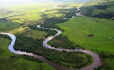
The Volga is a river flowing on the territory of the Russian Federation, partially crossing Kazakhstan. Belongs to the largest and long rivers on the ground. The total length of the Volga is more than 3500 km. The river originates in the village of Volgoverkhovye, Tver Region, located on Russian Federation.
It flows into the Caspian Sea, but does not have a direct outlet to the World Ocean, so it is classified as an internal drain. The watercourse receives about 200 tributaries and has more than 150 thousand drains. Today, reservoirs have been built on the river, allowing to regulate the flow, due to which the fluctuations in the water level have been sharply reduced.
The fishery of the river is diverse. Melon growing prevails in the Volga region: the fields are occupied by grain and industrial crops; salt is mined. Oil and gas fields have been discovered in the Ural region. Volga is the most major river, which flows into the Caspian Sea, so it is of great importance for Russia. The main transport facility that allows crossing this stream is the longest one in Russia.
Ural - a river in Eastern Europe
The Ural, like the Volga River, flows on the territory of two states - Kazakhstan and the Russian Federation. Historical name - Yaik. It originates in Bashkortostan at the top of the Uraltau ridge. The Ural River flows into the Caspian Sea. Its basin is the sixth largest in the Russian Federation, and the area is more than 230 square meters. km. Interesting fact: the Ural River, contrary to popular belief, belongs to the inland European river, and only its upper course in Russia belongs to Asia.
The mouth of the stream gradually becomes shallower. At this point, the river splits into several branches. This feature is typical throughout the entire length of the channel. During floods, you can watch the Ural overflow its banks, in principle, like many other Russian rivers flowing into the Caspian Sea. This is especially observed in places with a gently sloping coastline. Flooding occurs at a distance of up to 7 meters from the riverbed.

Emba - the river of Kazakhstan
Emba is a river flowing on the territory of the Republic of Kazakhstan. The name comes from the Turkmen language, literally translated as "the valley of food." The river basin with an area of 40 thousand square meters. km. The river begins its journey in the mountains of Mugodzhary and, flowing along, is lost among the swamps. Asking which rivers flow into the Caspian Sea, we can say that in full-flowing years, the Emba reaches its basin.
For coastline rivers are used to extract natural resources such as oil and gas. The issue of passing the border between Europe and Asia along the Emba watercourse, as in the case of the river. Ural, an open topic today. The reason for this is natural factor: mountains Ural Range, which are the main reference point for drawing boundaries, disappear, forming a homogeneous area.
Terek - mountain water stream
Terek - river North Caucasus. The name literally translates from Turkic as "poplar". The Terek flows out of the glacier of Mount Zilga-Khokh, located in the Trusovsky Gorge of the Caucasus Range. passes through the lands of many states: North Ossetia, Georgia, Stavropol Territory, Kabardino-Balkaria, Dagestan and the Chechen Republic. It flows into the Caspian Sea and the Arkhangelsk Bay. The length of the river is just over 600 km, the basin area is about 43 thousand square meters. km. An interesting fact is that every 60-70 years the flow forms a new transit arm, while the old one loses its strength and disappears.
The Terek, like other rivers flowing into the Caspian Sea, is widely used to satisfy human economic needs: it is used to irrigate the arid territories of the adjacent lowlands. There are also several hydroelectric power plants on the water stream, the total average annual output of which is more than 200 million kWh. In the near future, it is planned to launch additional additional stations.

Sulak - water stream of Dagestan
Sulak is a river that connects the streams of the Avar Koisu and the Andi Koisu. It flows through the territory of Dagestan. It starts in the Main Sulak Canyon and ends its journey in the waters of the Caspian Sea. The main purpose of the river is the water supply of two cities of Dagestan - Makhachkala and Kaspiysk. Also, several hydroelectric power stations are already located on the river, it is planned to launch new ones to increase the generated capacity.
Samur - the pearl of South Dagestan
Samur is the second largest river in Dagestan. Literally, the name from the Indo-Aryan is translated as "an abundance of water." It originates at the foot of Mount Guton; It flows into the waters of the Caspian Sea in two branches - Samur and Small Samur. total length rivers a little over 200 km.
All rivers flowing into the Caspian Sea are of great importance for the territories through which they flow. Samur is no exception. The main direction of using the river is irrigation of lands and providing residents of nearby cities with drinking water. It was because of this that a hydroelectric complex and a number of the Samur-Divichinsky canal were built.
At the beginning of the 20th century (2010), Russia and Azerbaijan signed an interstate agreement requiring both sides to rationally use the resources of the Samur River. The same agreement introduced territorial changes between these countries. The border between the two states has been moved to the middle of the hydroelectric complex.

Kura - the largest river of Transcaucasia
Asking the question which rivers flow into the Caspian Sea, I want to describe the flow of the Kuru. It flows on the land of three states at once: Turkey, Georgia, Azerbaijan. The length of the stream is more than 1000 km, the total area of the basin is about 200 thousand square meters. km. Part of the basin is located on the territory of Armenia and Iran. The source of the river is located in the Turkish province of Kars, flows into the waters of the Caspian Sea. The path of the river is thorny, laid among hollows and gorges, for which it got its name, which in Megrelian means “nibble”, that is, the Kura is a river that “gnaws” itself even among the mountains.
There are many cities on it, such as Borjomi, Tbilisi, Mtskheta and others. It plays an important role in meeting the economic needs of the inhabitants of these cities: hydroelectric power stations are located, and the Mingachevir reservoir created on the river is one of the main reserves fresh water for Azerbaijan. Unfortunately, the ecological state of the stream leaves much to be desired: the level of harmful substances exceeds the permissible limits by several times.

Features of the Atrek River
Atrek is a river located on the territory of Iran and Turkmenistan. It originates in the Turkmen-Kharasan mountains. Due to the active use in economic needs for irrigation of land, the river became shallow. For this reason, it reaches the Caspian Sea only during the flood period.
Sefidrud - the abundant river of the Caspian
Sefidrud is a major river of the Iranian state. It was originally formed by the confluence of two water streams - Kyzyluzen and Shakhrud. Now it flows out of the Shabanau reservoir and flows into the depths of the Caspian Sea. The total length of the river is over 700 km. The creation of a reservoir has become a necessity. It made it possible to minimize the risks of flooding, thereby securing the cities located in the river delta. Water is used to irrigate land with total area more than 200 thousand hectares of land.

As can be seen from the presented material, the Earth's water resources are in an unsatisfactory state. The rivers flowing into the Caspian Sea are actively used by man to meet his needs. And this has a detrimental effect on their condition: watercourses are depleted and polluted. That is why scientists around the world are sounding the alarm and conducting active propaganda, calling for saving and conserving water on Earth.
On Sunday, August 12, in Kazakhstan's Aktau, the presidents of Azerbaijan, Iran, Kazakhstan, Russia and Turkmenistan signed the Convention on the Legal Status of the Caspian Sea. Previously, its status was regulated by the Soviet-Iranian treaties, in which the Caspian Sea was defined as a closed (inland) sea, and each Caspian state had sovereign rights to a 10-mile zone and equal rights to the rest of the sea.
Now, according to the new convention, each country has its own territorial waters (zones 15 miles wide). In addition, the provisions of the UN Convention on the Law of the Sea of 1982 will not apply to the Caspian Sea, the seabed will be delimited into sectors, as is done by neighbors on the seas, and sovereignty over the water column will be established on the basis of the principle that this is a lake.
Why is the Caspian considered neither a lake nor a sea?
To be considered a sea, the Caspian must have access to the ocean, this is one of the most important conditions for a body of water to be called a sea. But the Caspian has no access to the ocean, so it is considered a closed body of water, not connected to the oceans.
The second feature that distinguishes sea water from lake water is their high salinity. The water in the Caspian Sea is indeed salty, but in terms of its salt composition it occupies an intermediate position between a river and an ocean. In addition, in the Caspian, salinity increases towards the south. The Volga delta contains from 0.3‰ salts, and in the eastern regions of the South and Middle Caspian, the salinity reaches 13-14‰. And if we talk about the salinity of the World Ocean, then it averages 34.7 ‰.
Due to the specific geographical and hydrological characteristics, the reservoir received a special legal status. The summit participants decided that the Caspian Sea is an inland water body that has no direct connection with the World Ocean, and therefore cannot be considered a sea, and at the same time, due to its size, water composition and bottom features, it cannot be considered a lake.
What has been achieved since the signing of the Convention?
The new treaty expands the possibilities for cooperation between countries, and also involves limiting any military presence of third countries. According to political scientist, director of the Institute of Recent States Alexei Martynov, the main achievement of the last summit is that its participants managed to stop any talk about the possible construction of NATO military bases and infrastructure facilities in the Caspian Sea.
“The most important thing that has been achieved is to fix that the Caspian will be demilitarized for all Caspian states. There will be no other military, except for those representing the countries that have signed the Caspian Agreement. This is a fundamental and main issue that was important to fix. Everything else, that is divided in proportion to the zone of influence, the zone of extraction of bioresources, the zone of extraction of shelf resources was not so important. As we remember, in the last twenty years, the military has been actively striving for the region. The US even wanted to build its own military base there,” says Martynov.
In addition to the distribution of the shares of each country in the oil and gas fields of the Caspian basin, the Convention also provides for the construction of pipelines. As stated in the document, the rules for their laying provide for the consent of only neighboring countries, and not all countries of the Caspian Sea. After the signing of the agreement, Turkmenistan, in particular, stated that it was ready to lay pipelines along the bottom of the Caspian Sea, which would allow it to export its gas through Azerbaijan to Europe. The consent of Russia, which previously insisted that the project could only be implemented with the permission of all five Caspian states, is no longer required. The gas pipeline is planned to be connected in the future to the Trans-Anatolian gas pipeline, through which natural gas will go through the territory of Azerbaijan, Georgia and Turkey to Greece.
“Turkmenistan is not a foreign country to us, but our partner, a country that we consider very important for us in the post-Soviet space. We cannot be against them receiving an additional impetus for development through such pipeline projects. Gas has been coming from Turkmenistan and other countries through a different pipeline system for a long time, somewhere it even mixes with Russian gas, and there is nothing wrong with that. If this project works, then everyone will benefit, including Russia. In no case should the project be considered as a kind of competition. The European market is so big and insatiable, I mean the energy market, that there is enough space for everyone,” says Martynov.
Today, almost all Turkmen gas is supplied to China, where Russia also intends to supply natural gas. For this purpose, in particular, a large-scale project for the construction of the Power of Siberia gas pipeline is being implemented. Thus, the geography of gas supplies from both countries may expand - Turkmenistan will gain access to the European market, and Russia will be able to increase its gas supplies to China.
The Caspian Sea is the largest enclosed body of water on the planet Earth, located on the continent of Eurasia - in the border area of the states of Russia, Kazakhstan, Turkmenistan, Iran and Azerbaijan. In fact, it is a giant lake left after the disappearance ancient ocean Tethys. Nevertheless, there is every reason to consider it as an independent sea (this is indicated by salinity, a large area and decent depth, the bottom of the oceanic crust and other signs). In terms of maximum depth, it is the third among closed reservoirs - after lakes Baikal and Tanganyika. In the northern part of the Caspian Sea (a few kilometers from the northern coast - parallel to it) there is a geographical border between Europe and Asia.
Toponymy
- Other names: throughout the history of mankind, different peoples of the Caspian Sea had about 70 different names. The most famous of them are: Khvalynskoe or Khvalisskoe (it took place during Ancient Rus', arose on behalf of the people praise, who lived in the Northern Caspian and traded with the Russians), Girkan or Dzhurdzhan (derived from the alternative names of the city of Gorgan, located in Iran), Khazar, Abeskun (after the name of the island and city in the Kura delta - now flooded), Saray, Derbent, Sikhay .
- Origin of name: according to one of the hypotheses, the Caspian Sea received its modern and most ancient name from a tribe of nomadic horse breeders the Caspians who lived in the 1st millennium BC on the southwestern coast.
Morphometry
- Catchment area: 3,626,000 km².
- Mirror area: 371,000 km².
- Coastline length: 7,000 km.
- Volume: 78,200 km³.
- Average depth: 208 m
- Max Depth: 1025 m.
Hydrology
- The presence of a constant flow: no, it's pointless.
- Tributaries:, Ural, Emba, Atrek, Gorgan, Heraz, Sefidrud, Astarchay, Kura, Pirsagat, Kusarchay, Samur, Rubas, Darvagchay, Ulluchay, Shuraozen, Sulak, Terek, Kuma.
- Bottom: very varied. Common at shallow depths sandy soil with an admixture of shells, in deep-sea places - muddy. Pebble and rocky places can be found in the coastal strip (especially where mountain ranges adjoin the sea). In the estuarine areas, the underwater soil consists of river sediments. The Kara-Bogaz-Gol bay is notable for the fact that its bottom is a powerful layer of mineral salts.
Chemical composition
- Water: brackish.
- Salinity: 13 g / l.
- Transparency: 15 m.
Geography

Rice. 1. Map of the Caspian Sea basin.
- Coordinates: 41°59′02″ s. sh., 51°03′52″ E d.
- Height above sea level:-28 m.
- Coastal landscape: Due to the fact that the coastline of the Caspian Sea is very long, and it is located in different geographical zones, the coastal landscape is diverse. In the northern part of the reservoir, the shores are low, swampy, in places of the deltas of large rivers they are indented by numerous channels. The eastern shores are mostly limestone - desert or semi-desert. The western and southern shores adjoin mountain ranges. The greatest indentation of the coastline is observed in the west - in the area of the Apsheron Peninsula, as well as in the east - in the area of the Kazakh and Kara-Bogaz-Gol bays.
- Settlements on the coast:
- Russia: Astrakhan, Derbent, Kaspiysk, Makhachkala, Olya.
- Kazakhstan: Aktau, Atyrau, Kuryk, Sogandyk, Bautino.
- Turkmenistan: Ekerem, Karabogaz, Turkmenbashi, Khazar.
- Iran: Astara, Balboser, Bender-Torkemen, Bender-Anzeli, Neka, Chalus.
- Azerbaijan: Alyat, Astara, Baku, Dubendi, Lankaran, Sangachali, Sumgayit.
interactive map
Ecology
The ecological situation in the Caspian Sea is far from ideal. Almost all large rivers flowing into it are polluted by the effluents of industrial enterprises located upstream. This could not but affect the presence of pollutants in the waters and bottom sediments of the Caspian - over the past half century, their concentration has increased markedly, and the content of some heavy metals has already exceeded the permissible limits.
In addition, the waters of the Caspian Sea are constantly polluted by domestic wastewater from coastal cities, as well as during oil production on the continental shelf, and during its transportation.
Fishing in the Caspian Sea
- Fish species:
- Artificial settlement: not all of the above fish species in the Caspian Sea are native. About 4 dozen species came by chance (for example, through channels from the Black and Baltic Seas), or have been intentionally inhabited by humans. An example is the mullet. Three Black Sea species of these fish - striped mullet, sharp-nosed mullet and golden mullet - were released in the first half of the 20th century. The striped mullet did not take root, but the blackfin with golden mullet have successfully acclimatized, and by the current moment they have settled in virtually the entire water area of the Caspian Sea, having formed several commercial herds. At the same time, fish feed faster than in the Black Sea, and reach larger sizes. In the second half of the last century (starting from 1962), attempts were also made to populate such Far Eastern salmon fish as pink salmon and chum salmon in the Caspian Sea. In total, several billion fry of these fish were released into the sea within 5 years. Pink salmon did not survive in the new range, but on the contrary, chum salmon successfully took root and even began to spawn in the rivers flowing into the sea. However, she could not reproduce in sufficient quantities and gradually disappeared. There are as yet no favorable conditions for its full-fledged natural reproduction (there are very few places where spawning and development of fry could successfully occur). To ensure them, river reclamation is needed, otherwise, without human help (artificial sampling of eggs and its incubation), fish will not be able to maintain their numbers.


Fishing places
In fact, fishing is possible at any point on the coast of the Caspian Sea, which can be reached by land or water. Which species of fish will be caught at the same time depends on local conditions, but to a greater extent on whether rivers flow here. As a rule, in places where estuaries and deltas (especially large watercourses) are located, the water in the sea is strongly desalinated, therefore, freshwater fish (carp, catfish, bream, etc.) usually predominate in catches; rivers (barbels, shemaya). From marine species in desalinated areas, those for which salinity does not matter are caught (mullet, some of the gobies). In certain periods of the year, semi-anadromous and migratory species can be found here, feeding in the sea, and entering the rivers for spawning (sturgeon, some of the herring, Caspian salmon). In places where there are no flowing rivers, freshwater species are found in a slightly smaller number, but at the same time, marine fish appear, usually avoiding desalinated areas (for example, sea zander). Away from the coast, fish that prefer salt water and deep-sea species are caught.
Conventionally, 9 places or areas of interest in terms of fishing can be distinguished:
- North Shore (RF)- this area is located on the northern coast of the Russian Federation (from the Volga delta to the Kizlyar Bay). Its main features are the insignificant salinity of the water (the lowest in the Caspian Sea), shallow depth, the presence of multiple shoals, islands, and highly developed aquatic vegetation. In addition to the Volga delta with its numerous channels, bays and erics, it also includes the estuarine seaside, called the Caspian peals. These places are popular with Russian fishermen, and for good reason: the conditions for fish are very favorable here, and there is also a good forage base. The ichthyofauna in these parts may not shine with a richness of species, but it is distinguished by its abundance, and some of its representatives reach a very considerable size. Usually the basis of catches are freshwater fish, typical for the Volga basin. Most often caught: perch, pike perch, roach (more precisely, its varieties, called roach and ram), rudd, asp, sabrefish, bream, goldfish, carp, catfish, pike. Bursh, silver bream, white-eye, blue bream are somewhat less common. There are also representatives of sturgeon (sturgeon, stellate sturgeon, beluga, etc.), salmon (nelma, brown trout - Caspian salmon) in these places, but their catch is prohibited.
- Northwestern coast (RF)- this area covers West Coast Russian Federation (from Kizlyar Bay to Makhachkala). The Kuma, Terek and Sulak rivers flow here - they carry their waters both along natural channels and artificial channels. In this area there are bays, among which are quite large ones (Kizlyarsky, Agrakhansky). The sea in these places is shallow. Of the fish in the catches, freshwater species predominate: pike, perch, carp, catfish, rudd, bream, barbel, etc., marine species are also caught here, for example, herring (black-backed, shad).
- West Bank (RF)- from Makhachkala to the border of the Russian Federation with Azerbaijan. An area where mountain ranges adjoin the sea. The salinity of the water here is somewhat higher than in previous places, therefore, marine species are more common in the catches of fishermen (sea pike, mullet, herring). However, freshwater fish are by no means uncommon.
- West Bank (Azerbaijan)- from the border of the Russian Federation with Azerbaijan to the Absheron Peninsula. Continuation of the section where mountain ranges adjoin the sea. Fishing here is even more similar to typical sea fishing, thanks to fish such as hart and golden mullet (mullet) and several types of gobies, which are also caught here. In addition to them, there are kutum, herring, and some typically freshwater species, for example, carp.
- Southwest coast (Azerbaijan)- from the Absheron Peninsula to the border of Azerbaijan with Iran. Most of this area is occupied by the delta of the Kura River. Here the same species of fish are caught that were listed in the previous paragraph, but freshwater ones are somewhat more common.
- North Shore (Kazakhstan)- this section covers the northern coast of Kazakhstan. The Ural delta and the Akzhaiyk state reserve are located here, therefore fishing directly in the river delta and in some waters adjacent to it is prohibited. Fishing is possible only outside the reserve - upstream from the delta, or in the sea - at some distance from it. Fishing near the Ural delta has much in common with fishing at the confluence of the Volga - almost the same species of fish are found here.
- Northeast coast (Kazakhstan)- from the mouth of the Emba to Cape Tyub-Karagan. In contrast to the northern part of the sea, where the water is greatly diluted by large rivers flowing into it, its salinity is slightly increased here, therefore, those fish species appear that avoid desalinated areas, for example, sea zander, which is caught in the Dead Kultuk Bay. Also, other representatives of marine fauna are often found in the catches.
- Eastern coast (Kazakhstan, Turkmenistan)- from Cape Tyub-Karagan to the border of Turkmenistan and Iran. Differs in the almost complete absence of flowing rivers. The salinity of the water here is at its highest. Of the fish in these places, marine species predominate, the main catches are mullet, pike perch and gobies.
- South Shore (Iran)- covers the southern coast of the Caspian Sea. Throughout the entire length of this section adjoins the sea mountain range Elburz. Many rivers flow here, most of which are small streams, there are also several medium and one large river. Of the fish, in addition to marine species, there are also some freshwater, as well as semi-anadromous and anadromous species, for example, sturgeons.
Features of fishing
The most popular and catchy amateur tackle that is used on the Caspian coast is a heavy spinning rod converted into a “sea bottom”. Usually it is equipped with a strong spool, on which a fairly thick line (0.3 mm or more) is wound. The thickness of the fishing line is determined not so much by the size of the fish as by the mass of a fairly heavy sinker, which is necessary for ultra-long casting (in the Caspian it is widely believed that the farther from the shore the casting point is, the better). After the sinker comes a thinner fishing line - with several leashes. As a bait, shrimps and amphipods that live in coastal thickets of algae are used - if it is supposed to catch sea fish, or an ordinary bait like a worm, cockchafer larvae and others - if freshwater species are found in the fishing area.
In estuaries of inflowing rivers, other tackle such as float rod, feeder and traditional spinning can be used.
kasparova2 majorov2006 g2gg2g-61 .

Photo 8. Sunset in Aktau.
Caspian lake is one of the most unique places on earth. It keeps many secrets connected with the history of the development of our planet.
Position on the physical map
The Caspian is an internal drainless salt Lake. The geographical position of the Caspian Lake is the continent of Eurasia at the junction of parts of the world (Europe and Asia).
The length of the lakeshore line is from 6500 km to 6700 km. Taking into account the islands, the length increases to 7000 km.
The coastal areas of the Caspian Lake are mostly low-lying. Their northern part is indented by the channels of the Volga and the Urals. The river delta is rich in islands. The surface of the water in these areas is covered with thickets. Swampiness of large areas of land is noted.
The eastern coast of the Caspian adjoins to the lake. There are significant limestone deposits on the shores of the lake. The western and part of the eastern coast is characterized by a winding coastline.
The Caspian lake on the map is represented by a significant size. The entire territory adjacent to it was called the Caspian Sea.
Some characteristics
The Caspian Lake in its area and volume of water in it has no equal on Earth. It stretches from north to south for 1049 kilometers, and its longest length from west to east is 435 kilometers.

If we take into account the depth of reservoirs, their area and volume of water, then the lake is commensurate with the Yellow, Baltic and Black Seas. By the same parameters, the Caspian surpasses the Tyrrhenian, Aegean, Adriatic and other seas.
The volume of water available in the Caspian Lake is 44% of the reserve of all lake waters of the planet.
Lake or sea?
Why is the Caspian lake called the sea? Is it really the impressive size of the reservoir that caused the assignment of such a “status”? More precisely, this was one of those reasons.
Others include a huge mass of water in the lake, the presence of a large wave during storm winds. All this is typical for real seas. It becomes clear why the Caspian Lake is called the sea.
But here one of the main conditions is not named, which must necessarily exist so that geographers can classify a reservoir as a sea. We are talking about the direct connection of the lake with the oceans. The Caspian does not meet this condition.
Where the Caspian Lake is located, a deepening in the earth's crust was formed several tens of thousands of years ago. Today it is filled with the waters of the Caspian Sea. According to scientists, at the end of the 20th century, the water level in the Caspian Sea was 28 meters below the level of the World Ocean. The direct connection of the waters of the lake and the ocean ceased to exist approximately 6 millennia ago. The conclusion from the above is that the Caspian Sea is a lake.
There is another feature that distinguishes the Caspian Sea from the sea - the salinity of the water in it is almost 3 times lower than the salinity of the World Ocean. The explanation for this is that about 130 large and small rivers carry fresh water to the Caspian Sea. The Volga makes the most significant contribution to this work - it is she who “gives” up to 80% of all water to the lake.
The river played another important role in the life of the Caspian Sea. It is she who will help find the answer to the question of why the Caspian Lake is called the sea. Now that many channels have been built by man, it has become a fact that the Volga connects the lake with the oceans.
The history of the lake
modern look and geographical position The Caspian lake is caused by continuous processes occurring on the surface of the Earth and in its bowels. There were times when the Caspian was connected with Sea of Azov, and through it with the Mediterranean and Black. That is, tens of thousands of years ago, the Caspian Lake was part of the World Ocean.

As a result of the processes associated with the uplift and lowering of the earth's crust, mountains appeared on the site of the modern Caucasus. They isolated a body of water that was part of a vast ancient ocean. More than one tens of thousands of years passed before the basins of the Black and Caspian Seas separated. But for a long time the connection between their waters was carried out through the strait, which was on the site of the Kumo-Manych depression.
Periodically, the narrow strait was either drained or refilled with water. This was due to fluctuations in the level of the oceans and changes in the appearance of the land.
In a word, the origin of the Caspian Lake is closely connected with common history formation of the earth's surface.
Own modern name the lake received because of the tribes of the Caspians, who inhabited the eastern parts of the Caucasus and the steppe zones of the Caspian territories. Over the entire history of its existence, the lake had 70 different names.
Territorial division of the lake-sea
The depth of the Caspian Lake in its different places is very different. Based on this, the entire water area of the lake-sea was conditionally divided into three parts: the Northern Caspian, the Middle and the Southern.

Shallow - this is the northern part of the lake. The average depth of these places is 4.4 meters. The highest indicator is a mark of 27 meters. And on 20% of the entire area of the Northern Caspian, the depth is only about a meter. It is clear that this part of the lake is of little use for navigation.
The Middle Caspian has the greatest depth of 788 meters. deep sea part occupies lakes. The average depth here is 345 meters, and the greatest is 1026 meters.
Seasonal changes at sea
Due to the large length of the reservoir from north to south climatic conditions on the coast of the lake are not the same. Seasonal changes in the territories adjacent to the reservoir also depend on this.

In winter, on the southern coast of the lake in Iran, the water temperature does not drop below 13 degrees. During the same period, in the northern part of the lake off the coast of Russia, the water temperature does not exceed 0 degrees. The Northern Caspian is covered with ice during 2-3 months of the year.
In summer, almost everywhere the Caspian Lake warms up to 25-30 degrees. Warm water, great sandy beaches, sunny weather create excellent conditions for people to relax.
Caspian on the political map of the world
Five states are located on the shores of the Caspian Lake - Russia, Iran, Azerbaijan, Kazakhstan and Turkmenistan.
The territory of Russia includes the western regions of the Northern and Middle Caspian. Iran is located on southern shores sea, he owns 15% of the entire length of the coastline. The eastern coastline is shared by Kazakhstan and Turkmenistan. Azerbaijan is located in the southwestern territories of the Caspian Sea.
The issue of dividing the water area of the lake between the Caspian states has been the most acute for many years. The heads of the five states are trying to find a solution that would satisfy the needs and requirements of everyone.
The natural wealth of the lake
Caspian from ancient times for local residents served as a waterway.

The lake is famous for its valuable species of fish, in particular sturgeon. Their reserves account for up to 80% of the world's resources. The issue of preserving the sturgeon population is of international importance, it is solved at the level of the government of the Caspian states.
The Caspian seal is another mystery of the unique sea-lake. Scientists have not yet fully unraveled the mystery of the appearance of this animal in the waters of the Caspian Sea, as well as other species of animals of northern latitudes.
In total, 1809 species of various groups of animals live in the Caspian Sea. There are 728 species of plants. Most of them are the "indigenous inhabitants" of the lake. But there is a small group of plants that were deliberately brought here by man.
Of the minerals, the main wealth of the Caspian is oil and gas. Some information sources compare the oil reserves of the Caspian Lake fields with Kuwait. Industrial marine mining of black gold has been carried out on the lake since the end of the 19th century. The first well appeared on the Apsheron shelf in 1820.
Today, the governments unanimously believe that the region cannot be considered only as a source of oil and gas, while leaving the Caspian ecology unattended.
In addition to oil fields, there are deposits of salt, stone, limestone, clay and sand on the territory of the Caspian Sea. Their extraction also could not but affect the ecological situation of the region.
Sea level fluctuations
The water level in the Caspian Lake is not constant. This is evidenced by evidence relating to the IV century BC. The ancient Greeks, who explored the sea, discovered a large bay at the confluence of the Volga. The existence of a shallow strait between the Caspian and the Sea of Azov was also discovered by them.
There are other data on the water level in the Caspian Lake. The facts show that the level was much lower than it is now. Ancient evidence is architectural structures found on seabed. The buildings date back to the 7th-13th centuries. Now the depth of their flooding is from 2 to 7 meters.
In 1930, the water level in the lake began to decline catastrophically. The process went on for almost fifty years. This caused great concern among people, since all the economic activities of the Caspian region are adapted to the previously established water level.
Since 1978 the level has started to rise again. Today it has become more than 2 meters taller. This is also an undesirable phenomenon for people living on the coast of the lake-sea.
Climate change is said to be the main reason for fluctuations in the lake. This entails an increase in the volume of river water entering the Caspian, the amount of precipitation, and a decrease in the intensity of water evaporation.
However, it cannot be said that this is the only opinion that explains the fluctuations in the water level in the Caspian Lake. There are others, no less plausible.
Human activities and environmental issues
The area of the catchment basin of the Caspian Lake is 10 times larger than the surface of the water area of the reservoir itself. Therefore, all the changes taking place in such a vast territory in one way or another affect the ecology of the Caspian Sea.
Human activity plays an important role in changing the ecological situation in the area of the Caspian Lake. For example, pollution of a reservoir with harmful and hazardous substances occurs along with the influx of fresh water. It is directly related to industrial production, mining and other economic activity people in the watershed.
The state of the environment of the Caspian Sea and adjacent territories is of general concern to the governments of the countries located here. Therefore, the discussion of measures aimed at preserving the unique lake, its flora and fauna, has become traditional.
Each state has an understanding that only through joint efforts can the ecology of the Caspian Sea be improved.
The Caspian Sea is called the most big lake on our planet. It is located between Europe and Asia and is called the sea for its size.
Caspian Sea
The water level is below the level of 28m. The water in the Caspian Sea has less salinity in the north in the delta. The highest salinity is observed in the southern regions.
The Caspian Sea covers an area of 371 thousand km2, the greatest depth is 1025 meters (South Caspian depression). The coastline is estimated from 6500 to 6700 km, and if you take it together with the islands, then more than 7000 km.
The seashore is mostly low-lying and smooth. If you look at the northern part, then there are many islands, water channels, indented by the Volga and the Urals. In these places, the coast is swampy and covered with thickets. From the east, semi-desert and desert terrain with limestone shores approaches the sea. The area of the Kazakh Bay, the Absheron Peninsula and the Kara-Bogaz-Gol Bay have winding shores.
Bottom relief
The bottom relief is divided into three main forms. Shelf in the northern part, the average depth here is from 4 to 9 m, the maximum depth is 24 m, which gradually increases and reaches 100 m. The continental slope in the middle part drops to 500 m. The Mangyshlak threshold separates the northern part from the middle part. Here is one of the most deep places Derbent depression (788 m).
2. Heraz, Babol, Sefudrud, Gorgan, Polerud, Chalus, Tejen - https://site/russia/travel/po-dagestanu.html;
4. Atrek - Turkmenistan;
Samur is located on the border between Azerbaijan and Russia, Astarachay is on the border of Azerbaijan and Iran.
The Caspian Sea belongs to five states. From the west and northwest, the length of the coast of 695 km is the territory of Russia. Most of the coastline with a length of 2320 km belongs to Kazakhstan in the east and northeast. Turkmenistan has 1,200 km in the southeast, Iran has 724 km in the south, and Azerbaijan has 955 km of coastline in the southwest.
In addition to the five states that have access to the sea, the Caspian basin also includes Armenia, Turkey, and Georgia. The Volga (Volga-Baltic Way, White Sea-Baltic Canal) connects the sea with the World Ocean. There is a connection with the Azov and Black Seas through the Volga-Don Canal, with the Moscow River (the Moscow Canal).
The main ports are Baku in Azerbaijan; Makhachkala in ; Aktau in Kazakhstan; Olya in Russia; Nowshahr, Bander-Torkemen and Anzeli in Iran.
The largest bays of the Caspian Sea: Agrakhan, Kizlyar, Kaydak, Kazakh, Dead Kultuk, Mangyshlak, Gasan-kuli, Turkmenbashi, Kazakh, Gyzlar, Enzeli, Astrakhan, Gyzlar.
Until 1980, Kara-Bogaz-Gol was a bay-lagoon, which was connected to the sea by a narrow strait. Now it is a salt lake, separated from the sea by a dam. After the construction of the dam, the water began to decrease sharply, and a culvert had to be built. Through it, up to 25 km3 of water enters the lake annually.
Water temperature
The greatest fluctuations in temperature are observed in winter. In shallow water, it reaches 100 in winter. The difference between summer and winter temperatures reaches 240. On the coast in winter, it is always 2 degrees lower than in the open sea. The optimum heating of water occurs in July-August, in shallow water the temperature reaches 320. But at this time, north-western winds raise cold layers of water (upwelling). This process begins already in June and reaches intensity in August. The temperature at the surface of the water drops. The temperature difference between the layers disappears by November.
The climate in the northern part of the sea is continental, in the middle part it is temperate, and in the southern part it is subtropical. On east coast the temperature is always higher than in the west. Once on the east coast recorded 44 degrees.
The composition of the Caspian waters
About salinity is 0.3%. This is a typical desalinated pool. But the farther south, the higher the salinity. In the southern part of the sea, it already reaches 13%, and in Kara-Bogaz-Gol more than 300%.
 Storms are frequent in shallow water areas. They occur due to changes in atmospheric pressure. Waves can reach 4 meters.
The water balance of the sea depends on river flows and precipitation. Among them, the Volga makes up almost 80% of all other rivers.
In recent years, there has been a rapid pollution of water by oil products and phenols. Their level already exceeds the permissible level.
Minerals
Back in the 19th century, the beginning of hydrocarbon production was laid. These are the main Natural resources. There are also mineral, balneological biological resources here. Today, in addition to gas and oil production, salts are mined on the shelf marine type(astrakhanite, mirabalite, halite), sand, limestone, clay.
Animal and plant world
The fauna of the Caspian Sea is up to 1800 species. Of these, 415 are vertebrates, 101 species of fish, and there is a world stock of sturgeons. Freshwater fish such as carp, pike perch, and vobla also live here. They catch carp, salmon, pike, bream in the sea. The Caspian Sea is the habitat of one of the mammals - the seal.
From plants, blue-green algae, brown, red can be noted. Zostera and ruppia also grow, they are classified as flowering algae.
The plankton brought into the sea by birds begins to bloom in spring, the sea is literally covered with greenery, and rhizosolation during flowering paints most of the sea territory in yellow-green color. The accumulation of rhizosolenia is so dense that even waves can calm down. In some places near the coast, literally meadows of algae have grown.
On the coast you can see both local and migratory birds. In the south, geese, ducks winter, birds such as pelicans, herons, flamingos arrange nesting.
The Caspian Sea contains almost 90% of the world's sturgeon stocks. But recently, the environment has been deteriorating, you can often meet poachers who hunt sturgeon because of expensive caviar.
Governments are investing a lot of money to improve the situation. They purify sewage, build factories for breeding fish, despite these measures, it is necessary to limit the production of sturgeon.