Caspian Sea- most big lake on Earth, located at the junction of Europe and Asia, called the sea because of its size. Caspian Sea represents a demon waste lake, and the water in it is salty, from 0.05% near the mouth of the Volga to from 11-13% in the southeast.
The water level is subject to fluctuations, at present - about 28 m below the level of the World Ocean.
Square Caspian Sea
currently - approximately 371,000 sq. km, maximum depth - 1025 m.
coastline length Caspian Sea estimated at about 6500 - 6700 kilometers, with the islands - up to 7000 kilometers. coast Caspian Sea in most of its territory - low-lying and smooth. In the northern part, the coastline is indented by water channels and islands of the Volga and Ural deltas, the shores are low and swampy, and the water surface is covered with thickets in many places. On east coast limestone coasts adjoining semi-deserts and deserts predominate. The most winding coasts are on the west coast in the area of the Apsheron Peninsula and on the east coast in the area of the Kazakh Gulf and Kara-Bogaz-Gol.
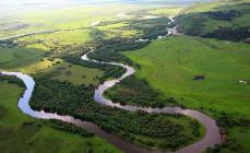
IN Caspian Sea 130 rivers flow into it, of which 9 rivers have a mouth in the form of a delta. Large rivers flowing into the Caspian Sea are the Volga, Terek (Russia), Ural, Emba (Kazakhstan), Kura (Azerbaijan), Samur (Russian border with Azerbaijan), Atrek (Turkmenistan) and others.
Map of the Caspian Sea
The Caspian Sea washes the shores of five coastal states:
Russia (Dagestan, Kalmykia and Astrakhan region) - in the west and northwest, the length of the coastline is 695 kilometers
Kazakhstan - in the north, northeast and east, the length of the coastline is 2320 kilometers
Turkmenistan - in the southeast, the length of the coastline is 1200 kilometers
Iran - in the south, the length of the coastline - 724 kilometers
Azerbaijan - in the southwest, the length of the coastline is 955 kilometers
Water temperature
is subject to significant latitudinal changes, most pronounced in winter, when the temperature varies from 0 - 0.5 °C at the ice edge in the north of the sea to 10 - 11 °C in the south, that is, the water temperature difference is about 10 °C. For shallow water areas with depths less than 25 m, the annual amplitude can reach 25 - 26 °C. The average water temperature at west coast 1 - 2 °C higher than that of the eastern, and in the open sea the water temperature is 2 - 4 °C higher than that of the coasts.
Climate of the Caspian Sea- continental in the northern part, temperate in the middle part and subtropical in the southern part. In winter, the average monthly temperature of the Caspian varies from -8 -10 in the northern part to +8 - +10 in the southern part, in summer - from +24 - +25 in the northern part to +26 - +27 in the southern part. The maximum temperature recorded on the east coast is 44 degrees.
Animal world
The fauna of the Caspian is represented by 1809 species, of which 415 are vertebrates. IN Caspian Sea 101 species of fish have been registered, and most of the world's sturgeon stocks are concentrated in it, as well as such freshwater fish as roach, carp, pike perch. Caspian Sea- habitat for fish such as carp, mullet, sprat, kutum, bream, salmon, perch, pike. IN Caspian Sea also inhabited by a marine mammal - the Caspian seal.
Vegetable world
Vegetable world Caspian Sea and its coast is represented by 728 species. From plants to Caspian Sea algae predominate - blue-green, diatoms, red, brown, char and others, from flowering ones - zoster and ruppia. By origin, the flora belongs mainly to the Neogene age, however, some plants were brought into Caspian Sea by a person consciously or on the bottoms of ships.
Mining of oil and gas
IN Caspian Sea many oil and gas fields are being developed. Proven oil resources in Caspian Sea are about 10 billion tons, the total resources of oil and gas condensate are estimated at 18 - 20 billion tons.
Oil production in Caspian Sea began in 1820, when the first oil well was drilled on the Absheron shelf. In the second half of the 19th century, oil production began on an industrial scale on the Absheron Peninsula, and then on other territories.
In addition to oil and gas production, on the coast Caspian Sea and the Caspian shelf, salt, limestone, stone, sand, and clay are also being mined.
Ecological problems
Ecological problems Caspian Sea associated with water pollution as a result of oil production and transportation on the continental shelf, the flow of pollutants from the Volga and other rivers flowing into Caspian Sea, the vital activity of coastal cities, as well as the flooding of individual facilities due to an increase in the level Caspian Sea. Predatory harvesting of sturgeons and their caviar, rampant poaching lead to a decrease in the number of sturgeons and forced restrictions on their production and export.
The territory of Russia is washed by twelve seas belonging to the basins of three oceans. But one of these seas - the Caspian - is often called a lake, which sometimes confuses people who are poorly versed in geography.
Meanwhile, it is really more correct to call the Caspian a lake, not a sea. Why? Let's figure it out.
A bit of geography. Where is the Caspian Sea located?
Occupying an area that exceeds 370,000 square kilometers, the Caspian Sea stretches from north to south, dividing Europe and Asia with its water surface. Its coastline belongs to five different countries: Russia, Kazakhstan, Azerbaijan, Turkmenistan and Iran. Geographers conditionally divide its water area into three parts: Northern (25% of the area), Middle (36% of the area) and South Caspian (39% of the area), which differ in climate, geological setting and natural features. Coastline mostly gentle, indented by river channels, covered with vegetation, and in the northern part, where the Volga flows into the Caspian, it is also swampy.
The Caspian Sea has about 50 large and small islands, about a dozen bays and six large peninsulas. In addition to the Volga, about 130 rivers flow into it, and nine rivers form fairly wide and branched deltas. The annual drainage of the Volga is about 120 cubic kilometers. Together with other large rivers - the Terek, the Urals, the Emba and the Sulak - this accounts for up to 90% of the total annual runoff to the Caspian.
Why is the Caspian called a lake?
The main feature of any sea is the presence of straits connecting it with the ocean. The Caspian is a closed, or endorheic body of water, which receives river water, but does not connect with any ocean. 
Its water contains a very small amount of salt compared to other seas (about 0.05%) and is considered slightly salty. Due to the lack of at least one strait connecting to the ocean, the Caspian is often called the largest lake in the world, since the lake is a completely closed reservoir, which is fed only by river water.
The waters of the Caspian Sea are not subject to international maritime laws, and its water area is divided among all countries that adjoin it, in proportion to the coastline.
Why is the Caspian called the sea?
Despite all of the above, most often in geography, as well as in international and domestic documents, the name “Caspian Sea” is used, and not “ Caspian lake". First of all, this is due to the size of the reservoir, which is much more typical for the sea than for the lake. Even, which is much smaller in area than the Caspian, locals often referred to as the sea. There are no other lakes in the world whose shores belong to five different countries at the same time.
In addition, attention should be paid to the structure of the bottom, which near the Caspian Sea has a pronounced oceanic type. Once the Caspian Sea, most likely, was connected with the Mediterranean, but tectonic processes and drying up separated it from the World Ocean. More than fifty islands are located in the Caspian Sea, and the area of some of them is quite large, even by international standards they are considered large. All this makes it possible to call the Caspian a sea, not a lake.
origin of name
Why is this sea (or lake) called Caspian? The origin of any name is often associated with ancient history terrain. Different peoples who lived on the shores of the Caspian called it differently. More than seventy names of this reservoir have been preserved in history - it was called the Hyrcanian, Derbent, Sarai Sea, etc. 
Iranians and Azerbaijanis still call it the Khazar Sea. It began to be called Caspian by the name of the ancient tribe of nomadic horse breeders who lived in the steppes adjacent to its coast - a large tribe of Caspians. It was they who gave the name to large lake on our planet - the Caspian Sea.
, Kazakhstan, Turkmenistan, Iran , Azerbaijan
Geographical position

Caspian Sea - view from space.
The Caspian Sea is located at the junction of two parts of the Eurasian continent - Europe and Asia. The length of the Caspian Sea from north to south is approximately 1200 kilometers (36°34 "-47°13" N), from west to east - from 195 to 435 kilometers, on average 310-320 kilometers (46°-56° v. d.).
The Caspian Sea is conditionally divided according to physical and geographical conditions into 3 parts - the North Caspian, the Middle Caspian and the South Caspian. The conditional border between the North and Middle Caspian runs along the line of about. Chechnya - Cape Tyub-Karagansky, between the Middle and South Caspian - along the line of about. Residential - Cape Gan-Gulu. The area of the Northern, Middle and Southern Caspian is 25, 36, 39 percent respectively.
Coast of the Caspian Sea

Coast of the Caspian Sea in Turkmenistan
The territory adjacent to the Caspian Sea is called the Caspian Sea.
Peninsulas of the Caspian Sea
- Ashur-Ada
- Garasu
- Zyanbil
- Hara Zira
- Sengi-Mugan
- Chygyl
Bays of the Caspian Sea
- Russia (Dagestan, Kalmykia and Astrakhan region) - in the west and north-west, the length of the coastline is about 1930 kilometers
- Kazakhstan - in the north, northeast and east, the length of the coastline is about 2320 kilometers
- Turkmenistan - in the southeast, the length of the coastline is about 650 kilometers
- Iran - in the south, the length of the coastline is about 1000 kilometers
- Azerbaijan - in the southwest, the length of the coastline is about 800 kilometers
Cities on the coast of the Caspian Sea
On the Russian coast there are cities - Lagan, Makhachkala, Kaspiysk, Izberbash and the most Southern City Russian Derbent. Astrakhan is also considered a port city of the Caspian Sea, which, however, is not located on the shores of the Caspian Sea, but in the Volga Delta, 60 kilometers from the northern coast of the Caspian Sea.
Physiography
Area, depth, volume of water
The area and volume of water in the Caspian Sea varies significantly depending on fluctuations in water levels. At a water level of -26.75 m, the area is approximately 371,000 square kilometers, the volume of water is 78,648 cubic kilometers, which is approximately 44% of the world's lake water reserves. The maximum depth of the Caspian Sea is in the South Caspian depression, 1025 meters from its surface level. In terms of maximum depth, the Caspian Sea is second only to Baikal (1620 m) and Tanganyika (1435 m). The average depth of the Caspian Sea, calculated from the bathygraphic curve, is 208 meters. At the same time, the northern part of the Caspian Sea is shallow, its maximum depth does not exceed 25 meters, and the average depth is 4 meters.
Water level fluctuations
Vegetable world
The flora of the Caspian Sea and its coast is represented by 728 species. Of the plants in the Caspian Sea, algae predominate - blue-green, diatoms, red, brown, char and others, of flowering - zoster and ruppia. By origin, the flora belongs mainly to the Neogene age, however, some plants were brought into the Caspian Sea by man either consciously or on the bottoms of ships.
History of the Caspian Sea
Origin of the Caspian Sea
Anthropological and cultural history of the Caspian Sea
Finds in the Khuto cave near the southern coast of the Caspian Sea indicate that a person lived in these parts about 75 thousand years ago. The first mention of the Caspian Sea and the tribes living on its coast are found in Herodotus. Approximately in the V-II centuries. BC e. Saka tribes lived on the coast of the Caspian Sea. Later, during the period of the settlement of the Turks, in the period of the 4th-5th centuries. n. e. Talysh tribes (Talysh) lived here. According to ancient Armenian and Iranian manuscripts, the Russians sailed the Caspian Sea from the 9th-10th centuries.
Exploration of the Caspian Sea
The exploration of the Caspian Sea was started by Peter the Great, when, on his orders, an expedition was organized in 1714-1715 under the leadership of A. Bekovich-Cherkassky. In the 1720s, hydrographic studies were continued by the expedition of Karl von Werden and F.I. Soymonov, later by I.V. Tokmachev, M.I. Voinovich and other researchers. At the beginning of the 19th century, instrumental surveying of the banks was carried out by I.F. Kolodkin, in the middle of the 19th century. - instrumental geographic survey under the direction of N. A. Ivashintsev. Since 1866, for more than 50 years, expeditionary research on the hydrology and hydrobiology of the Caspian Sea has been carried out under the leadership of N. M. Knipovich. In 1897, the Astrakhan Research Station was founded. In the first decades of Soviet power in the Caspian Sea, geological research by I. M. Gubkin and other Soviet geologists was actively carried out, mainly aimed at finding oil, as well as research on the study of the water balance and fluctuations in the level of the Caspian Sea.
Economy of the Caspian Sea
Mining of oil and gas
Many oil and gas fields are being developed in the Caspian Sea. The proven oil resources in the Caspian Sea are about 10 billion tons, the total resources of oil and gas condensate are estimated at 18-20 billion tons.
Oil production in the Caspian Sea began in 1820, when the first oil well was drilled on the Absheron shelf near Baku. In the second half of the 19th century, oil production began on an industrial scale on the Absheron Peninsula, and then on other territories.
Shipping
Shipping is developed in the Caspian Sea. Ferry crossings operate on the Caspian Sea, in particular, Baku - Turkmenbashi, Baku - Aktau, Makhachkala - Aktau. The Caspian Sea has a navigable connection with the Sea of Azov through the Volga and Don rivers and the Volga-Don Canal.
Fishing and seafood
Fishing (sturgeon, bream, carp, pike perch, sprat), caviar, and seal fishing. More than 90 percent of the world's sturgeon catch is carried out in the Caspian Sea. In addition to industrial production, illegal production of sturgeon and their caviar flourishes in the Caspian Sea.
Recreational resources
The natural environment of the Caspian coast with sandy beaches, mineral waters and therapeutic mud in the coastal zone creates good conditions for rest and treatment. At the same time, in terms of the degree of development of resorts and the tourism industry, the Caspian coast noticeably loses to the Black Sea coast of the Caucasus. At the same time, in recent years, the tourism industry has been actively developing on the coast of Azerbaijan, Iran, Turkmenistan and Russian Dagestan. Azerbaijan is actively developing resort area in the Baku region. At the moment, a world-class resort has been created in Amburan, another modern tourist complex is being built near the village of Nardaran, recreation in the sanatoriums of the villages of Bilgah and Zagulba is very popular. A resort area is also being developed in Nabran, in the north of Azerbaijan. However, high prices, a generally low level of service and a lack of advertising lead to Caspian resorts almost no foreign tourists. The development of the tourism industry in Turkmenistan is hampered by a long policy of isolation, in Iran - by Sharia law, due to which the mass vacation of foreign tourists on the Caspian coast of Iran is impossible.
Ecological problems
The environmental problems of the Caspian Sea are associated with water pollution as a result of oil production and transportation on the continental shelf, the flow of pollutants from the Volga and other rivers flowing into the Caspian Sea, the vital activity of coastal cities, as well as the flooding of individual objects due to the rise in the level of the Caspian Sea. Predatory harvesting of sturgeons and their caviar, rampant poaching lead to a decrease in the number of sturgeons and forced restrictions on their production and export.
International status of the Caspian Sea
Legal status of the Caspian Sea
After the collapse of the USSR, the division of the Caspian Sea for a long time was and still remains the subject of unsettled disagreements related to the division of the resources of the Caspian shelf - oil and gas, as well as biological resources. For a long time there were negotiations between the Caspian states on the status of the Caspian Sea - Azerbaijan, Kazakhstan and Turkmenistan insisted on dividing the Caspian along the median line, Iran - on dividing the Caspian along one fifth between all the Caspian states.
With regard to the Caspian Sea, the key is the physical and geographical circumstance that it is a closed inland water body that does not have a natural connection with the World Ocean. Accordingly, the norms and concepts of international maritime law, in particular, the provisions of the UN Convention on the Law of the Sea of 1982, should not automatically apply to the Caspian Sea. Based on this, it would be unlawful to apply such concepts as “territorial sea”, “exclusive economic zone”, “continental shelf”, etc.
The current legal regime of the Caspian Sea was established by the Soviet-Iranian treaties of 1921 and 1940. These treaties provide for freedom of navigation throughout the sea, freedom of fishing, with the exception of ten-mile national fishing zones, and a ban on navigation in its waters of ships flying the flag of non-Caspian states.
Negotiations on the legal status of the Caspian are currently ongoing.
Delimitation of sections of the bottom of the Caspian Sea for the purpose of subsoil use
The Russian Federation concluded an agreement with Kazakhstan on the delimitation of the bottom of the northern part of the Caspian Sea in order to exercise sovereign rights to subsoil use (dated July 6, 1998 and the Protocol dated May 13, 2002), an agreement with Azerbaijan on the delimitation of adjacent sections of the bottom of the northern part of the Caspian Sea (dated September 23, 2002), as well as the trilateral Russian-Azerbaijani-Kazakhstan agreement on the junction of the demarcation lines of adjacent sections of the Caspian Sea bottom (dated May 14, 2003), which established geographical coordinates dividing lines delimiting seabed areas within which the parties exercise their sovereign rights in the field of exploration and extraction of mineral resources.
CaspAndmOre(Caspian) - the largest enclosed body of water on Earth. In size, the Caspian Sea is much larger than such lakes as the Upper, Victoria, Huron, Michigan, Baikal. According to formal features, the Caspian Sea is an endorheic lake. However, given its large size, brackish waters and sea-like regime, this body of water is called the sea.
According to one hypothesis, the Caspian Sea (among the ancient Slavs - the Khvalyn Sea) got its name in honor of the Caspian tribes who lived before our era on its southwestern coast.
The Caspian Sea washes the shores of five states: Russia, Azerbaijan, Iran, Turkmenistan and Kazakhstan.
The Caspian Sea is elongated in the meridional direction and is located between 36°33' and 47°07' N latitude. and 45°43΄ and 54°03΄ E (without Kara-Bogaz-Gol Bay). The length of the sea along the meridian is about 1200 km; the average width is 310 km. The northern coast of the Caspian Sea is bordered by the Caspian lowland, the eastern coast by the deserts of Central Asia; in the west, the mountains of the Caucasus approach the sea, in the south, near the coast, the Elburz ridge stretches.
The surface of the Caspian Sea is much lower than the level of the World Ocean. Its current level fluctuates around -27 ... -28 m. These levels correspond to the sea surface area of 390 and 380 thousand km 2 (without the Kara-Bogaz-Gol Bay), the volume of water is 74.15 and 73.75 thousand km 3, average depth is about 190 m.
The Caspian Sea is traditionally divided into three large parts: the North (24% of the sea area), the Middle (36%) and the South Caspian (40%), which differ significantly in morphology and regime, as well as the large and isolated Kara-Bogaz-Gol Bay. The northern, shelf part of the sea is shallow: its average depth is 5–6 m, maximum depths are 15–25 m, and the volume is less than 1% of the total water mass of the sea. The Middle Caspian is a separate basin with the area of maximum depths in the Derbent depression (788 m); its average depth is about 190 m. In the South Caspian, the average and maximum depths are 345 and 1025 m (in the South Caspian depression); 65% of the water mass of the sea is concentrated here.
There are about 50 islands in the Caspian Sea with a total area of approximately 400 km2; the main ones are Tyuleniy, Chechen, Zyudev, Konevsky, Dzhambaysky, Durneva, Ogurchinsky, Apsheronsky. The length of the coastline is approximately 6.8 thousand km, with islands - up to 7.5 thousand km. The shores of the Caspian Sea are diverse. In the northern and eastern parts, they are quite strongly indented. There are large bays Kizlyarsky, Komsomolets, Mangyshlaksky, Kazakhsky, Kara-Bogaz-Gol, Krasnovodsky and Turkmensky, many bays; off the western coast - Kyzylagach. Most large peninsulas- Agrakhansky, Buzachi, Tyub-Karagan, Mangyshlak, Krasnovodsky, Cheleken and Apsheronsky. The most common banks are accumulative; areas with abrasion shores are found along the contour of the Middle and South Caspian.
More than 130 rivers flow into the Caspian Sea, the largest of which is the Volga. , Ural, Terek, Sulak, Samur, Kura, Sefidrud, Atrek, Emba (its runoff enters the sea only in high-water years). Nine rivers have deltas; the largest are located at the mouths of the Volga and Terek.
The main feature of the Caspian Sea, as a drainless reservoir, is instability and a wide range of long-term fluctuations in its level. This most important hydrological feature of the Caspian Sea has a significant impact on all its other hydrological characteristics, as well as on the structure and regime of river mouths, on coastal zones. In the Caspian Sea level varied in the range of ~200 m: from -140 to +50 m BS; in from -34 to -20 m BS. From the first third of the 19th century and until 1977, sea level dropped by about 3.8 m - to the lowest point in the last 400 years (-29.01 m BS). In 1978–1995 The level of the Caspian Sea rose by 2.35 m and reached -26.66 m BS. Since 1995, a certain downward trend has dominated - to -27.69 m BS in 2013.
During major periods, the northern shore of the Caspian Sea shifted to Samarskaya Luka on the Volga, and perhaps even further. At maximum transgressions, the Caspian turned into a sewage lake: excess water flowed through the Kuma-Manych depression into the Sea of Azov and further into the Black Sea. In extreme regressions South coast The Caspian was shifted to the Apsheron threshold.
Long-term fluctuations in the level of the Caspian are explained by changes in the structure of the water balance of the Caspian Sea. The sea level rises when the incoming part of the water balance (primarily river runoff) increases and exceeds the outgoing part, and decreases if the inflow of river waters decreases. The total water flow of all rivers averages 300 km 3 /year; while the five largest rivers account for almost 95% (the Volga provides 83%). During the period of the lowest sea level, in 1942–1977, the river flow was 275.3 km 3 / year (of which 234.6 km 3 / year is the flow of the Volga), precipitation - 70.9, underground flow - 4 km 3 /year, and evaporation and outflow to the Kara-Bogaz-Gol Bay - 354.79 and 9.8 km 3 /year. During the period of intensive sea level rise, in 1978-1995, respectively, 315 (Volga - 274.1), 86.1, 4, 348.79 and 8.7 km 3 / year; in the modern period - 287.4 (Volga - 248.2), 75.3, 4, 378.3 and 16.3 km 3 / year.
The intra-annual changes in the level of the Caspian Sea are characterized by a maximum in June–July and a minimum in February; the range of intra-annual level fluctuations is 30–40 cm. Surge-surge level fluctuations are manifested throughout the sea, but they are most significant in the northern part, where, with maximum surges, the level can rise by 2–4.5 m and the edge “retreat” by several tens of kilometers inland, and in case of surges - to drop by 1–2.5 m. Seiche and tidal level fluctuations do not exceed 0.1–0.2 m.
Despite the relatively small size of the reservoir in the Caspian Sea, there is strong excitement. highest heights waves in the South Caspian can reach 10–11 m. Wave heights decrease in the direction from south to north. Storm waves can develop at any time of the year, but more often and more dangerously in the cold half of the year.
The Caspian Sea is generally dominated by wind currents; nevertheless, on the estuarine coasts major rivers runoff currents play a significant role. Cyclonic water circulation prevails in the Middle Caspian, and anticyclonic circulation in the South Caspian. In the northern part of the sea, the patterns of wind currents are more irregular and depend on the characteristics and variability of the wind, bottom topography and coastlines, river runoff and aquatic vegetation.
The water temperature is subject to significant latitudinal and seasonal changes. In winter, it varies from 0–0.5 o C at the ice edge in the north of the sea to 10–11 o C in the south. In summer, the water temperature in the sea averages 23–28 o C, and in shallow coastal waters in the Northern Caspian it can reach 35–40 o C. At depths, a constant temperature is maintained: deeper than 100 m it is 4–7 o C.
In winter, only the northern part of the Caspian Sea freezes; in severe winter - the entire Northern Caspian and coastal zones Middle Caspian. Freezing in the Northern Caspian lasts from November to March.
The salinity of water changes especially sharply in the northern part of the sea: from 0.1‰ on the estuarine coasts of the Volga and Urals to 10–12‰ on the border with the Middle Caspian. In the Northern Caspian, the temporal variability of water salinity is also great. In the middle and southern parts In the sea, salinity fluctuations are small: basically it is 12.5–13.5‰, increasing from north to south and from west to east. The highest water salinity is in the Kara-Bogaz-Gol Bay (up to 300‰). With depth, the salinity of water increases slightly (by 0.1–0.3‰). The average salinity of the sea is about 12.5‰.
More than a hundred species of fish live in the Caspian Sea and the mouths of the rivers flowing into it. There are Mediterranean and Arctic invaders. Gobies, herring, salmon, carp, mullet and sturgeon fish serve as the object of fishing. The latter number five species: sturgeon, beluga, stellate sturgeon, spike and sterlet. The sea is capable of producing up to 500-550 thousand tons of fish annually if overfishing is not allowed. Of the marine mammals, the endemic Caspian seal lives in the Caspian Sea. Every year 5-6 million waterfowl migrate through the Caspian region.
The economy of the Caspian Sea is associated with oil and gas production, shipping, fishing, seafood, various salts and minerals (Kara-Bogaz-Gol Bay), using recreational resources. The explored oil resources in the Caspian Sea are about 10 billion tons, the total resources of oil and gas condensate are estimated at 18–20 billion tons. Oil and gas are being produced on an ever-increasing scale. Used by the Caspian Sea and water transport, including along the river-sea and sea-river routes. The main ports of the Caspian Sea: Astrakhan, Olya, Makhachkala (Russia), Aktau, Atyrau (Kazakhstan), Baku (Azerbaijan), Nowshahr, Bender-Enzeli, Bender-Torkemen (Iran) and Turkmenbashi (Turkmenistan).
The economic activity and hydrological features of the Caspian Sea create a number of serious environmental and water management problems. Among them: anthropogenic pollution of river and sea waters (mainly with oil products, phenols and synthetic surfactants), poaching and reduction of fish stock, especially sturgeons; damage to the population and coastal economic activity due to large-scale and rapid changes in the level of the reservoir, the impact of numerous hazardous hydrological phenomena and hydrological and morphological processes.
The total economic damage for all the Caspian countries associated with the rapid and significant recent rise in the level of the Caspian Sea, the flooding of part of the coastal land, the destruction of coasts and coastal structures, was estimated at 15 to 30 billion US dollars. It took urgent engineering measures to protect the coast.
A sharp drop in the level of the Caspian Sea in the 1930s–1970s. led to less damage, but they were significant. The navigable approach channels became shallow, the shallow seashore at the mouths of the Volga and the Urals became heavily overgrown, which became an obstacle to the passage of fish into the rivers for spawning. It was necessary to build fish passages through the seasides mentioned above.
Among the unresolved problems is the lack of an international agreement on the international legal status of the Caspian Sea, the division of its water area, bottom and subsoil.
The Caspian Sea is the object of many years of research by specialists of all littoral states. Such domestic organizations as the State Oceanographic Institute, the Institute of Oceanology of the Russian Academy of Sciences, the Hydrometeorological Center of Russia, the Caspian Research Institute of Fisheries, the Faculty of Geography of Moscow State University, etc. took an active part in the study of the Caspian Sea.
Many geographical names, can mislead people who are not fond of geography. Could it be that the object marked on all maps as the sea is in fact a lake? Let's figure it out.
The history of the appearance of the Caspian Sea?
14,000,000 years ago, the Sarmatian Sea existed on the planet. It included modern, Black, Caspian and Sea of Azov. About 6,000,000 years ago, due to the rise of the Caucasus Mountains and the lowering of the water level in the Mediterranean Sea, it split, forming four different seas.
The Caspian is inhabited by many representatives of the fauna of Azov, which once again confirms that once these reservoirs were one. This is one of the reasons why the Caspian Sea is considered a lake.
The name of the sea comes from the ancient tribes of the Caspians. They inhabited its shores in the first millennia BC and were engaged in horse breeding. But over the long hundreds of years of its existence, this sea has had many names. It was called Derbent, Sarai, Girkan, Sigay, Kukkuz. Even in our time, for the inhabitants of Iran and Azerbaijan, this lake is called Khazar.
Geographic location
Two parts of the world - Europe and Asia, are washed by the waters of the Caspian Sea. The coastline covers the following countries:
- Turkmenistan
- Russia
- Azerbaijan
- Kazakhstan
The length from north to south is about one thousand two hundred kilometers, the width from west to east is about three hundred kilometers. The average depth is about two hundred meters, the greatest depth is about a thousand kilometers. total area the reservoir is more than 370,000 square kilometers and is divided into three climatic and geographical zones:
- Northern
- Average
- South Caspian
The water area has six large peninsulas and about fifty islands. Their total area is four hundred square kilometers. The largest islands are Dzhambaisky, Ogurchinsky, Chechen, Tyuleniy, Konevsky, Zyudev and Absheron Islands. About one hundred and thirty rivers flow into the Caspian, including the Volga, Ural, Atrek, Sefirud, Terek, Kura and many others.
Sea or lake?
The official name used in documentation and cartography is the Caspian Sea. But is this true?
In order to have the right to be called a sea, any body of water must be connected to the oceans. In the case of the Caspian, this is not the reality. From the nearest sea, the Black Sea, the Caspian Sea is separated by almost 500 km of land. This is a completely enclosed reservoir. The main differences of the seas:
- The seas can be fed by water arteries - rivers.
- The outer seas are directly connected with the ocean, that is, they have access to it.
- The inland seas are connected to other seas or oceans by straits.
The Caspian received the right to be called a sea primarily because of its impressive size, which is more characteristic of seas rather than lakes. In terms of area, it surpasses even Azov. Also, the fact that not a single lake washes the shores of five states at once played a significant role.
It should be noted that the structure of the bottom of the Caspian Sea belongs to the oceanic type. This happened due to the fact that it was once part of the ancient oceans.
Compared to other seas, the percentage of salt saturation in it is very weak and does not exceed 0.05%. The Caspian is fed only by rivers flowing into it, like all lakes on the globe.
Like many seas, the Caspian is famous for its powerful storms. The height of the waves can reach eleven meters. Storms can occur at any time of the year, but they are most dangerous in autumn and winter.
In fact, the Caspian Sea is the most big lake in the world. Its waters are not subject to international maritime laws. The territory of the waters is divided between countries on the basis of laws adopted for lakes, and not for seas.
The Caspian Sea has rich mineral resources such as oil and gas. Its waters are inhabited by more than one hundred and twenty species of fish. Among them are the most valuable sturgeons, such as stellate sturgeon, sturgeon, sterlet, beluga, and spike. 90% of the world's sturgeon catch goes to the Caspian Sea.
Interesting features:
- Scientists around the world have not come to an unambiguous opinion why the Caspian Sea is considered a lake. Some experts even suggest considering it a "lake-sea" or "inland" sea, like the Dead Sea in Israel;
- The deepest point of the Caspian is more than one kilometer;
- Historically, it is known that the general water level in the reservoir has changed more than once. The exact reasons for this are still not understood;
- This is the only body of water separating Asia and Europe;
- The largest waterway that feeds the lake is the Volga River. It is she who carries the bulk of the water;
- Thousands of years ago the Caspian Sea was part of the Black Sea;
- In terms of the number of fish species, the Caspian Sea loses to some rivers;
- The Caspian Sea is the main supplier of the most expensive delicacy - black caviar;
- The water in the lake is completely renewed every two hundred and fifty years;
- Territory of Japan less area the Caspian Sea.
Ecological situation
Intervention in the ecology of the Caspian Sea regularly occurs due to the extraction of oil and natural resources. There are also interventions in the fauna of the reservoir, cases of poaching and illegal catching of valuable species of fish are frequent.
The water level in the Caspian Sea is falling every year. This is due to global warming, due to the influence of which the water temperature on the surface of the reservoir increased by one degree and the sea began to actively evaporate.
It is estimated that the water level has fallen by seven centimeters since 1996. By 2015, the fall was about one and a half meters, and the water continues to fall.
If this continues, in a century the smallest part of the lake may simply disappear. This will be the part that washes the borders of Russia and Kazakhstan. In the case of increased global warming, the process can accelerate and this will happen much earlier.
It is known that long before the onset of global warming, the water level in the Caspian was undergoing changes. The water stayed and then fell. Scientists still cannot say exactly why this happened.