Karachay-Cherkess Republic (Karachay-Cherkess Republic; Karachay-Cherkess Republic, Kabard-Cherkess Republic, Karacha-Cherkess Republic, Karachay-Cherkess Republic, Leg. Karachay-Sherkesh Republic) is a republic within the Russian Federation, subject of the Russian Federation, part of the North Caucasus Federal District.
The capital is the city of Cherkessk.
It borders in the west with the Krasnodar Territory, in the north with the Stavropol Territory, in the east with the Kabardino-Balkarian Republic, in the south along the Main Caucasus Range with Georgia, as well as with Abkhazia (which is a partially recognized state; at the same time, according to the administrative territorial division of Georgia, is part of Georgia).

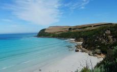
A ski and tourist resort praised by Vizbor. It is interesting primarily because many famous peaks (Belalakaya, Zub, Sofrudzhu, Ertsog, etc.) are visible directly from the village in all their glory. If there is a place in the world that is “better to see once,” then this is, of course, Dombay - a country of blue skies, generous sun and snowy peaks, a country sung by poets. Throughout the history of Dombay, quite a few of them have visited here, as have artists and musicians, or even just people in love with the mountains, “sick” of the mountains. The world-famous Dombay glade, located at an altitude of 1650 m above sea level, in the heart of the mountains, is formed by the mouths of the Amanauz (Evil Mouth) and its two tributaries - Alibek and Dombay-Yolgen. These rivers originate at the peaks of the same name. The last one, Dombay-Yolgen (Killed Bison), gave the name to Dombay itself (in Karachay “dommai” means “bison”).
Dombay is not an administrative concept, and its boundaries do not have strictly defined boundaries. This is a modern, although rooted in tradition, name for the upper reaches of the Teberda River, a large tributary of the Kuban, uniting several mountain gorges originating from the Main Caucasus Range. The word “dombai” (dommai) means “bison” in Karachay; once upon a time, entire herds of mighty giants roamed the Dombay forests.
Dombay is one of the modern centers of recreation and sports, a mountaineering, skiing and tourist Mecca of the Greater Caucasus. With the advent of a market economy in Russia, the hotel industry has undergone rapid development. Currently, a tourist complex of several dozen hotels, including modern mini-hotels, operates in Dombayskaya Polyana.
Sofrudzhinsky waterfall 
Mount Dombay-Ulgen
Dombay-Yolgen is the top of the western part of the Main, or Watershed, ridge of the Greater Caucasus (on the border of Abkhazia and the Karachay-Cherkess Republic), at the source of the Teberda River. The height is 4046 m, this is the highest point in Abkhazia. It is composed of gneisses, crystalline schists, and granites. Covered with eternal snow and glaciers.
Dombay-Ulgen is the highest peak of Dombay, located east of the village of Dombay, has three peaks: western (4036 m), main (4046 m) and eastern (3950 m). A steep ridge extends from the main peak to the north, ending in a depression - the “Dombay saddle”. From the Dombai Col there is a classic route (category 3B), accessible for climbing in one day with a descent to the camp located either at the Dombai Col site or the Ptysh bivouac. In 1960, a mountaineering expedition of 4 people, led by Igor Erokhin, died on the top of Dombay-Ulgen.
GPS coordinates: N43.24406 E41.72571
Address of Dombay village.

Klukhor Pass
Pass on the Military-Sukhumi road at an altitude of 2781 m through the Main Caucasus ridge. It was also described by ESBE: “A stone path was built along the Kodor gorge through the Klukhorsky pass in the main Caucasian ridge, to connect Sukhum with Cherkessk.” Leads from the Kodor basin to the upper reaches of the Kuban. The Kodor and Teberda rivers flow through.
Klukhorsky pass is the highest mountain section of the Military-Sukhumi road. Its section leading through the Klukhor Pass is currently not suitable for automobile traffic. Transport communications along the Military-Sukhumi Road depend on the weather in this section. In winter, snow drifts are frequent here. After the armed Georgian-Abkhaz conflict of 1992-1993, through traffic on the road was closed.
A very picturesque road along its entire length with steep serpentines rises along the Gonachkhir River, which runs in a powerful stream to meet Amanauz. The place of their confluence is considered the beginning of Teberda. From the road there is a view of the gorges of the Bu-Yolgen, Chotcha, Khakol, Northern Klukhor rivers, originating from the powerful glaciers of the peaks of the same name. The road leads to Lake Tubanly-Kel (Misty Lake), also called Trout Lake. It is located at an altitude of 1850m. Its length is 275 m, width - 120 m. The lake is cold and deep, but on hot days the water warms up and you can swim.
GPS coordinates: N43.24416 E41.86527
Address Dombay.
Alibeksky Waterfall
One of the largest and most spectacular waterfalls in Dombai, Karachay-Cherkessia. The height of the waterfall is more than 25 meters. The waterfall is formed by the fall of the Dzhalovchatka river from the Alibek glacier; The stones from which water falls are called “ram’s foreheads.”
Alibek waterfall appeared in the 20th century. Back in the 1930s, there was no waterfall, and the rocky ledge was covered by the tongue of the Alibek glacier, which retreats upward by a meter and a half every year. A popular hiking destination. Located on the territory of the Teberda Nature Reserve. Nearest settlements: Alibek alpine camp (approximately 2 km), Dombay village (approximately 7 km).
GPS coordinates: N43.29726 E41.55754
Address Dombay, Alibek river valley.
Dombai glade
It is located surrounded by mountain ranges at the intersection of the Dombay-Ulgen, Amanauz and Alibek rivers at an altitude of about 1600 meters above sea level. Beautiful panoramic views, the starting point of many excursion routes.
GPS coordinates: N43.29104 E41.62173
Address of the village Dombay.

History of Karachay-Cherkessia
At the end of the first millennium AD, the territory of Karachay-Cherkessia was part of the state of the Alans; individual architectural monuments of that time have been preserved: Zelenchuk, Sentinsky, Shoanin Christian churches, fortifications. Since the first half of the 19th century (according to the Russian-Turkish Treaty of Adrianople in 1828), the territory of modern Karachay-Cherkessia has been part of Russia as the Batalpashinsky department of the Kuban region.
Since 1918, Soviet power has been established here. From April 1, 1918, the territory was part of the Kuban Soviet Republic, from May 28, 1918 - part of the Kuban-Black Sea Soviet Republic, from July 5 to December 1918 - part of the North Caucasus Soviet Republic. From December 1918 to April 1920 it was controlled by the White Guard AFSR. Since January 20, 1921 - part of the Mountain Autonomous Soviet Socialist Republic.
On January 12, 1922, the Karachay-Cherkess Autonomous Region was formed as part of the South-Eastern (since 1924 - North Caucasus) region, with its center in the village of Batalpashinskaya (later renamed the city of Sulimov, Ezhovo-Cherkessk and, finally, received the modern name Cherkessk) .
On April 26, 1926, by a decree of the All-Russian Central Executive Committee, the KChAO was divided into the Karachay Autonomous Region, the Circassian National District (from April 30, 1928 - an autonomous region), Batalpashinsky and Zelenchuksky districts.

By decree of the Presidium of the Supreme Soviet of the USSR, the Karachay Autonomous Region was liquidated on October 12, 1943, and the Karachays were recognized as accomplices of the fascist troops and on November 2, 1943, deported to Central Asia and Kazakhstan. The southern part of Karachay went to Georgia (as the Klukhorsky district), and most of it was annexed to the Stavropol Territory.
After the rehabilitation of the Karachais with permission to return to their native lands, on January 12, 1957, the Cherkess Autonomous Region was transformed into the Karachay-Cherkess Autonomous Okrug as part of the Stavropol Territory. Zelenchuksky, Karachaevsky and Ust-Dzhegutinsky districts of the Stavropol Territory were also transferred to her.
to form the Urupsky district - the center is the village of Pregradnaya.
abolish the Urup industrial region of the Karachay-Cherkess Autonomous Region
Adyge-Khablsky, Zelenchuksky, Karachayevsky, Malokarachayevsky, Prikubansky and Khabezsky rural areas of the Karachay-Cherkess Autonomous Region should be transformed into districts.
On November 30, 1990, the Council of People's Deputies of the Karachay-Cherkess Autonomous Region decided to secede from the Stavropol Territory and transform into the Karachay-Cherkess Soviet Socialist Republic (KCSSR) within the RSFSR, which was approved by the RSFSR Law of July 3, 1991 No. 1537-1 .
In 1989-1991, congresses of individual peoples of Karachay-Cherkessia, convened by national movements, began to appeal to the leadership of the RSFSR with a request for the restoration or creation of individual autonomies.
At congresses of deputies of all levels the following were proclaimed:
November 18, 1990 - Karachay Soviet Socialist Republic (since October 17, 1991 - Karachay Republic),
in November 1991 - the Abaza Republic,
August 19, 1991 - Batalpashinskaya Cossack Republic and Zelenchuk-Urupskaya Cossack Soviet Socialist Republic (November 30, 1991 united into the Upper Kuban Cossack Republic).
After many days of thousands of rallies, on December 3, 1991, by resolution of the Supreme Council of Karachay-Cherkessia, an appeal was adopted to the federal center to recognize individual republics.
In January 1992, Russian President Boris Yeltsin was ready to recognize the division of Karachay-Cherkessia and submitted draft laws “On the restoration of the Karachay Autonomous Region and the Cherkessian Autonomous Region within the Russian Federation” to the Supreme Council of the RSFSR. A commission of the Supreme Council for the education of three autonomous regions was created - Karachay, Cherkessk, Batalpashinsk.
On March 28, 1992, a referendum was held in which, according to official results, the majority of the population of Karachay-Cherkessia opposed division. The division was not legalized, and a single Karachay-Cherkessia remained, which became the Karachay-Cherkess Republic on December 9, 1992.
Population of Karachay-Cherkessia
Karachay-Cherkessia is a multinational republic: representatives of more than 80 nationalities live on its territory. The population of the republic, according to Rosstat, is 469,837 people. (2014). Population density - 32.90 people/km2 (2014). Urban population - 43.07% (2013).

National composition
Number in 2010, Number in 2002,
Karachais ↗ 194,324 (41.0%) 169,198 (38.5%)
Russians ↗ 150,025 (31.6%) 147,878 (33.6%)
Circassians ↗ 56,466 (11.9%) 49,591 (11.3%)
Abaza ↗ 36,919 (7.8%) 32,346 (7.4%)
Nogais ↗ 15,654 (3.3%) 14,873 (3.4%)
Ossetians ↘ 3,142 3,333

Political situation
On July 30, 2008, Russian President Dmitry Medvedev submitted to the People's Assembly (Parliament) of Karachay-Cherkessia the candidacy of Boris Ebzeev to vest him with the powers of the president of the republic. Ebzeev has worked as a judge of the Constitutional Court since 1991. On August 5, 2008, at an extraordinary session of deputies of the People's Assembly, Boris Ebzeev was unanimously vested with the powers of the President of Karachay-Cherkessia, and on September 4 he officially took office.
On February 26, 2011, B. S. Ebzeev resigned of his own free will. On the same day, Rashid Temrezov, head of the federal state institution “Department of Federal Highways on the Territory of the Karachay-Cherkess Republic of the Federal Road Agency,” was appointed acting President of Karachay-Cherkessia.
On February 28, 2011, the President of Russia submitted Temrezov’s candidacy for consideration by the People’s Assembly of Karachay-Cherkessia to vest the powers of the head of the republic. His candidacy was approved on March 1.

Famous people
Dima Bilan (b. 1981, Ust-Dzheguta) is a Russian singer.
Yuri Popov (b. 1929) - opera singer, People's Artist of the USSR (1978).
Vladimir Khubiev (b. 1932) - Chairman of the Karachay-Cherkess Regional Executive Committee (1979-1990), Head of Karachay-Cherkessia (1990-1999).
Vladimir Semenov (b. 1940) - Army General, Commander-in-Chief of the Ground Forces - Deputy Minister of Defense of the USSR-RF (1991-1997), President of the Karachay-Cherkess Republic (1999-2003).
Vladimir Bryntsalov (b. 1946) is a Russian entrepreneur and politician.
Mikhail Eskindarov (b. 1951) - rector of the Financial University under the Government of the Russian Federation, Doctor of Economics (2000), professor (1998).
_____________________________________________________________________________________________________
SOURCE OF INFORMATION AND PHOTO:
Team Nomads
http://culttourism.ru/karachaevo-cherkessiya/
Nature of Karachay-Cherkessia.
Wikipedia website.
http://www.nashikurorty.ru/
Photosite.
Website of the Teberda Nature Reserve.
The natural wealth of Karachay-Cherkessia is, first of all, evidenced by the fact that the lands of the republic belong to specially protected zones: the Teberdinsky and Caucasian nature reserves. Mesmerizing mountain landscapes, relict forests, the herbs of alpine meadows reminiscent of an oriental carpet, the diversity of the animal world - all this is the unique nature of the Karachay-Cherkess Republic.
Natural attractions of Karachay-Cherkessia
The natural attractions of the Karachay-Cherkess Republic are amazing rocks, fantastic gorges, mysterious grottoes and caves, picturesque lakes, crystal waterfalls. Even their names testify to the bizarre shapes and unspeakable beauty of the rocks: Fairy Tale, Medieval Fortress, Sphinxes, Horse Heads, Old Woman's Tooth. The beautiful Amanauz gorge with the Devil’s Mill waterfall is a favorite excursion site; it’s not for nothing that this area is often called a nature museum. And the beautiful lakes of Teberdy and the Aksaut gorges - Murudzhinsky, Khadzhibey, Patronnoye, Lunnoe, Khalega - are called by admiring travelers a reflection of heaven. Several caves of Karachay-Cherkessia are also considered natural monuments of local importance, including Alimkina, Besh Tulpar, Kadet-Dorbun, Berloga, Yuzhny Slon, Dzhentu, Shaitan-Tamak.
And of course, when discussing the natural resources of Karachay-Cherkessia, one cannot ignore its luxurious waterfalls. Some people think that the most spectacular of them is the Alibeksky one, while others prefer the Sofrudzhinsky or Sofia ones much more. But the most accessible for tourists are the five Honey Falls:
the largest of them is Honey, who gave the name to the whole group;
welcoming guests of the Alikonovka Zhemchuzhny gorge with splashes of water;
Secret breaking out from under the rocks;
Snake running like a lizard along a steep stone wall;
A mill breaking through between two huge boulders.
Flora of the Karachay-Cherkess Republic
The flora and fauna of the Karachay-Cherkess Republic are extremely diverse, which is due to the zonality of the relief, which is characteristic, however, of almost all Caucasian republics. The basis of the flora here is made up of forests: there are more than four hundred thousand hectares of them on the territory of Karachay-Cherkessia. The mysterious beech trees seem to have stepped out of the pages of some terrible fairy tale. The spruce-fir forests are just as shady and gloomy, but they provide a haven for those with a sweet tooth: thickets of blackberries and blueberries give them their delicious harvest in the summer. A little higher into the mountains, tall coniferous forests give way to elegant light birch trees. And even closer to the high-mountain meadows, the trees give way to shrubs: evergreen rhododendron dominates here. The meadow space, closely adjacent to the majestic glaciers, is colored with bright spots of violets and primroses, forget-me-nots and cornflowers.
There are twenty-five botanical natural monuments on the territory of the republic (this is the name given to landscape areas where rare plants grow). Among them are yew groves in the Maharsky gorge and on the Shoana rock, pine forest and beech forest in the Zelenchuk region, subalpine meadows in Dzhangur, Jissa, and Elburgan.
Karachay-Cherkessian fauna
Typical inhabitants of the steppe zone of the republic are the large jerboa and the steppe polecat, the ground squirrel and the hamster, the field mouse and the southern hedgehog. There are also brown hare, corsac fox, wolf, and fox here. There are snakes and lizards in the steppe, including even the poisonous steppe viper. Birds nesting: lark, kite, harrier, quail, steppe partridge.
The forests of Karachay-Cherkessia are inhabited by bison, roe deer, bears, and martens. It is easy to spot lynx, wild boar and other wild animals here. Another inhabitant of the forest belt is the Caucasian red deer. By the way, in the village of Elburgan, Khabez region, there is a deer nursery, where about 2000 animals are kept.
The subalpine and alpine zones are a nesting place for valuable birds. Alpine jackdaw, goshawk, black vulture, golden eagle, and eagle live here. And among the mammals in the highlands of the republic you can find the Western Caucasian tur, endemic to the region.
Of the animals included in the Red Book of the Russian Federation, the Karachay-Cherkess Republic is home to the European mink, forest cat, Caucasian otter, griffon vulture and Caucasian grouse.
City objects are loading. Please wait...
0 m to city center
One of the most beautiful resort places in our country is Dombay. The main attractions of this city are its picturesque places. The Mussa-Achitara ridge is considered the most picturesque ridge in this part of the Caucasus. In order to appreciate all the beauty that surrounds the guests of the resort, you need to climb the mountainside by cable car. From this place there is a wonderful picturesque view of the peaks and glaciers of the Main Range, the Teberda and Gonachkhiri valleys.
0 m to city center
Ine Peak is located near the place where the northern Dzhugurlutchat glacier originates. The name of the mountain is translated as “Needle”; the mountain got its name because of its pointed top; this unusual view for mountains attracts many tourists from all over the world. The top of Ine Peak is covered with snow all year round, and although its sheer cliffs are relatively difficult to conquer, the top of Ine Peak is quite a popular place among climbers. The height of the “needle” reaches 3455 meters, which is about 600 meters lower than the highest mountain of the Caucasus watershed ridge. It is best to view the mountain from the site of Mount Mussa-Achi-Tara; it is 400 meters lower than Ine Peak, but in exchange it can be reached by cable car.
0 m to city center
In the North Caucasus, among the Dombay glade, somewhat east of the Back (Small) Belalakai mountain, there is a peak called Sufrudzhu. The height of the mountain is 3871 m. A wide depression divides the massif into two even parts - Southern and Northern. Both peaks are clearly visible from the Musat-Cheri ski resort. The southern part was called Sufrudju's Tooth, which means "Tiger's Fang". The massif stretches for 3600 m and acts as the main attraction of the mountainous Dombay.
0 m to city center
Belalakai is a mountain located next to the village in Dombay, since the village is a resort. The mountain has become a symbol of this village and attracts a lot of tourists. Its height is 3861 meters. Although the height of this mountain is 200 meters lower than the highest in Abkhazia, it is no less a landmark. Belalakai owes its fame to quartz. Most of the mountain consists of dark soil rocks and dark granite, however, due to centuries-old geological processes, there are deposits of quartz on the mountain. It is this quartz that created the white stripes that adorn the top of this mountain; the white stripes of Belalakai are especially visible in late summer. Due to the beauty of the local landscapes, the mountain has been mentioned more than once in songs and poems.
0 m to city center
Dzhuguturluchat is a relatively small massif in the Greater Caucasus Range. The mountain range rose to a height of 3921 meters, which is only 120 meters less than the highest point on the Caucasus ridge. In the highest areas of the mountain range there are herds of aurochs; it was they who gave these mountains the name “Dzhugurluchat” - which translates as: “herd of aurochs”. The mountain range originates from the Dombay plateau, however, the most beautiful places open up from a place called “Mussa-Achi-Tara”; this is where most tourists gather.
0 m to city center
The North Caucasus will captivate many tourists with its beauty and landscapes. Mount Semenov-Bashi, located in the east of the Caucasus Range, is no exception. In reality, it is just a protrusion 3602 m high above the ground. The mountain was named in honor of the Russian explorer P.P. Semenov-Tyan-Shansky. This man was a traveler and was the chairman of the Russian Geographical Society.
0 m to city center
Mount Chotcha is part of the Caucasus range, which is famous for its picturesque mountains and rocks. Chotcha, unlike other mountains, is divided into two parts, as if someone cut the mountain in the middle into two halves. Unlike mountains that have just a smaller mountain next to them, at first glance you can see that the mountain has one base on which there are two rocks. The rock in the foreground is lower than the back one; it is 3637 meters high, which is 400 meters lower than the highest mountain of the Caucasus range. The second rock is only three meters higher than the first, it is 3640 meters above sea level.
0 m to city center
Mount Ertsog is on the list of one of the most visited places in the Caucasus range. The Alibek River flows at the foot of the mountain; in addition to the mountain itself, this place has a very beautiful lowland. In the gorge where the river flows, a massive slope descends; it becomes especially beautiful in the spring, when the sun illuminates the slope full of bright green vegetation. Mount Erzog is part of the Teberdinsky ridge; the ridge itself encircles a lowland with a river and makes a very strong impression on tourists who visit it.
0 m to city center
Mount Sulokhat is located in the Dombay region and is one of the largest points of the Caucasian watershed ridge. The height of the mountain is 3439 meters, which is about 600 meters lower than the largest mountain on the Caucasus ridge. Mount Sulohat is surrounded by many legends, the most popular about the origin of the name of the mountain. In ancient times, the foot of the mountain was inhabited by the Alan tribe. In this tribe lived a girl named Sulohat, she was of extraordinary beauty and courage and was the daughter of the leader of the tribe.
0 m to city center
In the Caucasus range, the peak of Mount Dombay-Ulgen is the highest point. The height of this majestic mountain is 4046 meters and is the highest point in Abkhazia. The mountain is located right on the northern border of Abkhazia, at the source of the Teberda River. At the top of the mountain there is eternal snow because the temperature there is always below zero. The mountain range got its name: “the place where the bison died” from the three peaks of the ridge, which from a distance create the silhouette of a bison.
Karachay-Cherkessia is famous for its wonderfully beautiful mountains, on which dense deciduous forests grow. In addition, the republic will delight tourists with mirror-clear lakes and rivers, and natural reserves. The capital of this region is Cherkessk, whose attractions are also quite diverse.
Karachay-Cherkess Nature Reserve
This place will undoubtedly appeal to lovers of historical, cultural and architectural monuments combined with majestic nature. In the Karachay-Cherkess Nature Reserve you can look at Mount Shoan, on which the building was built. The style of this church is Eastern Byzantine. In addition, on Kalezhskaya Mountain, located not far from the city itself, you can see the remains of the Khumarinsky settlement. When the Alanian kingdom still existed in this territory, this place was occupied by the fortified city of Skhimare. Today, all that remains of the ancient buildings is a wall, which is surrounded by twelve turrets.
The attractions of the city of Cherkessk are quite diverse. So, you can visit the exhibitions of the museum of the defenders of the Caucasian passes, who blocked the path (towards the Black Sea) of the fascist invaders during the Second World War. There is also a mass grave there. The building of the Krasnogorsk watchtower served as a guard post, which was located next to the Nikolaev fortification. These events date back to the time when the region was engulfed in the Caucasian War. To this day, the Sentinsky Church is located in the reserve, the frescoes on the walls of which have been preserved in excellent condition.
Cultural institutions of the city
Cherkessk, the sights of which we are considering, is known for the fact that many representatives of different nationalities live in the city. This also affected the cultural life of the region.
If you want to usefully spend your leisure time in the city, visit performances of the Russian Drama and Comedy Theater or the Circassian Drama Theater named after. M. Akova. You can listen to classical music in the building of the State Philharmonic Society.

If you are interested in the history of the republic, you need to look at the exhibition of the Karachay-Cherkess Museum of Local Lore. The building in which it is located was built quite original and is an excellent example of architectural trends of the beginning of the last century. The Cherkessk Art Gallery is one of the first buildings in the city.
Temples of Cherkessk
In the city you can also go to the liturgy, which is held in the Church of St. Nicholas the Wonderworker, the Cathedral of St. George and many others. If you come to Cherkessk, the sights of the region will surprise you with their historical value. For example, the building of the wooden Church of the Intercession of the Blessed Virgin Mary dates back to the first half of the 18th century. It was built on the Don coast, but was moved more than once until they decided to put it in Cherkessk itself.

Nature reserves
Not far from the city you can look at the transparent surface of the Batalpashinsky lakes, which became famous as the Circassian Sea. In addition, you will be surprised by the antiquities of the Ust-Dzhegut mounds. It was in them that researchers found a lot of bronze jewelry, as well as ceramics with patterns characteristic of the third and second millennium BC.
Historical monuments and pristine nature are all attractions of Cherkessk. You can take a souvenir photo at one of the resorts in the republic that offer tourists mountaineering lessons, show off on skis or climb one of the high cliffs. If you are a fan of mountain hiking, you will love the ridges and dense forests where you can collect mushrooms, berries and medicinal plants. In addition, a trip to the lakes and glaciers of the Sofia Range will leave an unforgettable impression. Be sure to visit the Khutyisky, Alibek and Sofrudzhinsky waterfalls, and also go to the Amanauz Gorge, Turyevo Lake and the Alibek Glacier. You will have a great time in nature, breathing in the clean mountain air or drinking mineral water, which is so good for your health.

Souvenirs
If you bring something back from your trip, you will remember longer how hospitable Cherkessk was. Sights are not all that the city is famous for. Here you should definitely buy a knitted shawl or sweater, as well as a fur figurine or slippers. An exotic souvenir would be a mutton or wolf skin, as well as a silver horn, a dagger or a piece of metal utensils decorated with engravings. In Cherkessk you can buy beautiful jewelry with precious stones.
Minerals and rocks purchased in one of the souvenir shops will remind you of the majestic nature of the region. All this will not allow you to immediately forget about the fabulously beautiful Karachay-Cherkess Republic upon arrival home.
The site presents all the sights of Karachay-Cherkessia, theaters, museums, streets, architectural monuments, temples, cathedrals, galleries, bridges.
City objects are loading. Please wait...
0 m to city center
One of the most beautiful resort places in our country is Dombay. The main attractions of this city are its picturesque places. The Mussa-Achitara ridge is considered the most picturesque ridge in this part of the Caucasus. In order to appreciate all the beauty that surrounds the guests of the resort, you need to climb the mountainside by cable car. From this place there is a wonderful picturesque view of the peaks and glaciers of the Main Range, the Teberda and Gonachkhiri valleys.
0 m to city center
Dombay Glade is considered one of the most beautiful places not only in our country, but also in the world. And the most picturesque place in this clearing can be considered the Alibek Gorge.
The Alibek glacier is the only one among the local glaciers that descends to the forest zone of the glaciers. Local residents believe that everyone who is going to come to Dombay should visit this unusual place, since “whoever has not seen the gorge has not seen Dombay.”
0 m to city center
A visit to the Chuchkhursky Falls route will also be interesting for guests of Dombay. The beginning of this mountain stream is the Maly Dombay glacier; the waterfall was formed at the mouth. It is one of the most beautiful waterfalls in the Dombay region. You can approach it only either along the path from the side of the fork, or along the stream.
This unusual name for the waterfall means “kicking stallion” in Karachay language. Water streams jump, jump and kick as they fall from the top of the waterfall. This is what gives the waterfall some resemblance to a young stallion.
0 m to city center
In the Karachay-Cherkess region, in the urban-type settlement of Dombay, on the Dombay glade of the same name, there is a monument erected in honor of the famous composer and bard Vladimir Vysotsky. It is located 125 km from Cherkessk in the mountains, on the “Russkaya Polyana”. The monument was unveiled in 1999 on February 22 as part of a local film festival called “Mountain Echo.”
0 m to city center
Ine Peak is located near the place where the northern Dzhugurlutchat glacier originates. The name of the mountain is translated as “Needle”; the mountain got its name because of its pointed top; this unusual view for mountains attracts many tourists from all over the world. The top of Ine Peak is covered with snow all year round, and although its sheer cliffs are relatively difficult to conquer, the top of Ine Peak is quite a popular place among climbers. The height of the “needle” reaches 3455 meters, which is about 600 meters lower than the highest mountain of the Caucasus watershed ridge. It is best to view the mountain from the site of Mount Mussa-Achi-Tara; it is 400 meters lower than Ine Peak, but in exchange it can be reached by cable car.
0 m to city center
At the confluence of the Alibek, Amanauz and Dombay rivers, the Dombay glade is comfortably located. This large alpine region is surrounded by the mighty majesty of the Caucasus Mountains, which are covered with glaciers and forests. This is a favorite place for tourists due to its beauty. In addition, the clearing is the center of the Dombay resort. Located in the southern part of the Teberda Nature Reserve, the clearing is conveniently located between the Bokovy Caucasian and Main ridges. Locals call the clearing a lowland, although for tourists it is not such, being located at an altitude of 1600 meters.
0 m to city center
Turye Lake, like many natural attractions of Dombay, has its own unique features that attract tourists. One of these unusual features is the color of the lake, which depends on the fact that the average water temperature in the lake reaches 0-3 degrees. Many people say that tours sometimes come down here to drink, which is how the lake got its name. Due to the fact that the Alibek glacier is located next to the lake, the lake is frozen until mid-July.
0 m to city center
In Karachay-Cherkessia, on the territory of the Dombay glade, there is a picturesque Alibek gorge. The entrance to the local valley is opened by a motley mountain called Belalakaya, rising 3851 m above the ground. Very close to the bed of the Alibek River, once upon a time there was a glacier of the same name, the area of which was about 975 hectares. Over time, since the 1930s. the glacier has retreated. In its place, he left the most beautiful Alibek waterfall - one of the most beautiful in Dombay, to which Yuri Vizbor dedicated the words of the song “Dombay Waltz”.
0 m to city center
In the North Caucasus, among the Dombay glade, somewhat east of the Back (Small) Belalakai mountain, there is a peak called Sufrudzhu. The height of the mountain is 3871 m. A wide depression divides the massif into two even parts - Southern and Northern. Both peaks are clearly visible from the Musat-Cheri ski resort. The southern part was called Sufrudju's Tooth, which means "Tiger's Fang". The massif stretches for 3600 m and acts as the main attraction of the mountainous Dombay.
0 m to city center
Belalakai is a mountain located next to the village in Dombay, since the village is a resort. The mountain has become a symbol of this village and attracts a lot of tourists. Its height is 3861 meters. Although the height of this mountain is 200 meters lower than the highest in Abkhazia, it is no less a landmark. Belalakai owes its fame to quartz. Most of the mountain consists of dark soil rocks and dark granite, however, due to centuries-old geological processes, there are deposits of quartz on the mountain. It is this quartz that created the white stripes that adorn the top of this mountain; the white stripes of Belalakai are especially visible in late summer. Due to the beauty of the local landscapes, the mountain has been mentioned more than once in songs and poems.
0 m to city center
Dzhuguturluchat is a relatively small massif in the Greater Caucasus Range. The mountain range rose to a height of 3921 meters, which is only 120 meters less than the highest point on the Caucasus ridge. In the highest areas of the mountain range there are herds of aurochs; it was they who gave these mountains the name “Dzhugurluchat” - which translates as: “herd of aurochs”. The mountain range originates from the Dombay plateau, however, the most beautiful places open up from a place called “Mussa-Achi-Tara”; this is where most tourists gather.
0 m to city center
The Amanauz Canyon, this is the true name of the place “Devil's Mill”, it lasts about a thousand meters and is a stunning sight. The canyon received this name due to the fact that in some places its sides are connected up to one meter, when in the summer the Amanauz River rolls its waters here, a strong roar and whirlpool is formed throughout the entire area. Even experienced tourists cannot remain indifferent to this place, because even in cloudless weather you can watch a stunning spectacle - a multi-colored rainbow on the water dust. And how breathtaking it is from the seething water below and the rapid flow of the river.
0 m to city center
On the mountain border between Abkhazia and Russia, at an altitude of more than three and a half thousand meters, lies the Ptysh glacier, which is also a remarkable peak of Dombay. The Ptysh glacier can be seen far from its location from the Chuchkhursky waterfall. This is a large mountain in size, it descends from the pass. In order to get to it, you need to follow the path stretching along the right bank of Ptysh. You can get from Dombay to the glacier on foot in 4-5 hours.