To use the preview of presentations, create a Google account (account) and sign in: https://accounts.google.com
Slides captions:
mountains Geography Week Prepared by geography teacher O.V. M OLODKINA
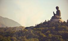
What are mountains? Mountains are heavily dissected parts of land, significantly, by 500 meters or more, elevated above the adjacent plains. The mountains are separated from the plains either directly by the foot of the slope or by foothills. Mountains can be linearly elongated or arcuate with a parallel, lattice, radial, feathery, echelon or branched dissection pattern. Distinguish between high, medium and low mountains.
Shape of mountains Mountains form in tectonically active areas; By origin, mountains are divided into: tectonic, erosional, volcanic. Depending on the nature of the deformations of the earth's crust, tectonic mountains are divided into folded, blocky and folded-blocky.
Place of mountains on planet earth. Mountain systems occupy 64% of the surface of Asia, 36% - North America, 25% - Europe, 22% - South America, 17% - Australia and 3% - Africa. Overall 24% earth's surface belongs to the mountains. 10% of all people live in the mountains. Most of the world's rivers originate in mountains.
Forms mountainous terrain Depending on the area occupied by the mountains, their structure and age, they distinguish: isolated uplifts of small extent, the so-called island mountains (for example, the Khibiny); mountain groups; mountain ranges- large linearly elongated elevations of the relief, isolated or constituent elements of mountainous countries (systems); the intersection or junction of two or more mountain ranges are called mountain nodes; a mountain junction may also represent the center of several radially divergent ranges; mountain ranges - sections of mountainous countries located more or less isolated and having approximately the same length in length and width (for example, Mont Blanc in the Alps); differ in relatively weak dismemberment, from neighboring ridges mountain country separated by wide and deep valleys; mountain systems - mountains united territorially, having a common cause of origin and possessing morphological unity;
mountain belts of the earth mountain belts - the largest unit in the classification of mountainous relief, represents several mountain systems, elongated into a single (solid or intermittent) strip; this includes, for example, the Alpine-Himalayan mountain belt (stretches from Western Europe to the southeastern tip of Asia) and the Andes mountain belt - the Cordillera, stretched along the western outskirts of North and South America.
On the topic: methodological developments, presentations and notes
KTD "Burn, burn, fire of the Olympics"
Goals: - updating information about the XXII Olympic Winter Games; - the formation of stable knowledge and understanding of the values of the Olympic Movement by schoolchildren; - fostering a sense of collectivism, friendship and mutual...
Technological map of the lesson on the subject "Music" in the 2nd grade. Section "Burn, burn brightly so that it does not go out." Theme "Folklore - folk wisdom".
This publication is a technological map of an open lesson, which sequentially sets out the sections of the lesson and the corresponding UUD. The lesson introduces students to folk art, on ...

What are mountains?
- Mountains- a positive landform, raised above the plains. Mountains represent dissected areas of the earth's surface with significant elevation differences(from several tens of meters to several kilometers).
Insert a map of your country.

Mountains of different continents
Mountains of Africa
Mountains of Eurasia
Mountains of North America
Mountains of South America
Insert a picture of one of the geographic features of your country.
Mountains of Australia
Mountains of Antarctica
end the show

kilimanjaro
- kilimanjaro- a mountain range in the northeast of Tanzania, the highest point in Africa above sea level - 5895m. Kilimanjaro rises above the Masai plateau, which is located at an altitude of 900 meters above sea level.
In 2003, scientists concluded that molten lava is only 400 meters below the crater main summit Kibo. Although no other activity is predicted other than the current gas emissions, there are fears that the volcano could collapse, leading to a major eruption.
Insert a picture illustrating a season in your country.


Chomolungma
- Chomolungma - highest peak the globe height according to various sources from 8844 to 8852 m. It is located in the Himalayas. Located on the border of Nepal and China, the peak itself lies on the territory of China. Has the shape of a pyramid. The southern slope is steeper. Glaciers flow from the massif in all directions, ending at an altitude of about 5 thousand meters. On the southern slope and ribs of the pyramid, snow and firn are not retained, as a result of which they are exposed.
Insert a picture of an animal and or plant found in your country.


McKinley
- McKinley- double-headed mountain in Alaska, highest mountain North America. Located in the center national park Denali. During the period of Russian colonization, Alaska was simply called Big Mountain.
Relative height - 6138 m.
Insert a picture illustrating a custom or tradition here.


aconcagua
- Aconcagua- the highest extinct volcano in the world. Height 6962 m. highest point American continent, South America, western and southern hemispheres.

Insert a picture of the head leader of your country.

Kosciuszko
- Kosciuszko- the highest peak of the Australian continent. Altitude 2228 m. Located in the Australian Alps. The first person to climb its peak was Pole Edmund Strzelecki, who gave the mountain its name in honor of the Polish-American military figure Tadeusz Kosciuszko. .


Caucasian mountains.
CaucasusHighest point: Mt. Elbrus (5642 m)
Area: 440 thousand km
Main ridge: Main Caucasian ridge (1200 km) Period of creation: Alpine folding
The territory on the border of Europe and Asia, between the Black. Caspian and Seas of Azov. It consists of the Caucasus Mountains (mainly the Greater Caucasus) and the adjacent regions of the North and South Caucasus. The North Caucasus, which lies to the north, includes flat (Kuban) and foothill (Civcaucasia) lands and is entirely part of Russia.
To the south lies the South Caucasus. divided between the partially recognized South Ossetia and Abkhazia as well as Georgia, Azerbaijan and Armenia. Altitude 5642 m (Mount Elbrus). There are rich oil deposits.
Borders
The indisputable borders in the west and east are the Black, Azov and Caspian Sea. In the north the physical and geographical boundary is usually considered the Kuma-Manych depression, the modern administrative - northern borders Krasnodar and Stavropol Territories and Dagestan.


Borders.
Sometimes Kalmykia is conditionally referred to the Caucasus. Although historically and ethnographically most North Caucasus much closer to the southern Russian steppes and the Lower Volga region, and then the border of the Caucasus can be drawn along the rivers Kuban, the upper reaches of the Kuma, Malka and Terek. This territory includes the south Krasnodar Territory, Adygea, Karachay-Cherkessia, Kabardino-Balkaria, North Ossetia, Ingushetia. Chechnya and most of Dagestan.
It is even more difficult with southern border of the Caucasus (and Transcaucasia). Politically, it is now being carried out along the borders of Turkey and Iran, on the one hand, and Georgia, Armenia, and Azerbaijan, on the other.
As such, this border
finally formed only in 1921 (after the transfer of Artvin, Kars
And Ardahan), but began to take shape a century before with the gradual accession of the Transcaucasian khanates and kingdoms to Russia in 1805-29. It is much more difficult to draw the historical, ethnographic and linguistic border of the Caucasus: the historical lands of the Armenians stretch far to the west and south, and the Azerbaijanis still inhabit most of northwestern Iran. The most justified is the inclusion in the Caucasus of the north-eastern regions of Turkey, which were once part of Georgia and Armenia - Artvin silts. Ardahan and Kare, where the Kartvel-speaking Laz and Georgians are still preserved
And Armenian-speaking Hemshils.

Countries and regions of the Caucasus
1.Armenia
2. Abkhazia
3.Adygea
4. Azerbaijan
5.Armenia
6.Georgia
7. Dagestan
8. Ingushetia
9.Kabardino-Balkaria
10. Karachay-Cherkessia
11. Krasnodar Territory
12. Nagorno-Karabakh
13.Nakhichevan
14. Rostov region
15. Stavropol Territory
16. North Ossetia
17. Chechnya
18. South Ossetia.

Territory of the Caucasus.
The Caucasus occupies an area of about 440 thousand km2 and consists of five main landscape areas- Ciscaucasia, the Greater Caucasus, the Transcaucasian lowlands (Kolkhis and Kura-Araks), the Lesser Caucasus and the Javakhetian-Armenian Highlands (the northeastern part of the Armenian Highlands.
In addition, at the extreme in the southeast, the Talysh mountains, which are part of the Iranian
highlands, and the Lankaran lowland separating them from the Caspian Sea.

The structure of the Caucasus.
The Caucasus is located within Alpine-Himalayan mobile belt with active latest tectonic movements and is characterized by a variety of mountainous terrain. In the center of Ciscaucasia is the Stavropol Upland ( highest point- Mount Strizhament, 831 m), separating the Kuban-Azov and Terek-Kuma lowlands. In the south of the Ciscaucasia, in the interfluve of the Terek and Sunzha, there are two low-mountain ranges - Tersky and Sunzhensky, separated by the Alkhanchurt valley.
The mountain system of the Greater Caucasus is divided by length into Western, gradually rising from the Taman Peninsula to Elbrus (the highest point of the Caucasus, 5642 m), high-mountainous Central (between Elbrus and Kazbek) and Eastern, decreasing from Kazbek to Apsheron